

More wet weather for Saturday and the end of next week
Thursday, June 4, 2015
The current warm and dry weather will end by tomorrow as a storm along the West Coast draws moisture from once-hurricane Andres over our area. Clouds will thicken during the day and showers will occur tomorrow afternoon and through the evening. There will be a small break early Saturday before a lobe of energy is ejected over our area ahead of the eastward progressing West Coast storm, bringing another round of moderate to heavy rain for Saturday afternoon.
There will be another break Sunday before the storm to our west lifts toward the northeast and travels across the Great Basin. Though the storm weakens considerably, there is still enough moisture and upward motion to to produce showers by Sunday afternoon.
We will still be under the influence of the weakened storm on Monday, leading to more showers, especially in the afternoon. Tuesday and Wednesday look to be the nicest days of next week, though there will still be the threat of the typical afternoon thunderstorm.
There is a wildcard for the forecast next week in the form of hurricane Blanca, which is forecast to move up the Baja coast early next week. Earlier model runs had the moisture moving over our area, but current runs keep most of the moisture to our south. However, models also forecast a complicated interaction between the former hurricane, another storm entering the West Coast around midweek, and a surge of cool air from the Canadian plains. These three entities may conspire to increase the threat of heavy rain by Thursday afternoon and lasting through Friday. That forecast will likely evolve as we get closer to the event.
After that, some models predict a far-western Caribbean storm that may help draw moisture northward and lead to a monsoonal-like surge of moisture over our area for late next weekend or early the following workweek.
Summer weather begins Saturday
Thursday, May 28, 2015
Our long-delayed summer weather begins on Saturday, but not before the wave currently affecting our area leaves more rain today and Friday. Rainfall should end by early Saturday as the wave moves east of our area.
Saturday should start out cool, but temperatures will begin to warm during the day. The cool airmass left behind will likely support storms of minimal strength and it’s possible we may even have a rain-free day for the first time in about 3 weeks, though that hope may be threatened by a very weak wave passing north of our area by late in the day and overnight.
The upper-elevation snowpack will see its first above-freezing low temperatures in three weeks Saturday night, signaling the beginning of its melting and contributing to increasing river flows, especially early next week as it may take a day for that water to make it to the Yampa river.
The warming temperatures will certainly make the weather feel summer-like, and yield typical summer afternoon thunderstorms Sunday through Tuesday.
A wave traveling across the northern third of the US will clip our area and knock temperatures back on Wednesday, as well as the strength of the afternoon storms. There is a possibility, however, that rain will be more persistent late in the day and overnight.
A much stronger storm crashes into the California coast around Thursday, though there is a significant amount of dry air ahead of the storm that will be brought over our area through the end of the workweek as the flow backs to the southwest. The evolution of this wave is complicated as it is not clear how much splitting will occur and how much of the cold air still in the Canadian plains will be drawn into the system, but this may threaten next weekend’s weather.
Generally, for the longer term, there is additional Pacific energy forecast to enter the West Coast as well as a westward expansion of the cool airmass over the Canadian plains. The combination of these is forecast to inhibit the West Coast ridge from building, keeping our weather on the seasonably wet side through at least mid-June.
Rinse and repeat
Thursday, May 21, 2015
The forecast is sounding like a broken record (remember those?!), but the rain looks to continue as four more waves move over our area through mid-next week. For water managers out there that believe the snowpack does not accumulate moisture after May 1, 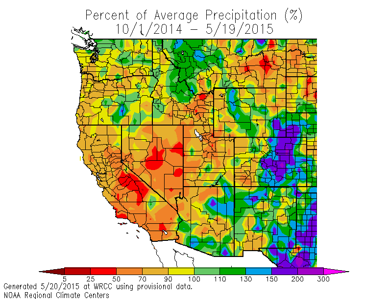 note that the Snotel remote measuring site near the top of Buffalo Pass called Tower registered a local low in snow depth on May 8 of 69” with about 28” of liquid water. In twelve days, the snowpack increased about 8”, but remarkably the liquid water content increased by 3.5”! The end result is that the below average water year for Routt county that began on October 1 is now above average over most of the county. The southern part of the county is between 10 and 30% above average, while a small area in the extreme northeast is still lagging at between 10 and 30% below average, with the rest of the county as much as 10% over average!
In the short term, rain starts up again early this afternoon as the morning heating interacts with substantial low-level moisture and produces another round of scattered rain showers. However, unlike the previous 2 nights, rain should increase tonight and become moderate to heavy as the first wave from the southwest ejects over our area this evening.
There is a small amount of drying advertised by some models early in the day tomorrow, but again any heating will act on a very moist airmass to produce another round of afternoon rainstorms.
Some more drying is forecast early Saturday as a strong storm that ejected the Thursday night wave approaches the area, but again we will be susceptible to scattered afternoon rainstorms. As the storm moves over the area early Sunday, some cool air from the Canadian plains related to a wave to our north and east will be mixed into the storm, lowering snow levels to around 9000′ and again leading to a wet day.
Skies will briefly clear by Monday morning before the fourth wave, forecast to be located over the Four Corners region by Monday afternoon, again increases rainfall later in the day and overnight.
The parade of relatively organized storms will be briefly interrupted midweek, but clear mornings should give way to the typical afternoon thunderstorms as the strong May sun interacts with a very moist atmosphere.
Additional Pacific energy enters the West Coast later in the week, though forecasts are uncertain as to the amount of mixing between the southern stream over central California and the northern stream over the Pacific Northwest. Nonetheless, it looks likely the unsettled weather will continue into next weekend, with the pattern likely continuing into at least the first week of June as additional Pacific energy is forecast to crash into the West Coast.
Wet and cool weather to continue
Thursday, May 14, 2015
The wet and cool long-range forecast I’ve been talking about since mid April looks to continue through at least the end of the month as Pacific energy continues to enter the West Coast and tap, to varying degrees. the cold air over the central Canadian plains.
In the short-term, and similar to last weekend, a large and complex storm currently along the West Coast will keep the current unsettled weather going through the weekend. Showers will begin around mid-afternoon today and intensify for a period this evening before briefly ending around midnight.
However, continued pieces of energy ejecting from this storm as it moves eastward will reinvigorate the showers by Friday morning, and keep them going through the day and into the overnight hours. Additionally, temperatures will be cool as the storm approaches the area.
Some energy entering the West Coast around southern California on Friday will lead to a partially split system that first decreases or even ends the rain over our area for Saturday morning. But showers will again increase later in the day as the southern part of the split storm moves first south and then east of our area by Saturday afternoon.
The northern portion of the split will pass mostly to our north, though a lobe of energy looks to pass over our area around Sunday morning, bringing significantly colder air to the region during the day. While the system is not as cold as last weekend, snow levels will eventually fall to around 8000′ with snowflakes again a possibility in the valley during the day Sunday and overnight.
The northern and southern portions of this split recombine to our northeast by later in the day Sunday, dragging the coldest air of this storm over our area by Monday morning and leading to the lowest snow levels of the event overnight Sunday.
Precipitation will only briefly end as another Pacific storm crosses the West Coast on Monday and increases showers again by Monday afternoon. These showers will only intensify as energy is ejected from this new storm, and will turn into more persistent rain later Tuesday as the storm crosses over the area.
Conditions will finally moderate for a short time midweek, though afternoon storms are likely with lots of moisture hanging around after the two storms.
Yet another storm will threaten Memorial Day weekend, though the forecast for then is uncertain as the American GFS takes a lead shortwave across the area near the end of the workweek before bringing a much stronger storm across the West Coast by late in the weekend, with relatively drier weather in between. The European ECMWF has these two waves moving across more coherently earlier in the weekend leading to a wetter forecast.
Wet and cold weekend followed by improving conditions next week
Friday, May 8, 2015
A large and impressively cold storm currently located near Las Vegas will first move eastward across the southern Great Basin and then northeastward over Colorado through the weekend, continuing the current streak of wet weather. Furthermore, this very cold storm will likely bring snowflakes to the valley floor as early as Saturday night and accumulating snows down to 8000 feet or so, though most of the precipitation will have ended by the time the coldest air arrives for the second half of the weekend.
Showers should decrease and possibly end later this afternoon as the current blob of energy ejected from the storm exits the area, but may pick up again this evening as pieces of energy are periodically ejected from the parent storm. By Saturday morning, the forecast position of the storm along the Colorado and New Mexico border may force a dry slot over our area during part of the day tomorrow, which, as the name implies, may bring precipitation-free and perhaps even sunny weather to our area for a time tomorrow.
Don’t be fooled by the break, though, as unseasonably cold air is is drawn southward over our area later in the day as the storm intensifies in eastern Colorado during Saturday afternoon. Moderate to sometime heavy precipitation will be noted around the frontal passage, with showers behind the front expected through the rest of the weekend and into Monday morning in the cold and unstable northwest flow behind the departing storm.
Temperatures will be slow to respond Monday, but by Tuesday we should be returning to more seasonable temperatures as another storm moving over the Baja peninsula approaches our area. Similar to the storm last Tuesday night, but considerably weaker, I expect rain showers to increase in much warmer air at all elevations by late in the day Tuesday and lasting through the day Wednesday.
We will have another break in steady precipitation on Thursday and Friday, though we may be susceptible to typical summer afternoon storms as very warm temperatures invade the area. There is considerable model uncertainty after this though, as the Amercian GFS keeps another major storm just west of our area through the weekend, while the European ECMWF, in the latest forecast from this afternoon, moves this storm over our area during the weekend.


