
Sunny skies return for the weekend
Thursday, September 30, 2021
Temperatures in the mid-fifties and partly sunny skies are over the Steamboat Springs area early this Thursday afternoon, with high temperatures today expected to be around sixty degrees. The temperatures will slowly warm through the weekend along with diminishing shower chances, with warm temperatures and sunny skies expected to start the new work week.
The storm that produced the eddy of low pressure currently over the Four Corners was responsible for moving out the previous eddy in the same area. This previous eddy produced good rainfall over the Yampa Valley as it moved near our area Tuesday night with around of inch of precipitation in town and an inch of snowfall at the top of Sunshine Peak by Wednesday morning, as noted by the recently recommissioned Steamboat Powdercam.
Unfortunately, the current eddy formed as a result of an incoming storm splitting more than I originally forecast in the last Sunday weather narrative, which meant the best cold air and storm energy missed our area. Temperatures will stay near the sixty degree mark today, which is five degrees below our average of 65 F, as an incoming Pacific storm makes landfall near Vancouver.
The Four Corners eddy moves very little until later Friday, but weakens, which means we’ll see more sun and some warming on Friday with high temperatures closer to average, with only a slight chance of some weak afternoon storms due to the remaining moisture.
While the bulk of the Vancouver storm is forecast to be in Montana early in the weekend, a small part shears to the southwest on Friday and ends up leaving an eddy off the West Coast that may be a player in our weather for the next work week. Coincidentally, the storm is forecast to kick the Four Corners eddy eastward across the Oklahoma Panhandle by Friday night, but the storm will too far south to affect our area.
Modest further warming is forecast for the weekend with lots of sun and hardly any shower chances, with high temperatures possibly breaching the seventy degree mark by Monday as a ridge of high pressure builds overhead.
Enjoy what is sure to be another very nice weekend, and be sure to check back Sunday afternoon for my next regularly scheduled weather narrative where I’ll have a better idea of whether that West Coat eddy affects our area around midweek.
Rain likely by midweek
Sunday, September 26, 2021
The Steamboat Springs area is enjoying another quintessential Colorado fall day with temperatures in the seventies and nary a cloud in sight this Sunday noon. The spectacular weather continues Monday before the weather becomes unsettled by later Tuesday and likely wet by Wednesday.
Two weather features will affect our weather by Tuesday afternoon; an eddy of low pressure currently in central Arizona and a strong storm currently in the Gulf of Alaska. But we’ll get another couple of gorgeous fall days today and Monday before the Gulf of Alaska storm is forecast to cross the Pacific Northwest coast Monday night.
The Arizona eddy will be forced to the northeast and toward our area on Tuesday as it is incorporated into the southwest flow ahead of the Pacific Northwest storm. There may be some clouds around on Monday at times in advance of the eddy, with cloudiness increasing on Tuesday ahead of increasing shower chances by Tuesday afternoon or evening.
Meanwhile, the Pacific Northwest storm is forecast to enter the Great Basin on Tuesday and send a cold front through our area on Wednesday. Between the subtropical moisture carried over our area by the eddy and the cold front with the approaching storm, expect high chances for widespread showers by Tuesday night, with lesser but still significant chances continuing through Wednesday.
While high temperatures today and tomorrow will be in the seventies, five to ten degrees above our average of 67 F, they will cool a bit Tuesday under the clouds, and drop to five to ten degrees below average on a showery Wednesday.
Snow levels behind the cold front should drop to between 9000′ and 10,000′, and though the coldest air comes late Wednesday after the best moisture has left the area, there should be up to an inch or two of snow on the upper third of Mt. Werner by Thursday morning.
The storm is expected to split over the Great Basin by late Wednesday, with a fair bit of uncertainty with respect to how much energy is partitioned between the eventual northern and southern parts of the storm, but right now another eddy that may eventually influence our weather is forecast to be left behind in the southern Great Basin or Desert Southwest. We may see some showers on Thursday afternoon that persist through the weekend, according the European ECMWF, or rapidly diminish, according to the American GFS, or some sort of compromise. Stay tuned to my next regularly scheduled weather narrative on Thursday afternoon where the weather for next weekend will be in better focus.
Pleasant weather continues through the weekend
Thursday, September 23, 2021
Temperatures are around seventy degrees with some increasing clouds early this Thursday afternoon in the Steamboat Springs area ahead of a grazing storm for Friday that will have little effect on our weather. Sunny skies with continued high temperatures in the seventies look to persist through the weekend and will make a perfect backdrop for viewing the changing fall colors.
A ridge of high pressure is currently over the Gulf of Alaska with a storm centered over Saskatchewan and another over the Great Lakes. The Saskatchewan storm has low pressure extending southwestward into the Great Basin, which is responsible for our cloudiness this afternoon. As the main part of the storm moves southeast into the upper Midwest through Friday, the southern part forms an eddy that moves southwest into the Desert Southwest and eventually southern California for the weekend. We will be grazed with a cool front from the northern portion of the storm tonight, with perhaps a few degrees of cooling but the return of sunny skies for Friday.
The ridge of high pressure is forecast to move overhead through the weekend and into next week, so the beautiful fall weather is expected to continue through then. Changes in the weather may be on our doorstep by around next Tuesday as a storm is forecast to develop in the Gulf of Alaska late in the weekend. We may or may not see effects from that Desert Southwest area of low pressure depending on its track as early as Tuesday, and will likely see effects from that Gulf of Alaska storm around midweek.
Enjoy the gorgeous weekend with warm sunny days and crisp nights and check back for my next regularly scheduled weather narrative on Sunday afternoon for details on the midweek change in the weather.
Cold front tonight might bring snowflakes to the Yampa Valley floor
Sunday, September 19, 2021
 After around a tenth of an inch of rainfall around the town of Steamboat Springs last night, temperatures are in the low sixties this Sunday noon with a mix of clouds and sun. A potent cold front this evening brings some snow to the higher elevations and perhaps even some snowflakes to the Yampa Valley floor by Monday morning. Much colder temperatures are expected to start the work week behind the front, with below freezing temperatures on Tuesday morning, before the sun returns and temperatures warm to around average by midweek.
An unseasonably cold storm currently moving through the Intermountain West has just brought some snow to the summit of Grand Targhee, with similar conditions expected for the Steamboat Ski Resort this evening. Ahead of the storm, temperatures should rise to around seventy degrees today, right at our average, with the possibility of a passing shower before the cold front arrives around mid-evening.
While moisture rapidly increases with the windy cold front, it also rapidly decreases behind it, so expect some good rain showers at the lower elevations and snow showers at the higher elevations, with the stronger showers perhaps briefly allowing snowflakes to reach the valley floor. Another push of cold air is forecast after midnight and before sunrise, accompanied by some showers which may again bring some snowflakes to town. All told, we may see around a quarter or third of an inch of precipitation by Monday morning.
Temperatures should be around freezing Monday morning, with likely clouds tempering the low temperatures, before the skies clear and a mix of sun and clouds return, though high temperatures will be mired in the fifties. A reinforcing surge of dry cold air arrives Monday night, and with the forecast clear skies, low temperatures will plummet to ten to fifteen degrees below our average of 34 F. Simply covering plants may not be enough to stave off the hard freeze, so consider harvesting whatever fruits and vegetables that are still growing.
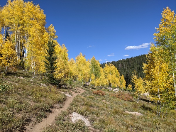
A ridge of high pressure begins to move over the Rockies on Tuesday, so despite the cold start to the day, temperatures are expected to rise into the sixties with plenty of sun. This should begin an extended period of prime leaf-peeping as the low elevation underbrush and higher elevation aspen, shown in the included picture taken Friday on the Flash of Gold trail, are now turning. Even more warming is advertised for Wednesday as temperatures recover to around average.
Another incoming storm forecast to move through the Gulf of Alaska on Tuesday is forecast to move that ridge of high pressure to our east, though there is weather forecast model uncertainty as to how much of the storm forms an eddy in the vicinity of the Great Basin or further southwest and how much continues east. We may see a drop in temperatures by a few degrees on Thursday according the the American GFS, but along with plenty of sun as the grazing cool front will be dry.
Weather forecast models should have a much better handle on how much of the storm lingers over or southwest of the Great Basin for the weekend, and I’ll have details on whether that might affect our weekend weather in my next regularly scheduled weather narrative on Thursday afternoon.
Chance for showers returns mid-weekend
Thursday, September 16, 2021
Temperatures in the upper seventies along with mostly sunny skies and breezy winds are over the Steamboat Springs area this Thursday mid-afternoon. Similar weather is forecast for Friday and most of Saturday, with sunnier skies, before some moisture is forecast to move overhead on Saturday night and Sunday and increase the chance for showers, followed by a dramatic cool-down on Monday.
A mostly dry storm currently moving across the northern Rockies is responsible for our increased winds and patchy clouds this afternoon. A cool front will graze Colorado tonight with most of the cold air confined to the Front Range, so expect a bit less wind on Friday along with more sun and similar temperatures in the mid to upper seventies, which is above our average high temperature of 71 F.
Saturday starts in a similar fashion, but an area of low pressure currently off the coast of southern California will be forced eastward ahead of a potent storm forecast to develop in the Gulf of Alaska through the weekend. Southerly flow ahead of that northeastward-moving area of low pressure will bring moisture from the south over our area starting later Saturday, so look for an increase in clouds with the chance of light showers developing. These chances should continue overnight and into Sunday morning when the area of low pressure is forecast to pass overhead.
Coincidentally, the unseasonably cold Gulf of Alaska storm is forecast to cross the Pacific Northwest coast Sunday morning and move through the Great Basin overnight. There may enough moisture left behind the departing low pressure disturbance and ahead of the incoming storm for some clouds, slightly cooler temperatures and a small chance of afternoon showers for the rest of Sunday.
Weather forecast models have struggled with the intensity, speed and moisture content of the incoming storm, with even snowflakes earlier forecast down to the Yampa Valley floor, but models have backed off that solution and right now several mostly dry surges of cold air look to pass through our area between Sunday and Monday nights.
Be sure to check back for my next regularly scheduled weather narrative on Sunday afternoon where I’ll be discussing the incoming storm and how cold the beginning of the work week may be.


