
Weak and warm storms for Sunday, midweek and next weekend
Saturday, November 29, 2014
After some partly sunny days, moisture should increase later tonight and tomorrow ahead of a weak storm that will peak Sunday night or early Monday morning. Areas north of Steamboat will be favored, but only an inch or two is expected to be reported on the hill by Monday morning.
Light snows will end by noon Monday and clouds will decrease through the afternoon, leaving partly cloudy skies for the rest of the day and Tuesday.
A storm currently off the coast of California will move inland and affect our weather for Wednesday and Thursday. Models have trended weaker and warmer with this storm, but it still looks like we will receive not insignificant amounts of snow starting Wednesday afternoon and extending into Thursday. The most favorable time for snow will occur Wednesday night and Thursday morning as there is a subtle wind shift to northwest flow around then, but amounts will be limited by warm temperatures and light wind speeds. Based on the latest model runs, we may see 3-6” between noon Wednesday and noon Thursday.
Several weak and continued warm waves are forecast to follow this storm and pass over the area from Friday through the weekend, keeping the threat of light precipitation present.
Opening day conditions were …interesting
Wednesday, November 26, 2014
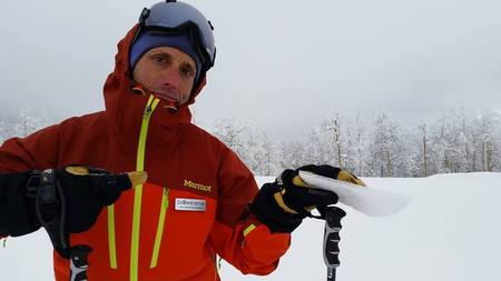 The freezing rain event that started the afternoon before the Steamboat Ski area opened for the 2014-2015 ski season ruined about 30” of powder that had fallen in the previous 3 days.
 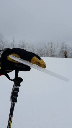 But plans were made, and our group dutifully showed up at the gondola line at 7:30am, hoping for anything better than the ice-crust left in the valley snowpack.
We headed to White Out, but probed the snow prior to committing, and found an even thicker layer of ice at the top of Norther. Skiers behind us noisily and spectacularly proved that off-piste was unskiable, and we took the cat track around to Rudi’s Run, which was nice for early season conditions, but disappointing for those with powder expectations.
Shown on the left is a closeup of a nice slab of crust excavated from the top of Hurricane. After obtaining photographic documentation, we found Heavenly Daze and especially Vogue as having the softest snow on the hill.
Sun should return tomorrow, and we’ll see what the grooming crews can do to mitigate the damaged snowpack.
Powder day potential ends with the crackle of ice
Boy, forecasting is hard. And humbling. And what did I say about changing a forecast in the last post!?
Originally, I had thought the final wave in the storm cycle timed for Tuesday would struggle to produce snow in the warming atmosphere forecasted by the models. In fact, the temperature up top rose from about 3F first thing Tuesday morning to about 19F by the early evening. However, during the morning hours and until the early afternoon, snow was falling both up top and here in the valley at about 0.5”/hr as temperatures warmed, and that prompted me to revise my guarded forecast to be more optimistic.
I even joked how I don’t like to revise forecasts for the very reason that it tends to break BOTH the original forecast and the revision!
I heard reports from the hill today that by about 2pm or so yesterday, freezing rain had started on the upper mountain and quickly crusted over the high quality powder. The valley saw freezing rain by around 4:30pm, and then periods of mixed precipitation and freezing rain through the evening hours. Furthermore, the Tower SNOTEL site indicated about an inch of precipitation fell from late afternoon yesterday through early this morning without any increase in the snowpack depth, indicating rain or freezing rain was impacting the measurement there as well.
Freezing rain occurs when an elevated warm and moist layer above freezing sits above a cool layer of air below freezing. So, there must have been this layer somewhere above 10,000′, though I can’t find it in any of the upstream observations. Animations of satellite pictures do show the north-northwest to south-southeast jet stream moving eastward and allowing warmer air to enter the area as forecast, but I did not expect it to be above freezing above 10,000′. Furthermore, the average temperature profile of the atmosphere over our area was cold enough for snow, but in hindsight a thin warm layer would not significantly change the average temperature over a much deeper layer.
The end result was I missed forecasting freezing rain on the hill because of this thin warm layer, which meant the inch of liquid that should have produced a foot of snow stayed as rain. And produced a layer of ice 1/4” thick up top. In fact, the ice crust grew thicker with elevation as there was not enough time for any of the rain to turn to sleet before freezing on the snow surface near the top. At this point, I’m finding it hard to find the evidence I missed that would have created a better forecast.
While rain on the upper hill is not likely in the winter here, it does happen, albeit very infrequently. Freezing rain, on the other hand, is a much rarer occurrence.
Scholarship Day forecast update
Tuesday, November 25, 2014
Snow has started earlier than I anticipated, with a couple of inches of snow already accumulated on my deck. There was some slight warming aloft that I though would inhibit snowfall this morning, but this warmer layer ended up being above mountain top and thus has not adversely affected snowfall production.
So, not only will we have more snow than the 5-10” I forecast yesterday because it started earlier, but it is likely to be more productive than I originally thought. I usually don’t change a forecast this close to an event (since that has a habit of breaking BOTH the original forecast and the updated forecast), but it seems likely we will see 8-16” on the hill by tomorrow morning.
More snow for Wednesday’s Scholarship Day
Monday, November 24, 2014
The forecast from last Tuesday was so good I did not need to update it! It appears that the Steamboat Ski Area started posting mid-mountain 24 hour snow totals on their website, though I am assuming (because Steamboat STILL insists on NOT including a datestamp on their observations - feel free to email them and let them know their numbers are near useless if we don’t know the time period they represent!) 8” was reported yesterday morning and 9” was reported this morning.
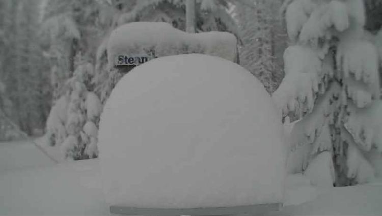 As you can tell from the Powdercam picture taken around 9 am this morning, there is over 2 feet of settled storm snow up top from Saturday afternoon when the current storm cycle started.
More snow will accumulate through the daylight hours today, with an enhancement increasing snowfall rates early this afternoon. Probably 5-10” of snow will be reported by tomorrow morning, though most of that has already fallen.
Snow will taper off after sunset tonight, though it may not completely stop. The last wave in this storm cycle will bring some slight warming and windy conditions starting tomorrow afternoon and lasting through midday Wednesday. Snow will increase during the day tomorrow and become moderate to heavy overnight before tapering off by Wednesday around noon, but I would expect another 5-10” for the Wednesday morning report, with another 1-4” of new snow falling by noon.
Conditions will rapidly improve later Wednesday with significant warming by Thanksgiving Day, as the forecast made by the American GFS last week verifies over the European ECMWF forecast from then. Beautiful and mostly sunny weather should persist into the weekend before a weak wave in northwest flow grazes our area on Saturday. At this point, some cooler air and clouds look to be the only impact.
Temperatures warm again heading into early next week before another strong storm is forecast to affect our area sometime around Tuesday.


