
Strong wintry storm to start Monday night
Sunday, March 30, 2025
Temperatures are around forty degrees under cloudy skies this Sunday mid-afternoon in Steamboat Springs and twenty-five degrees at the top of the Steamboat Ski Resort. A final wave in this series that started Friday night will pass overhead tonight before a break on Monday. A much colder winter-like storm crossing the West Coast will bring a strong cold front through our area Monday night, accompanied by moderate to heavy snow showers expected to last through Tuesday. Lighter snow showers and cold temperatures look to stick around into next weekend.
The two waves on Friday and Saturday nights left six inches of snow at mid-mountain and ten inches up top by the Sunday morning report, with another inch at mid-mountain and two inches falling up top this morning.
A final wave in this series will pass through Colorado tonight, possibly leaving as much as an inch or two at mid-mountain, before a break on Monday. But as discussed in last Thursday’s weather narrative, a replacement storm is now affecting the West Coast, and after ingesting some cold western Canadian air, will intensify as it moves through the Great Basin starting Monday night. While the storm will split by Tuesday, with the eastern part traveling over Colorado and the western part diving south toward Baja, there is enough cold air and forcing to bring significant wintry weather to the West.
Our area can expect a strong cold front Monday night, with moderate to heavy snow showers along and behind the front continuing through Tuesday, accompanied by gusty westerly winds as high as 50 mph at pass level , making travel difficult. We could see 4-8” by the Tuesday morning mid-mountain report, with that again during the day, along with much colder temperatures. While mountain-top temperatures will start the day in the low-teens, high temperatures in town will be mired in the thirties, over fifteen degrees below our average of fifty, which will be a shock after the recent warm spring weather, especially since it will be accompanied by several inches of snow.
While the leading storm will be east of our area by Wednesday, the storm moving toward Baja will be reinforced by more western Canadian cold air so that the entire West remains in a cold and unsettled weather pattern. Intermittent snow showers will continue Tuesday night into Wednesday morning at all elevations, with temperatures similar to Tuesday. While the bulk of the snowfall will be over by Tuesday afternoon, some continued accumulations in town and 1-4” on the hill are possible for the Wednesday morning report.
More energy dropping into the backside of the Baja storm keeps unsettled but slightly warmer weather around on Thursday before the storm eventually forms an eddy on Friday, which may or may not affect our area heading into next weekend. So enjoy another blast of wintry weather, and check back for details on next weekend’s weather in my next regularly scheduled weather narrative on Thursday afternoon.
Cool front tonight followed by continued hot and dry weather
Thursday, June 10, 2021
Temperatures in the low to mid-eighties and gusty winds from the south and southwest are over the Steamboat Springs area this Thursday afternoon. We’ll see some relief from the heat as a cool front moves through tonight along with a chilly start to Friday morning, but the hot and dry weather returns for the following week.
As an administrative note, I have turned back on the NOAA Smoke Plume forecasts for those interested in following where smoke that may be over our area is coming from and how thick it may be, and the first blog post where I discussed this model is here.
A compact and powerful storm for the season that brought some accumulating snow to the northern California mountains last night is currently rotating through the northern Great Basin. We will see continued hot and windy weather ahead of the storm today before the grazing storm brings a cool front through our area tonight. So expect a cool Friday morning with temperatures in the thirties which may require any outdoor plants to be covered, with temperatures quickly warming to five to ten degrees or so above our average high temperature of 72 F.
A ridge of high pressure rebuilds over the Rocky Mountains ahead of another powerful storm that is forecast to spin in the Gulf of Alaska through the early part of next week. So expect more summery days filled with sunshine and hot temperatures with relatively quiet winds.
Some of the storm in the Gulf of Alaska is forecast to eject inland by incoming energy traveling through the northern Pacific, but the massive ridge of high pressure over the Rocky Mountains will resist. The battle between the air masses will result in the storm being shunted to our northwest and into the central Canadian Plains through midweek, with no changes to our weather expected till perhaps near the end of the work week.
Interestingly, the battle will deform the ridge of high pressure for a time before it is forecast to rebuild further west. If this happens as currently forecast, we may see some relatively cooler temperatures for the end of the work week and next weekend along with some very modest shower chances as the upper level flow turns to be from our favorable northwest direction.
Enjoy the quintessential Colorado summery weather this upcoming week, and I’ll have more details on the possible shower chances to end the work week in my next regularly scheduled weather narrative on Sunday afternoon.
Change to the Morning Ski Report
Friday, February 14, 2020
I’ve changed the methodology used to produce the morning ski reports as of yesterday, 13 Feb 2020. As you may or may not know, SnowAlarm collates ski reports from around the continent from various sources, including the ski areas themselves, and you can sign up for free to have these emailed or texted to you.
Some of these sources allow the ski areas to report through the day, so my previous methodology of choosing the first available morning report could produce incomplete data depending upon the source. This made it difficult to tally the 24 hour snowfall totals over multi-day storms.
The morning report is now based upon the latest available ski report before 10 am local time. This now allows for the easy retrieval of 24 hour snowfall totals from previous days.
Three day time series of SNOTEL temperatures at Buffalo Pass and Rabbit Ears Pass added!
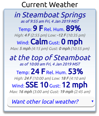
Friday, January 4, 2019
I am now decoding the SNOTEL (snow telemetry) sites for Buffalo Pass (elevation 10.500′) and Rabbit Ears Pass (elevation 9,400′) and presenting them as a three day timerseries. This provides another source of temperature data at elevations similar to the top of Mt. Werner and mid-mountain, respectively.
 They are available on the home page, with more details about three day timeseries here.
Also note that I am now displaying the current summit temperatures and winds for the Steamboat Ski Area and the town of Steamboat Springs (from the Bob Adams airport) at the top of the home page (along with a daily summary of the high and low temperatures and maximum wind speed and gust and time of occurrence) for quick reference. I always check these data before heading out on the hill.
I am considering the addition of other locations; please email me your favorite locations and I’ll try and find a station nearby.
Finally, note that you can access all timeseries from the Want other local weather? pulldown, which is also located under the Local Temperatures, Winds & Precipitation heading
Three day time series of Steamboat Springs temperature and wind added!
Friday, July 6, 2018

I’ve added some new functionality to the home page that displays a time series of the Steamboat Springs temperature, relative humidity, wind, wind gust and wind direction over the last three days from the local Bob Adams airport.
I also show a weather summary of the maximum and minimum temperatures below the temperature chart and the maximum wind and wind gust below the wind chart.
Click on the heading ‘Local Temperatures, Winds & Precipitation‘ on the home page to access it.
Note that clicking on the image will open a new window with a larger and more detailed view.
I’ve also added the ability to view a three day time series for Hayden and Denver. I am considering the addition of other locations; please email me your favorite locations and I’ll try and find a station nearby that reports to the National Weather Service, and I’ll see what I can do.


