
Steamboat ski area receives first snow
Tuesday, September 30, 2014
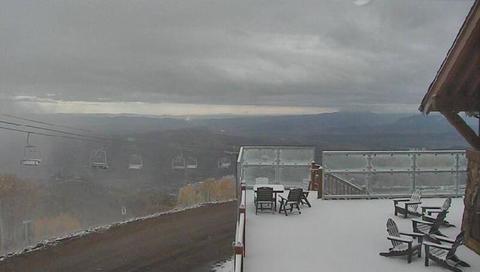 First snowfall for the Steamboat ski area arrived yesterday afternoon as the upper low advertised in last Thursdays forecast moved over our area about 12 hours slower than I thought. This picture was taken around 8:15 am Tuesday morning 30 September 2014 and is from the Four Points Lodge Mountain Cam. Unsettled weather will continue today and tomorrow with the last and coldest part of the storm pushing through tomorrow afternoon, bringing accumulating snow to the mountain tomorrow afternoon and likely snowflakes to the valley floor by Wednesday night.
Big storm ends weekend and lasts through most of the workweek
Thursday, September 25, 2014
The storm advertised last week will begin affecting our weather by Saturday afternoon as it moves from its current location in the Gulf of Alaska southeastward towards the Great Basin over the weekend. Moisture drawn from the southwest ahead of the storm will move over our area during the day Saturday and will create the threat of some wetting rains, especially in the afternoon and evening.
The low is forecast to become cutoff from the main westerlies by mid-weekend, and waves rotating around this cutoff will eventually bring moderate to heavy rain to our area during the day Sunday. There may be breaks in the precipitation, but rain will continue for most of Monday as the upper cutoff low approaches and eventually moves over us by Monday night. As that happens, the cool flow will turn to the Steamboat’s favored northwest location and keep the chance of rain showers for the valleys and possible snow showers for the higher elevations going through Tuesday until early Wednesday morning.
There is considerable inter-model and intra-model uncertainty with the eastward speed of the cutoff low that may slow its eastward progression by a half day or so. Additionally, there are another two waves upstream, with the first bringing a reinforcing surge of cool air by Wednesday.
The second storm looks to be quite strong as it travels southeastward from the Pacific northwest by Friday. The southwest flow ahead of that storm looks to bring some brief warming and drying ahead of the storm by late in the workweek, but some models have it finally moving over our area sometime next weekend. This storm is currently advertised to bring a stronger push of cold air over our region and may threaten snow near the valley bottom.
Spectacular sunset instead of rain
Saturday, September 20, 2014

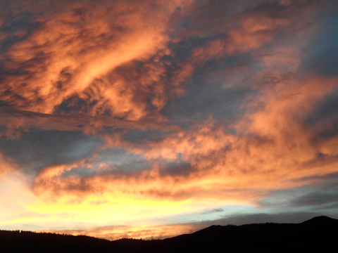 The first part of the storm forecast for this weekend was weaker and drier than expected, bringing some scattered clouds into our area late in the afternon. Rather than rain, a spectacular sunset graced Steamboat Springs last night.
Both of these were taken looking west towards Emerald Mountain from my deck Friday evening.
I still expect the second part of the storm, which is currently a cutoff low just off the coast of south-central California, to move westward during the day tomorrow, bringing first showers earlier in the day and then moderate to heavy rains by the late afternoon or early evening. Rain and rain showers will continue during the day Monday, until the upper low moves east of our area by early Tuesday, bringing warming and drying to the area.
From Green to Gold in 2 days at the Steamboat Ski Area
Friday, September 19, 2014
After a late start, the fall color show has seemingly appeared overnight! Well, not quite overnight, but literally in several days. Monday afternoon, the Twilight trees in the Priest Creek Area were tinged with light green, by Tuesday they were light yellowish and by Wednesday they were full yellow.
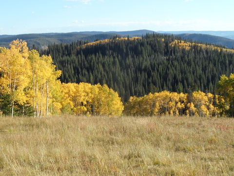
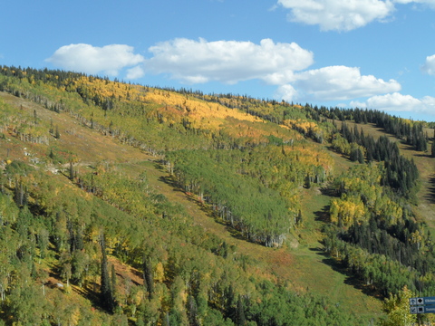 I escaped for a mid-afternon ride Thursday afternoon as temperatures touched 80F in the Yampa Valley. I took the this picture looking over Priest Creek from the Elkhead loop, and you can see the Duster road cutting horizontally across the middle of the picture.
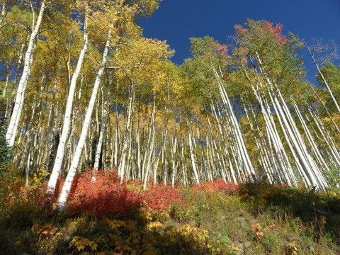 I like riding the Sunshine loop in a counter-clockwise direction, so the next picture is taken from the Duster road looking up at the Twilight trees. The underbrush has turned a beautiful red color which contrasts nicely with the aspen.
 This picture was taken looking down what I believe is Flintlock about a third of the way up the new reroute of the Sunshine Trail
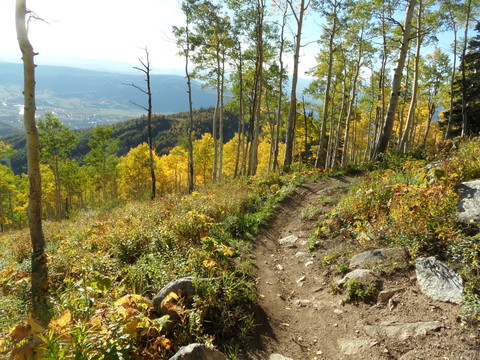 Finally, I took this picture cruising down the long traverse on Sunshine Trail somewhere in the Shadows area. You can see the town of Steamboat Springs over the ridge in the left hand side of the picture down in the valley floor.
Showers bookend a nice fall weekend
Thursday, September 18, 2014
Currently, a beautiful and warm fall day is gracing our area with the remnants of former hurricane Odile staying to our south and a Pacific storm approaching the west coast. This storm will split, with the progressive northern branch bringing showers and some cooling to our area by tomorrow afternoon and lasting for some of the evening.
Saturday and some of Sunday will be precipitation-free before the cutoff part of the Friday storm left behind in central California moves westward. Interestingly, some of Odile’s moisture will be drawn into the system even though the former hurricane will be east of our area, leading to the possibility of moderate to heavy rains by later in the day Sunday and Sunday night. The start of precipitation is uncertain at this time as models disagree on how quickly the difficult-to-forecast cutoff low moves west, but it should be raining by sometime in the afternoon and the rains will continue through midnight.
Rain will turn to showers on Monday and will continue through the day as that cutoff low moves over our area. Some showers may be moderate to heavy later in the day as moist and cool northwest flow is predicted behind the storm. Models disagree on whether the storm lingers for Tuesday, but conditions should rapidly improve and skies clear as a strong ridge builds behind the departing storm.
Beautiful warm and dry fall weather will hang around for most of the workweek before a strong storm approaches the west coast by Friday. Current model forecasts have this storm threatening our weather for the following weekend.


