
Welcome to SnowAlarm
...don‘t miss another powder day!
Thanks for visiting the original... since 2001!
Current Weather
in Steamboat Springs
at the Bob Adams airport
as of 2:35 am Wed, 15 Jul 2026 MDT
as of 2:35 am Wed, 15 Jul 2026 MDT
Temp: 60 F RH: 45%
High: 65 F (12:15 am)
Low: 60 F (2:35 am)
Wind: W 5
Max: 6 mph (12:15 am)
at the top of Steamboat
as of 2:45 am Wed, 15 Jul 2026 MDT
Temp: 58 F RH: 46%
High: 59 F (12:00 am)
Low: 58 F (2:45 am)
Wind: SE 21 Gust: 25 mph
Max: 25 mph (12:30 am)
Gust: 32 mph (12:30 am)
Air Quality
See the latest NOAA smoke model forecast
Weather Forecast
for Steamboat Springs
as of 2:33 am Wed, 15 Jul 2026 MDT
Thu
Jul 16
 High: 88 F
Low: 59 FFri
Jul 17
 High: 95 F
Low: 57 FSat
Jul 18
 High: 94 F
Low: 60 F


Winners of the day
What is SnowAlarm?
Free wake-up alarms to your phone
Free real-time snow & weather information
Why SnowAlarm is the best!
Forecasts: Weather forecasts for Steamboat
SnowAlarms: Personalized email & cell phone alerts
Morning Reports: Latest ski area snow reports before 10 am
Ski Reports: Current ski area snow reports
Web Cams: Ski area, town and highway movies
Weather Data: Satellite, radar, surface & text data
Model Data: Numerical weather prediction
SnowAlarms: Personalized email & cell phone alerts
Morning Reports: Latest ski area snow reports before 10 am
Ski Reports: Current ski area snow reports
Web Cams: Ski area, town and highway movies
Weather Data: Satellite, radar, surface & text data
Model Data: Numerical weather prediction
Latest Steamboat Weather Forecast
Heat wave to last through the week ~12 Jul
Sunny skies and temperatures already in the upper 80s, on their way to the mid-90s, are over Steamboat S...more
Ninety degree temperatures for the weekend ~9 Jul A storm just skirted our area to the south this Thursday mid-afternoon, bringing a few drops of rain and...more
Hot week ahead ~5 Jul A few clouds and temperatures in the upper 80s are making for a hot summer day this Sunday mid-afternoon...more
Latest PowderCam & Local Weather Movies
updated 2:40 am Wed, 15 Jul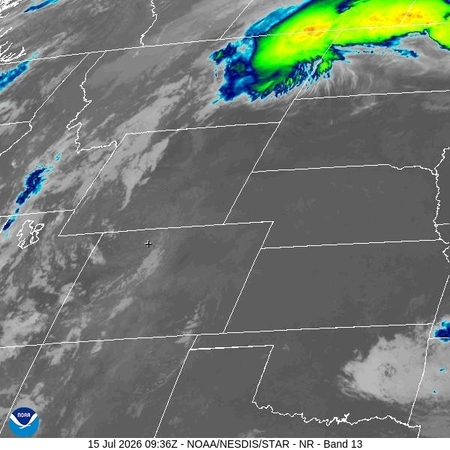
 Northern Rockies satellite movie
Northern Rockies satellite movieupdated 2:40 am Wed, 15 Jul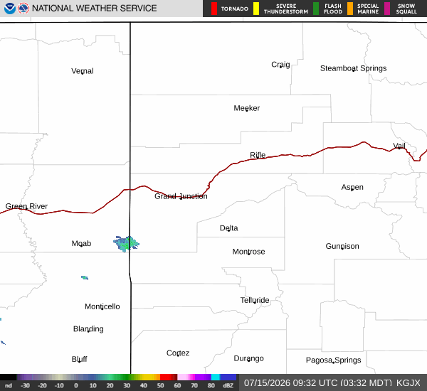 Colorado radar movie
Colorado radar movieLocal Temperatures, Winds & Precipitation
From Bob Adams airport:
Temp: 60 F Rel. Hum. 45%
Loading Steamboat Springs temp timeseries
Today: High: 65 F (12:15 am)
Low: 60 F (2:35 am)
Yesterday: High: 92 F (3:35 pm) Low: 52 F (5:55 am)
2 days ago: High: 94 F (4:55 pm) Low: 53 F (6:15 am)
Yesterday: High: 92 F (3:35 pm) Low: 52 F (5:55 am)
2 days ago: High: 94 F (4:55 pm) Low: 53 F (6:15 am)
Wind: W 5
Loading Steamboat Springs wind timeseries
Today: Max: 6 mph (12:15 am)
Yesterday: Max: 18 mph (4:15 pm) Gust: 31 mph (2:15 pm)
2 days ago: Max: 17 mph (4:55 pm) Gust: 24 mph (4:15 pm)
Yesterday: Max: 18 mph (4:15 pm) Gust: 31 mph (2:15 pm)
2 days ago: Max: 17 mph (4:55 pm) Gust: 24 mph (4:15 pm)
Temp: 58 F RH: 46%
Storm Peak Lab: 2:45 am Wed, 15 Jul 2026 MDT
Today: High: 59 F (12:00 am)
Low: 58 F (2:45 am)
Wind: SE 21 Gust: 25 mph
Storm Peak Lab: 2:45 am Wed, 15 Jul 2026 MDT (10 m wind)
Today: Max: 25 mph (12:30 am)
Gust: 32 mph (12:30 am)
Storm Peak Lab: 2:45 am Wed, 15 Jul 2026 MDT (12 m wind)
Precipitation Forecasts
Latest 18 hour accumulated precipitation forecast
from 1 am Wednesday to 7 pm Wednesday 15 Jul MDT

Latest 18 hour accumulated snow forecast
from 1 am Wednesday to 7 pm Wednesday 15 Jul MDT

Latest precipitation forecast - Storm Peak
Shown is the forecast precipitation for the next two days for the top of the Steamboat Ski Resort.
Meteorologists love to see how the forecast changes between successive model runs, so take advantage of my unique Previous forecast / Next forecast navigation at the bottom of the image. Careful - scales may change between forecasts.
Meteorologists love to see how the forecast changes between successive model runs, so take advantage of my unique Previous forecast / Next forecast navigation at the bottom of the image. Careful - scales may change between forecasts.
updated

Latest weather forecast - Storm Peak
Shown is the forecast precipitation for the next two days for the top of the Steamboat Ski Resort.
Meteorologists love to see how the forecast changes between successive model runs, so take advantage of my unique Previous forecast / Next forecast navigation at the bottom of the image. Careful - scales may change between forecasts.
Meteorologists love to see how the forecast changes between successive model runs, so take advantage of my unique Previous forecast / Next forecast navigation at the bottom of the image. Careful - scales may change between forecasts.
updated 2:43 am Wednesday 15 Jul MDT

Latest precipitation forecast - Steamboat Springs
Shown is the forecast precipitation for the next two days for Steamboat Springs.
Meteorologists love to see how the forecast changes between successive model runs, so take advantage of my unique Previous forecast / Next forecast navigation at the bottom of the image. Careful - scales may change between forecasts.
Meteorologists love to see how the forecast changes between successive model runs, so take advantage of my unique Previous forecast / Next forecast navigation at the bottom of the image. Careful - scales may change between forecasts.
updated
Latest weather forecast - Steamboat Springs
Shown is the forecast precipitation for the next two days for Steamboat Springs.
Meteorologists love to see how the forecast changes between successive model runs, so take advantage of my unique Previous forecast / Next forecast navigation at the bottom of the image. Careful - scales may change between forecasts.
Meteorologists love to see how the forecast changes between successive model runs, so take advantage of my unique Previous forecast / Next forecast navigation at the bottom of the image. Careful - scales may change between forecasts.
updated 2:43 am Wednesday 15 Jul MDT

Ensemble Forecasts
Weather forecast uncertainty lies in the chaotic nature of the atmosphere and in the imperfect representation of the atmosphere in numerical weather forecast models. Instead of making a single prediction of the most likely future weather, a set or ensemble of forecasts are produced to give an indication of the range of possible future states of the atmosphere. Ideally, the verified future atmospheric state should fall within the predicted ensemble spread, and the amount of spread should be related to the uncertainty (error) of the forecast.
Additionally, data are downscaled in order to increase the detail or resolution of the forecast. In this case, downscaling is the process of establishing statistical relationships between the large-scale model-predicted variables and small-scale local variables.
Meteorologists love to see how the forecast changes between successive model runs, so take advantage of my unique Previous forecast / Next forecast navigation at the bottom of the image. Careful - scales may change between forecasts.
Latest Utah Snow Ensemble Snow
The Utah Snow Ensemble is an 82-member ensemble for predicting snow over the contiguous western United States based on the ECMWF ensemble (ENS) and the US National Centers for Environmental Prediction Global Ensemble Forecast System (GEFS), with 51 members coming from the ENS and 31 from the GEFS. The forecasts are provided in 6-h intervals out to 240 hours (10 days). A summary of the data and methods and graphics is provided below.
Shown is the forecast snow for the next 10 days (240 hours) for most of the state of Colorado. The color scales are printed to the left of each panel.
Meteorologists love to see how the forecast changes between successive model runs, so take advantage of my unique Previous forecast / Next forecast navigation at the bottom of the image. Careful - scales may change between forecasts.
updated
Latest Utah Snow Ensemble Precipitation
The Utah Snow Ensemble is an 82-member ensemble for predicting snow over the contiguous western United States based on the ECMWF ensemble (ENS) and the US National Centers for Environmental Prediction Global Ensemble Forecast System (GEFS), with 51 members coming from the ENS and 31 from the GEFS. The forecasts are provided in 6-h intervals out to 240 hours (10 days). A summary of the data and methods and graphics is provided below.
Shown is the forecast liquid water for the next 10days (240 hours) for most of the state of Colorado. The color scales are printed to the left of each panel.
Meteorologists love to see how the forecast changes between successive model runs, so take advantage of my unique Previous forecast / Next forecast navigation at the bottom of the image. Careful - scales may change between forecasts.
updated
Latest Utah Snow Ensemble Plumes for Storm Peak Lab
The Utah Snow Ensemble is an 82-member ensemble for predicting snow over the contiguous western United States based on the ECMWF ensemble (ENS) and the US National Centers for Environmental Prediction Global Ensemble Forecast System (GEFS), with 51 members coming from the ENS and 31 from the GEFS. The forecasts are provided in 6-h intervals out to 240 hours (10 days). A summary of the data and methods and graphics is provided below.
Shown is the forecast snow for the next 10 days (240 hours) for most of the state of Colorado. The color scales are printed to the left of each panel.
Plumes refer to a time series of each model run at a specific loaction, in this case the precipitation forecast for the Storm Peak Lab near the top of Mt. Werner. Generally, mid-mountain snowfall at the Steamboat Ski Area is about 3/4 of the summit snowfall.
Times on the bottom axis are in UTC, or Coordinated Universal Time, which is the time at 0 degrees longitude. It used to be referred to as Zulu time, hence the Z designation in the charts, and does not adhere to daylight savings time, so it is 7 hours ahead of MST (0Z refers to 5pm MST the day before and 12Z refers to 5am) and 6 hours ahead of MDT.
Meteorologists love to see how the forecast changes between successive model runs, so take advantage of my unique Previous forecast / Next forecast navigation at the bottom of the image. Careful - scales may change between forecasts.
updated
Latest Point Forecasts
Latest NAM Precipitation for Mt. Werner
Point forecast for the top of the Steamboat Ski Area on Mt Werner from the National Centers for Environmental Prediction (NCEP) North American Mesoscale Forecast System (NAM). Model output available every third hour.
All times local
Meteorologists love to see how the forecast changes between successive model runs, so take advantage of my unique Previous forecast / Next forecast navigation at the bottom of the image. Careful - scales may change between forecasts.
All times local
Meteorologists love to see how the forecast changes between successive model runs, so take advantage of my unique Previous forecast / Next forecast navigation at the bottom of the image. Careful - scales may change between forecasts.
updated
Latest CAIC Precipitation for Mt. Werner
Point forecast for the top of the Steamboat Ski Area on Mt. Werner from the Colorado Avalanche Information Center
All times local
Meteorologists love to see how the forecast changes between successive model runs, so take advantage of my unique Previous forecast / Next forecast navigation at the bottom of the image. Careful - scales may change between forecasts.
All times local
Meteorologists love to see how the forecast changes between successive model runs, so take advantage of my unique Previous forecast / Next forecast navigation at the bottom of the image. Careful - scales may change between forecasts.
updated 1:42 am Wednesday 15 Jul MDT

Compared to Average
Yampa River flow · Steamboat
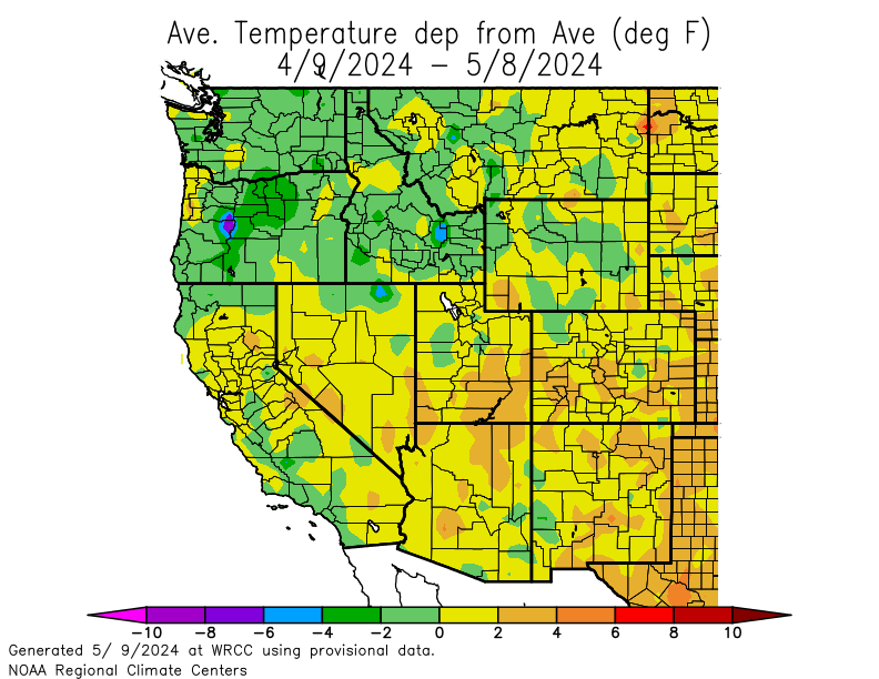
SNOTEL - River basin temperature departure from average for the past 30 days
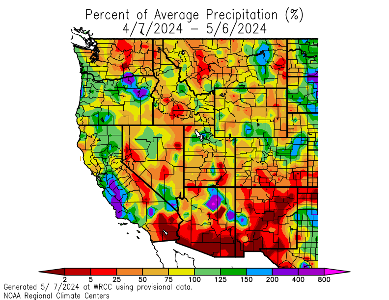
SNOTEL - River basin snow water content as percent of average for the past 30 days
SNOTEL - River basin temperature departure from average since October 1

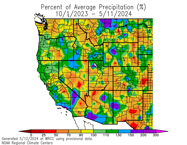
SNOTEL - River basin snow water content as percent of average since October 1
>
||
<


