Christmas Day storm brings snow and cold temperatures
Tuesday, December 23, 2014






This last storm was disappointing for us, as most surrounding areas received snow in the 18-36” range. I mentioned in the last forecast that any warming aloft is cause for concern. Indeed, freezing rain started on the hill about 2pm Sunday afternoon after a morning of heavy snowfall, which was eerily similar to the Opening Day Ice Storm. Luckily, there was minimal damage to the snowpack this time around, though the lack of accumulating snowfall surely hurt.
Unfortunately, I don’t have a good explanation of why we are getting these very unusual freezing rain events. I’ve sent emails to the National Weather Service and Colorado Avalanche Information Center asking for their opinions, but they are so concerned with future operations that the resources to investigate past events are scarce. I mentioned in the last storm forecast that warming aloft causes my forecasts to lean pessimistic, and apparently I need to increase that negative bias in the future.
After unsettled weather for today and tomorrow, attention turns to the impending Christmas Day storm, currently located in the Gulf of Alaska. This storm splits as it enters the west coast late Wednesday, but a considerable amount of energy is forecast to be in the southern branch as this portion of the storm traverses the Great Basin. Light snow should start around midday on Christmas and we should have a burst of heavy snow when the front moves through later that afternoon or evening. Most of the energy will remain south of our area, but we should continue to receive lighter snow behind the front, leading to 4-8” by the Friday morning report.
It does appear the flow will eventually turn to the northwest sometime on Friday, and that may allow for snowfall to keep accumulating through the day under much colder temperatures. Coincidentally, after the just-passed storm earlier in the week inundates the East Coast, it will help form the Hudson Bay vortex, which is one lobe of the Polar Vortex which received much media attention last year. The counter-clockwise rotation around this vortex allows the bitterly cold arctic air in the Canadian Plains to move southward, enhanced by energy entering the west coast from the Pacific.
Some of this Pacific energy will trail the Christmas storm and move west of us later Friday night, keeping snow showers going through early Saturday morning and leaving another 2-5” for the morning report before a break later in the day. Additional minor waves keep the unsettled and cold weather present from Sunday through midweek, leading to a general forecast of 1-4” for the Monday through Wednesday morning reports.
Current forecasts have a more significant wave bringing a threat of heavier snows around New Years Eve day, but the models are struggling with the westward and southern extent of the cold air, lending uncertainty to that forecast.
Unsettled weather turns stormy by Sunday
Friday, December 19, 2014
The current unsettled weather pattern continues with periods of light snow ending by this afternoon. A transient ridge will move over the area Saturday, but will be quickly followed by storminess starting Sunday and lasting through Tuesday.
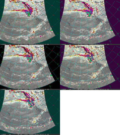 Currently, what meteorologists are now calling an atmospheric river is inundating the Pacific Northwest, as shown in the infra-red satellite animation to the right. This is simply a relatively narrow and long fetch of concentrated moisture in the atmosphere. The Pineapple Express, for example, is the well-known moniker given to an atmospheric river originating around Hawaii.
The current atmospheric river with roots in the northern Pacific will move towards our area and begin producing precipitation around Saturday night. Even though we will be in strong and moist northwest flow, current model trends have the atmosphere warming during the day Sunday with very windy conditions, which throws a wrench into the previously very bullish forecast. My experience is that our forecast becomes far more uncertain, and generally leans pessimistic under a warming atmosphere. Our most recent experience with a similar scenario lead to our freezing rain event; we started out with moderate to heavy snowfall as temperatures rose in the morning, transitioning to freezing rain as the warming and upward motion associated with that warming ceased. I am not suggesting that we will see another freezing rain event as I’m STILL not sure what happened there, but wanted to highlight the uncertaintly present.
So, I am now very uncertain about snow amounts during the day. However, cooling does begin by later Sunday, and that increases confidence that heavy snows increase. Winds will stay very strong through the day Monday, continuing the moderate to heavy snowfall until the intensity drops off near the end of the day. Lighter snowfall, however, will continue overnight.
Snowfall from Sunday through Monday will likely be heavy, with what happens during the day Sunday being a bit of a wildcard. Travel will also be very difficult during this time period. At this point, I would guess maybe an inch or two by the Sunday morning report, with 5-10” reported Monday morning. Cooling increases later Monday, decreasing the density of the snow and increasing accumulations, possibly leading to another 4-8” by Tuesday morning.
Wednesday will be chilly with the 1-4” reported in the morning occurring during the day Tuesday. Models have trended significantly stronger with the ridging behind this storm, leading to warming conditions and weakening the storm earlier advertised for Christmas Day. The storm still looks to be significant though with snow increasing during the day Thursday and lasting through Friday morning, leaving another 6-12” by the morning report.
Four events to influence our weather over the next week
Tuesday, December 16, 2014
Now that the official and well-forecasted 19” storm total reported at mid-mountain is behind us (after the Steamboat ski area reported 2” this morning), attention turns to the unsettled pattern forecast to persist for at least the next week. Currently, light snow is falling and will continue through the early afternoon before ending. I expect accumulations of only an inch or two due to the brief duration of this first event.
Concurrently, a split trough has entered the west coast, and it looks like the southern part may produce precipitation over our area as soon as tomorrow and lasting through Friday. There is surprising disagreement between the American short-range NAM and the American medium-range AVN as to if this precipitation will occur for our area as the NAM is dry for us. I’m inclined to side with the moister AVN since that model tends to do produce a better forecast for our area in moist northwest flow with falling temperatures.
However, this model also tends to overpredict precipitation in the pre-frontal environment when southwest flow dominates, so I expect only minimal accumulations, if at all, during the day tomorrow. A weak front passes through near the end of the day, and that is when I expect snowfall to increase and become steadier.
Temperatures rise on Thursday during the day and this will lessen the snowfall. A trailing weak wave passes through Thursday night and should keep light snowfall going during the day Friday. At this point, I would expect around 4-8” between Wednesday and Friday afternoons.
A very brief break Friday night into Saturday morning before another splitting wave is forecast to bring another round of light snow starting Saturday afternoon and lasting through Sunday morning, likely leaving only several inches by noon Sunday.
Another very brief break that may only last Sunday afternoon before a period of moist northwest flow sets up over our area by Sunday night. Snows will be mostly light through Tuesday, though an enhancement may occur later Monday as some cool air moves over the area.
Models have been somewhat consistent in forecasting a major storm to cross the west coast midweek. This is another splitting storm, but this time the split occurs well off the coast and the dominant northern branch phases with some bitterly cold arctic air currently over northern Canada. The interaction between the Pacific and Canadian airmasses is forecast to lead to a major storm around Christmas for the northwestern US and Rockies. Current timing has heavy snows and plunging temperatures for us on Christmas Day, though of course that is subject to change as that forecast is a week away. In fact, the very latest European ECMWF has more interaction between the Pacific and arctic airmasses over the Gulf of Alaska early next week, and that might draw more cold air into the storm and change its trajectory.
Earlier model runs has this cold air remaining over our region for a while, but now, after forecasting a still cold post-Christmas weekend, they are forecasting warming temperatures by early in the next workweek.
Classic Powder Day finally arrives!
Monday, December 15, 2014
Another 13” at 5 am this morning on top of the 4” reported yesterday morning has buried what was left of the Opening Day Ice Crust. In fact there was about 8” of heavy and dense powder by yesterday (Sunday) afternoon with another 10” of very light and dry powder on top of that which fell overnight. Plus, we had some Steamboat Magic this morning with another 3 or 4 inches falling by noon today. Of course, that will be reported tomorrow morning, but it looks like the storm delivered about 20” or 21” of perfect powder to the Steamboat Ski Area.
First run down Norther clued me in to just how good this day was going to be. Though mounds of bumps were visible, they were barely felt as I floated over and between them. An early chair up Four Points lead me to untracked turns down Tornado directly under the Storm Peak liftline, which was as good as you might imagine!
But what really shined was the first run down Closets. Though I was very aware and careful of what lies underneath, the upper 2/3 of the run skied bouncy and effortlessly. The lower third of the run still needed a bit more coverage to completely cover the downed tree hazards, and forced some slower and more deliberate turns.
Hustling back to Storm Peak via Duster and Lower Rainbow lead to another virtually untracked line down Shadows. Since the hazards in the aspen need a bit less snow to cover than in the pine, the lower third skied well. In fact, that run and the next in the same area had me down to Duster before I needed to stop and rest, which is always a sign of great powder skiing.
Still being careful in the trees, great powder shots were found off of West Side, off of Rolex and even Under the Rainbow. Twilight was far more popular with other skiers and boarders, but still had some swaths of untracked as late as noon, especially near the bottom.
And, as I rode Elkhead to return home, I noticed a flood of skiers on Lower Shadows for the first time this season, forcing another ride up Storm Peak to sample the newly opened terrain. Great deep and steep skiing on that pitch; so good in fact that I continued to ski this for another 3 runs. By 2:30 pm, my legs were begging for rest, but not before skiing freshly opened Upper Valley View on the way to the bottom.
More storminess in the forecast for this week, and likely beyond, and just in time for the Christmas visitors.
Pattern change brings snow this weekend
Thursday, December 11, 2014
The current stretch of warm and dry weather looks to change by mid-weekend as a splitting storm currently pummeling California moves eastward. Another nice day on Friday will be followed by increasing cloudiness on Saturday as the storm enters the Great Basin. Precipitation for us may start as early as Saturday afternoon, or may hold off till later Saturday night or early Sunday morning.
The strongest part of the storm will pass to our south, but we should do well in the cool and moist northwest flow behind the main energy center of the storm during the day Sunday. Furthermore, models now have a portion of the northern part of the split storm hanging back over southern Idaho or southwestern Wyoming and enhancing snowfall again by late Sunday night or Monday morning.
Forecasting snow amounts is difficult due to the strongly evolving nature of this storm, but currently I would expect only light snowfall in the 1-4” range to be reported Sunday morning. Periods of moderate to sometimes heavy snowfall will likely occur during the day Sunday and overnight, leading to accumulations of 5-10” by Monday morning. And additional 1-4” will likely fall during the day Monday to be reported Tuesday morning.
After a break Tuesday, the progressive forecast from the American GFS model last week wins out over the forecast from the European ECMWF. Interestingly, this is the second time the this winter the GFS showed superior skill in the medium range, and is something to take note of moving forward.
The progressive forecast moves another splitting storm over our area by midweek. Again, there will be uncertainty with respect to snowfall amounts, but the storm will likely peak around later Wednesday before exiting the area on Thursday. And the storm train will continue with another similar wave timed for the following weekend.