Nice start to the weekend to precede Sunday showers
Thursday, February 26, 2026
Mostly cloudy skies are over Steamboat Springs early this Thursday afternoon, with temperatures around 40 degrees in town, on the way to the mid-forties, and 20 degrees at the top of the Steamboat Ski Resort. The atmospheric river that brought 6” of dense snow to mid-mountain on Wednesday morning and around an inch of rain in town is receding, bringing some sun to the area this afternoon. Beautiful weather will follow on a warm, mostly sunny Friday and Saturday ahead of another round of warm precipitation for Sunday.
Two large eddies of low pressure flank a ridge of high pressure near the Dateline, while a trough of low pressure extends southward from the Great Lakes. The western-most eddy is forecast to strengthen and move eastward, destroying the Dateline ridge and forcing the downstream eddy eastward toward the northern California coast by Sunday.
A transient and shallow ridge of high pressure will build over the West ahead of this eddy, bringing mostly sunny skies on Friday and most of Saturday, with high temperatures in the upper-forties on Friday and around 50 degrees on Saturday, well above our 39-degree average.
Energy and moisture ejecting from the eddy will cross the Great Basin on Saturday, reaching our area as early as Saturday afternoon and bringing increasing high clouds. Fortunately, this won’t be a windy storm, but unfortunately, it will be another warm storm with snow levels around 8,500′, bringing rain to the Yampa Valley and more dense snow at and above mid-mountain on Sunday.
What remains of the eddy is forecast to cross the Great Basin on Monday, providing a break in the precipitation, which is expected to restart later Monday or Tuesday as the storm approaches and then moves across Colorado.
So enjoy the nice couple of days to start the weekend, and I’ll have more details on the approaching storm, including mid-mountain snowfall guesses, in my next regularly scheduled weather narrative on Sunday afternoon.
Gorgeous weather ahead of warm, wet and windy midweek storm
Sunday, February 22, 2026
A gorgeous day is over Steamboat Springs late this Sunday morning with sunny skies and temperatures around 20 degrees at all elevations, rising to near 40 degrees in town and upper twenties at the top of the Steamboat Ski Resort. Even warmer temperatures on Monday will persist through the rest of the week, despite a windy storm on Wednesday that will be accompanied by significant precipitation, with, unfortunately, mostly rain in town.
 After receiving 21” of snow at mid-mountain and an unofficial 28” up top from Tuesday night through Friday, a ridge of high pressure is over the West, sandwiched between a large eddy of low pressure over the eastern Pacific and a broad trough of low pressure over eastern North America, bringing a Nor’easter to the Northeast today.
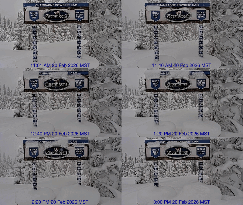
I say unofficial since Steamboat inexplicably reported only 4” up top on the Saturday morning ski report, even though the upper-mountain Powdercam showed an incredible 10” of snow falling between 11 am and 3 pm on Friday, highlighted by a couple of times when 1” of snow fell in only 20 minutes!
While I expected some additional snow on Friday night, the drying atmosphere had other plans, stopping the snowfall early in the evening and bringing a beautiful, crisp winter day to Steamboat Springs on Saturday.
Temperatures will warm under the ridge of high pressure, with the high reaching 40 degrees in town today and the mid-forties on Monday, above our slowly rising average of 37 degrees, with sunny daytime skies. These high temperatures in the 40s will persist through the workweek.
Meanwhile, a wave of energy rounding a ridge of high pressure over the Dateline has split over Alaska, with some energy elongating the eastern Pacific eddy to the southwest, and some continuing southeastward across British Columbia. The eddy extends far enough south to ingest an atmospheric river of moisture from near Hawaii, the so-called Pineapple Express, that will combine with the moisture now spinning around the eddy, which is impacting the Pacific Northwest.
Additional waves of cold air moving across British Columbia will flatten the western ridge of high pressure through midweek, guiding the Pinapple Express over the ridge and toward our area by later Tuesday. Expect increasing clouds and breezes on Tuesday, followed by possible late-day precipitation with snow levels around 8,000′.
Snowfall timing on the hill is uncertain due to the elongated trough over the eastern Pacific splitting, but the windy conditions are not. Expect sustained westerly winds up to 35 mph on Wednesday, with gusts up to 60 mph. Snowfall on the hill could occur anytime between Tuesday night and Thursday morning, and is dependent upon whether the atmospheric river is incorporated into the northern part of the split or stays ahead of it, with 5-10” of wet, dense snow likely falling at mid-mountain during the storm.
The ridge of high pressure is forecast to rebound behind the storm, bringing nice weather back to our area either early Thursday or later in the day. This nice, and sadly warm, weather will extend into the weekend, with unsettled weather advertised to reappear late in the weekend or early in the following workweek.
So enjoy the gorgeous start and end to this week, hope for more moisture and colder temperatures than forecast, and I’ll have additional details on the possible return of moisture around the end of the weekend in my next regularly scheduled weather narrative on Thursday afternoon.
Snows to continue into Saturday morning
Thursday, February 19, 2026
Snow showers have temporarily ended over Steamboat Springs late this Thursday afternoon, with temperatures in the upper teens in town, after reaching a high of 23 degrees, and only 2 degrees at the top of the Steamboat Ski Resort, after reaching a high of 4 degrees. Including the 4 inches this morning that fell after the ski report, 17” of snow has been reported at mid-mountain since Tuesday morning, with additional accumulations expected from Friday into Saturday morning. Sunny skies return Saturday afternoon and last into the next workweek, with the current cold temperatures moderating by Sunday.
The last wave in this storm cycle, which started on Tuesday, has crossed California and entered southern Nevada and will be moving over Colorado on Friday afternoon. After a brief break in the weather tonight, light snow showers should restart early on Friday ahead of the wave, ramping up through the morning and becoming moderate to even heavy at times in the afternoon as the storm crosses the Divide.
We can expect 3-6” of snow at mid-mountain during the day, with another 2-5” overnight as showers continue in the favorable cold, moist, and unstable northwest flow behind the storm. Most of the storm should be over by midnight, though showers producing another inch or two of fluffy, low-density snowfall could continue into Saturday morning ahead of a mostly sunny afternoon.
The cold temperatures will stick around through Saturday, with high temperatures in town staying in the twenties and below our 36-degree average until a mostly sunny Sunday. Low temperatures in town will also stay below the 9.5-degree average until a mostly sunny Monday.
Meanwhile, a powerful storm is forecast develop and split in the Gulf of Alaska through the weekend, sandwiched by a ridge of high pressure building near the Dateline and another over the West. The western ridge will bring a nice and warm start to the workweek, with unsettled weather possibly returning to our area around midweek as energy and moisture from both parts of the Gulf of Alaska storm and an atmospheric river interact with the ridge.
So enjoy the appropriate mid-winter weather to start the weekend, and the nice weather that follows, and I’ll have more details about the possibly unsettled midweek weather in my next regularly scheduled weather narrative on Sunday afternoon.
Late weather narrative today
Sorry, but real work has arrived with real powder, so expect the weather narrative early this evening when I return from escaping to ski this afternoon.
Winter weather to return starting Tuesday
Sunday, February 15, 2026
Some sun is filtering through high clouds this Sunday at noon in Steamboat Springs, with temperatures in town at 35 degrees, on the way to the mid-forties, and 25 degrees near the top of the Steamboat Ski Resort. The clouds are in advance of a strong storm system that will bring proper winter weather back to our area starting on Tuesday and lasting through the workweek, replete with high winds, sharply falling temperatures, and one to two feet of mountain snowfall.
An eddy of low pressure incorporating an atmospheric river from just north of Hawaii has formed off the northern California coast, while a wave of energy slides down the British Columbia coast. This wave will ingest frigid air rotating southwestward through western Canada and strengthen, interacting with the eddy on Monday and forcing it eastward across central California.
These two systems will provide a one-two weather punch for our area, the first on Tuesday as the former eddy moves across, and the second, later Wednesday, when most of the trailing storm follows. Snowfall will continue between and after these storms, lasting from Tuesday morning through Thursday morning, with additional, but likely lighter, snowfall on Friday.
Ahead of the storms, pleasant weather with high clouds and filtered sun will be with us today and on Washington’s Birthday, with high temperatures today in the mid-forties, well above our 34-degree average, and around 50 degrees on an even warmer Monday, despite the clouds.
Precipitation should break out after midnight on Monday, with a rain-snow mix in town changing to snow Tuesday morning. There may be some snow for the mid-mountain morning report, and an additional 1-4” during the day with high temperatures in the low-twenties as the first storm passes overhead. Unfortunately, this will be accompanied by strong westerly winds gusting to as high as 70 mph, possibly affecting lift operations.
Another 3-6” could fall overnight, leaving 4-10” of snowfall for the Wednesday morning mid-mountain ski report. Winds will decrease but remain quite strong, with 50 mph gusts possible and high temperatures falling into the upper teens, along with another 3-6” of new snow.
Meanwhile, the second storm will be forced eastward on Wednesday by an upstream wave now rounding a ridge of high pressure over the Dateline, taking a similar track and eventually bringing additional snowfall to our area on Friday.
So snowfall will continue Wednesday night, possibly becoming heavy at times as a strong cold front associated with the second wave moves through. Combined with the snow during the day on Wednesday, we could see 6-12” reported at mid-mountain by Thursday morning, with more, as usual, up top. Winds will decrease but still remain breezy, and high temperatures up there may not make it out of the single digits, with high temperatures in town finally below average and in the mid-twenties.
There may be a break in the snowfall on Thursday afternoon as a shallow ridge of high pressure builds behind the departing storm and ahead of the final wave. There is some uncertainty regarding snowfall amounts, which could be in the 3-6” range, though not the cold air, as high temperatures will be similar on Thursday, Friday, and a likely sunny Saturday.
Enjoy the mild weather through Washington’s Birthday, and the recalcitrant winter weather that follows, and I’ll have more details on what is looking like a beautiful weekend in my next regularly scheduled weather narrative on Thursday afternoon.


