
Seventy degree temperatures to last through the weekend

Thursday, October 10, 2024
Temperatures reached seventy-six degrees this Thursday mid-afternoon in Steamboat Springs under mostly sunny skies. This weekend, we will see continued warm temperatures more representative of early September than mid-October, along with periodic smoke from the Lake Fire in the Unitas. The mostly sunny skies may be interrupted by clouds early Friday and again later Sunday as a small storm approaches.
A stubborn ridge of high pressure responsible for our gorgeous fall weather still extends from the Mississippi to the West Coast. High clouds behind a storm moving across the Canadian Plains may move overhead tonight through Friday morning, but mostly sunny skies should return by Friday afternoon.
There may be a couple of pulses of smoke over our area early Friday and again Friday night, as shown by the NOAA Smoke Plume model. This model is run four times a day through 48 hours, so be sure to check that guidance for the latest forecast.
A storm now moving through the Gulf of Alaska is forecast to split, with the southern end forming an eddy that crosses the Oregon-California coast on Saturday. The eddy then begins to meander around the Great Basin by Sunday, and we may see some moisture drawn northward by the southerly winds ahead of the eddy. Clouds should increase by Sunday afternoon with even a shower possible later in the day or evening, though that would likely produce more wind than rain due to the dry lower atmosphere.
The eddy is forecast to move very little through the beginning of the workweek, and we may see some clouds and low shower chances again on Monday. The eddy is forecast to eventually be ejected to our northeast around midweek by another colder and wetter storm currently developing over the Aleutian Islands.
But we’ve already seen several storms that looked promising a week in advance fizzle by the time they approached our area, so enjoy another beautiful weekend and check back to my next regularly scheduled weather narrative on Sunday afternoon for the latest details on the next evolving storm.
Record breaking September in the books
Sunday, October 6, 2024
Sunny but hazy skies and temperatures approaching sixty degrees, again on their way to the low seventies, are over the Steamboat Springs area this Sunday noon. Smoke from the Lake Fire in the Unitas will come and go during the workweek as high temperatures hover in the low to mid-seventies, along with occasional clouds as Pacific moisture sneaks into the area. The benign weather will allow more space in this weather narrative to list some of the Steamboat Springs temperature records broken in September.
The temperature records are due to a stubborn ridge of high pressure established in mid-September that is still centered over the West. Not only were several high temperature records set in September, but we just had another one this last Friday as the 81 F recorded at the official weather station behind the high school broke the old record of 80 F set in 1945.
The highlight of September occurred around last weekend of the month when the high temperature reached 86 F on Friday, surpassing the old record of 83 F set in 2001. And the 85 F records set on both Saturday and Sunday broke the previous 83 F records set in 2010 on Saturday and 2019 on Sunday.
Combined with the unseasonably warm temperatures preceding and following that weekend, the last week of September was the hottest measured since record-keeping began in Steamboat Springs in February of 1893. These seven days broke three records and tied two, averaging a high temperature of 82.9 F compared to the old record of 81.7 recorded in 2001. The ten days straddling the start of October between September 26 and October 5 averaged a high temperature of 81.9, which also broke the previous record of 79.3 set in 1897.
Though we had some cool days, including a high temperature of only 61 F on Tuesday, September 17, the average high temperature of September was the ninth hottest on record, with an average of 78.4 F, well short of the 82.1 F set in 1897. In fact the three hottest Septembers were in 1897, 1896 and 1893. Imagine moving here as a settler in the early 1890’s and experiencing the three hottest Septembers in the next 130 years, and counting! Trying to plan for the future years based only on that short-term experience could have proven fatal.
If the average daily temperature is considered, which averages both the high and low temperature of the day, September moves up the list as the fourth warmest on record at 58.1 F, compared to the record of 58.9 set in 1998.
The temperature records look to be safe this week as high temperatures are forecast to be in the mid-seventies, especially the 89 F record set on October 9, 1910! That was also the hottest temperature recorded in October, followed by the next hottest of 84 F set two days earlier on October 7, 1910 and tying the high temperature set two years earlier on October 8, 1908. And 1908 had some warm days, as the highest September temperature of 93 F was set on September 7.
While the mid-seventies sounds cool relative to the high-temperature records, it is still around ten degrees above our average of 64 F. Some Pacific moisture may sneak under the dominant western ridge of high pressure for some occasional clouds, but smoke from the Lake Fire burning in northeast Utah may prove to be the most noticeable element of the workweek weather. Check the NOAA Smoke Plume model, also available via the See the latest NOAA smoke model forecast link under the Purple Air widget on the SnowAlarm home page for the latest smoke forecast. The model is run four times a day through forty-eight hours, and currently predicts some smoke abatement on Monday before another pulse approaches our area on Tuesday.
There was earlier hope of a storm around next weekend, but the weather forecast models have backed off that prediction for now. So enjoy another warm fall workweek, and check back for the latest details on the coming weekend weather in my next regularly scheduled weather narrative on Thursday afternoon.
Another beautiful weekend ahead
Thursday, October 3, 2024
Mostly sunny skies and comfortable temperatures approaching seventy-five degrees are over the Steamboat Springs area this Thursday midafternoon. We’ve had nothing but beautiful weather since fall officially arrived almost two weeks ago, and that looks to continue through this weekend and into the following week. Near-record temperatures approaching eighty degrees are expected for Friday ahead of a storm moving through the northern Rockies on Saturday. Expect a breezy or even windy Saturday afternoon thanks to a grazing cool front that will knock temperatures back toward the low seventies.
A ridge of high pressure over the West will be pushed eastward by a storm forecast to pass through Vancouver on Friday. Breezes will increase from the west and southwest ahead of the storm, allowing temperatures to approach the record high of 80 F set in 1943. I suspect we were close to reaching or exceeding temperature records last weekend, but those official data are still awaiting publication.
Though winds will subside overnight, some cloud cover and leftover breezes may be enough to keep our low temperatures five to ten degrees above our average of 29 F. And even though high temperatures will fall back into the low seventies for Saturday and Sunday thanks to breezes out of the west and northwest, which will be strongest on Saturday, that is still almost ten degrees above our average of 65 F.
There is still plenty of lower-elevation color around, so get out and enjoy another warm and sunny weekend. We may see some moisture sneaking under the rebuilding ridge of high pressure over the West around midweek, though the weather forecast models have recently diminished those chances. Otherwise, a more promising storm may be strong enough to displace the high pressure ridge over the West by the following weekend. I’ll have more details on those possibilities in my next regularly scheduled weather narrative on Sunday afternoon.
Spectacular weather to continue this week
Sunday, September 29, 2024
Temperatures are around seventy degrees, again on their way into the low-eighties, under mostly sunny skies this Sunday noon in Steamboat Springs. Despite some cooling starting tomorrow, mostly sunny skies and high temperatures in the mid to upper-seventies will persist through the work week and into the following weekend.

 The 84 F high temperature in town last Wednesday broke the previous record for the date set in 2015 by one degree. Even though the official data are yet to be published by the weather station near the high school, we should be challenging the previous records of 83 F set in 2001 on Friday, 2010 on Saturday and 2019 today.
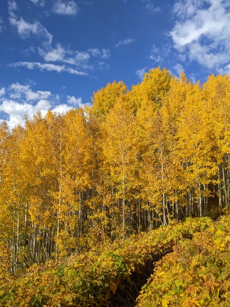
The warm sunny days and clear crisp nights with lows in the mid to upper-thirties and low forties, between five and ten degrees above our average of 31 F, have allowed quite the color spectacle to appear over the area, as shown by some recent photos.
The current weather is due to a ridge of high pressure over most of the West. An eddy of low pressure over central California has pulled a modicum of moisture northward toward our area, while a quick-moving wave of low pressure has moved through Vancouver.
We may see more afternoon clouds today and perhaps even an insignificant afternoon or evening shower ahead of the Vancouver storm which is forecast to sweep across the northern Rockies on Monday.
Ahead of a cool front from the storm tickling our region late Monday or early Tuesday, breezes from the west will pick up later today and especially Monday, perhaps shaking some leaves off the colorful display. High temperatures will drop into the upper-seventies on Monday and the mid-seventies on Tuesday, still well above our average of 68 F.
The grazing cool front will be our only weather this week, with mostly sunny skies and mid-seventy temperatures persisting through the work week and into the weekend. There was a chance for a pattern change around next weekend, but current weather forecast models have the western ridge of high pressure deflecting or weakening any incoming Pacific weather systems.
So enjoy the summery weather ahead, and check my next regularly scheduled weather narrative on Thursday afternoon to see if this gorgeous weather persists through next weekend.
Gorgeous weather to continue through the weekend
Thursday, September 26, 2024
Mostly sunny skies and eighty-one-degree temperatures are over the Steamboat Springs area late this Thursday afternoon. This gorgeous weather will continue through the weekend, leaving a simple and short weather narrative for this afternoon.
A ridge of high pressure is currently over the western two-thirds of the country while rapidly intensifying Hurricane Helene approaches the Big Bend region of Florida. Eventually, the tropical storm will merge with an eddy of low pressure over the Mississippi River Valley, with that interaction lasting through at least the weekend, but that will not affect our weather.
Instead, a quick-moving and dry storm that moved across the northern Rockies today has squashed the northern part of the ridge and carried a modicum of moisture overhead for some sparse clouds today. Another similarly dry but stronger storm is forecast to cross the Pacific Northwest coast on Sunday, keeping the sparse moisture around for some afternoon clouds, but not affecting the mostly sunny skies with high temperatures in the low-eighties. This is over ten degrees above our average of 69 F and might threaten the record temperature of 83 F set in 2001 on Friday, 2010 on Saturday and 2019 on Sunday.
And even though the average low temperature has fallen to freezing, the mild air mass under the ridge of high pressure will moderate low temperatures and keep them in the mid to upper-thirties and low-forties.
The fall colors are nearing a peak above 9000′, if not already there, so get out and enjoy the stellar weekend that will feel more like summer than fall. That Pacific Northwest storm may induce some afternoon breezes from the west as soon as Sunday afternoon ahead of a grazing and dry cold front late Monday or early Tuesday. I’ll have more details about that in my next regularly scheduled weather narrative on Sunday afternoon.


