
Some warming to follow near record low temperatures on Monday

Sunday, January 19, 2025
The Steamboat Springs temperature finally broke above zero degrees under cloudy skies early this Sunday afternoon, though the mountain-top temperature has only reached minus five degrees. The deep freeze will only deepen as a final push of cold air tonight brings some snow and perhaps the record coldest high temperature for the date on Monday, which peaked at eight degrees in 1937. And if skies clear by Tuesday morning, the record low temperatures of -34 F in 1935 could be in jeopardy. Warmer but still below-average temperatures will persist until Friday when more seasonable, and reasonable, temperatures occur before another possibly cold storm around next weekend.
Sadly, the conservative, rather than optimistic, forecast from last Thursday’s weather narrative verified when 3” was reported at mid-mountain Saturday morning and 5” at the summit, in addition to 2” reported at both locations this morning. Using the optimistic model to make a reasonable snowfall guess is problematic as I have found no reliable indicator to weigh its outcome, making the model most useful in hindsight.
But the cold air for this weekend was never in doubt thanks to a sharp ridge of high pressure over the West Coast extending to the North Pole and directing air from a vortex of bitterly cold air centered west of Hudson Bay over our area. A final wave of cold air will pass through tonight, leaving another 1-4” on the hill and threatening our coldest January 20th high temperature of 8 F recorded in 1937. The sun may appear in the afternoon, making it feel marginally warmer, but if skies stay clear we could be threatening our low temperature for the date of -34 F recorded in 1935, unreasonably below our average of 5 F.
A strong storm off the Aleutian Islands is forecast to move eastward, also pushing a leading storm and the weakening West Coast ridge of high pressure ridge eastward. We should see mostly sunny skies for Tuesday as what is left of the ridge moves overhead, though after such a cold start, temperatures may struggle to reach 10 F, well below our average of 30 F.
The weaker storm in advance of the Aleutian storm will move through our area on Wednesday, bringing clouds, a chance of flurries and slightly warmer but still well below-average temperatures. You know the previous morning was cold when the National Weather Service forecast for Wednesday morning says “Not as cold. Lows 10 below zero to 20 below”!.
Temperatures will only slowly moderate for Thursday and Friday, with lows in the minus teens to the minus single digits and highs from the teens to the twenties. Friday looks like the warmest day of the week and quite pleasant ahead of that Aleutian storm forecast to bring some snow and more cold next weekend.
Dress especially warmly for the start of the week, the National Weather Service has an Extreme Cold Watch from Monday evening through Tuesday morning, renamed from an Extreme Wind Chill Watch this season, and expect well below-zero mornings through most of the workweek. Check back for more details on the possible weekend storm in my next regularly scheduled weather narrative on Thursday afternoon.
Near-record cold arrives with some snow Friday night
Thursday, January 16, 2025
Bluebird skies are over Steamboat Springs late this Thursday morning, and while temperatures are in the mid-teens in town, they have done nothing but warm from the mid-teens yesterday afternoon to the upper-twenties near the top of the Steamboat Ski Resort. Soak up the beautiful day today as Friday marks a transition to a frigid, near-record-cold arctic outbreak that will engulf our area by Friday night and last through the long Martin Luther King Jr. weekend. Snow showers will accompany the front and continue behind it, and though there is limited moisture, surprisingly high snow totals might occur due to its very low density.
An eddy of low pressure off the southern California coast trapped under a ridge of high pressure over the West Coast has turned our mountain-top winds from the cold northwest to the warm southwest. While this has warmed the upper elevations, the Yampa Valley will only reach around five to ten degrees below our normal high temperature of 29 F as a stout temperature inversion, where air warms as elevation increases, blocks the warm air aloft from mixing down.
Clouds should increase on Friday, and if they appear before sunrise our low temperatures may warm above our average of 5 F for the first time in almost a week as they act like a blanket to insulate the surface. Otherwise, expect subzero low temperatures to start the day again.
The arctic cold front looks to pass through our area within several hours of sunset Friday. While moisture is limited in the very cold air, snow ratios could be inflated, similar to the monster accumulation last Saturday night, due to the unstable air and ideal temperatures for dendrites, the classic branched snowflake, to form.
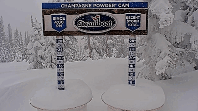
While the conservative forecast calls for 3-6” of snow by the Saturday morning report, with an additional 1-4” during the day, a particularly optimistic model has over a foot by the report and two feet by the evening. This sometimes-right but often-wrong model was closest in predicting last weekend’s storm, so keep an eye on the mid-mountain Powdercam and the upper-mountain Powdercam!
Temperatures will plummet behind the front, only reaching around zero degrees up top on Saturday and around ten degrees in town. Overnight lows for Sunday could be in the minus-teens at all elevations, with light snow showers possible in the bitterly cold air.
Another push of even colder air is forecast for Monday, and after another morning with well below-zero low temperatures, high temperatures in town may not reach the record coldest high temperature of 8 F for the date. Tuesday morning will be the coldest period in this arctic outbreak, with lows in the minus-twenties, and if skies clear we could be threatening the coldest low temperature of -34 F for the date.
So enjoy the beautiful day today, hope for the more optimistic snow forecast that starts this arctic outbreak and prepare for the dangerously frigid temperatures. Check back for my next regularly scheduled weather narrative on Sunday afternoon where I hope to discuss moderating temperatures for at least some of the workweek.
Workweek to stay cold and turn dry behind snow showers on Monday night and Tuesday
Sunday, January 12, 2025
Mostly sunny skies and cool temperatures near twenty degrees in town and five degrees near the top of the hill are over Steamboat Springs late this Sunday afternoon. The arctic air mass of the last storm will keep the cold temperatures around through the workweek with mostly sunny skies arriving for Wednesday afternoon and Thursday. More arctic air and another storm are possible near the beginning of the long Martin Luther King Jr. weekend.
 The weekend storm started as expected with 5” reported at mid-mountain and 6” up top for the Saturday morning report. While it sometimes snowed hard during the morning, a short break early Saturday afternoon was quickly followed by heavy snow showers with snowfall rates over an inch per hour between 4 pm and 11 pm. More impressively, A time-lapse of the Steamboat Powdercam with images every twenty minutes showed two inches of snowfall in the twenty minutes between 4:00 pm - 4:20 pm, 5:00 pm - 5:20 pm and 8:20 - 8:40 pm, which equates to snowfall rates of six inches per hour!
 Perfect temperatures for the growth of dendrites, the classic branch-shaped snow crystal that creates dry and fluffy powder, a very unstable atmosphere with sufficient moisture, and weak storm energy combined to create the surprise. The SNOTEL at Buffalo Pass indicated the snow likely contained about 5% water, which equates to a snow-liquid water ratio of 20:1.
The result was 28” in 24 hours at the top of the Steamboat Ski Resort by Sunday morning, with 17” of that occurring after the lifts closed. Mid-mountain reported 15” in 24 hours, with 9” occurring after the lifts closed. And the sun appeared by mid-morning today, creating a sparkling winter landscape!
Now, an expansive trough of low pressure is over most of North America while a ridge of high pressure extends south from Alaska down the West Coast. A couple of waves of energy and cold air rounding the ridge and eventually moving to the southwest will reinforce the arctic air mass tonight and tomorrow, bringing colder temperatures and the chance for some light high-elevation snow showers Monday night and Tuesday.
Low temperatures will be subzero and around ten degrees below our average of 4 F through Wednesday morning, with high temperatures in town mired in the teens, over ten degrees below our average of 29 F. But a storm extending southward from the Aleutian Islands is forecast to move eastward through the workweek, forcing the ridge of high pressure toward our area. We should see mostly sunny skies by Wednesday afternoon that last for Thursday, helping temperatures to approach average on Wednesday and several degrees above average on Thursday.
The Aleutian storm is forecast to mix with another arctic air mass as it approaches our area early next weekend. More snow is possible, along with more cold temperatures. Enjoy the wintry workweek ahead, and I’ll have more details about the possible weekend storm in my next regularly scheduled weather narrative on Thursday afternoon.
Cold temperatures to continue with a moderate storm for Saturday
Thursday, January 9, 2025
Temperatures are in the low twenties in Steamboat Springs and at seven degrees near the top of the Steamboat Ski Resort this Thursday mid-afternoon under mostly cloudy skies. Another frigid day on Friday will precede a moderate storm on Saturday that will linger into Sunday. Other than overnight low temperatures warming on Saturday morning thanks to the insulating effects of the storm clouds, cold temperatures will stick around with high temperatures below our average of twenty-nine degrees, which incidentally is now slowly rising due to increasing daylight, through the weekend and into next week.
A small storm last night left about two inches at mid-mountain at the Steamboat Ski Resort, and a quickly-moving ridge of high pressure will eventually bring mostly clear skies through Friday. We could see another frigid night tonight if skies clear completely, but perhaps not as cold as the -14 F observed Wednesday morning at the Bob Adams airport and the -18 F at my weather station near the ski area’s base.
Meanwhile, a storm in the Gulf of Alaska is forecast to cross the Pacific Northwest coast Friday afternoon and move through the Great Basin on Saturday as it elongates to the southwest. Snow showers should begin after midnight Friday and become moderate to heavy at times starting before sunrise Saturday and continuing through the day along and behind the cold front.
Snowfall by the Saturday morning report will depend upon the front’s timing, but we could see 3-6” at mid-mountain with another 3-6” during the day. In addition to the snowfall on Saturday, there could be another 1-4” by the Sunday morning report as snow showers slowly taper off in our favorable cold, moist and unstable northwest flow behind the storm.
Other than the Saturday morning temperatures in town moving to above our average of four degrees thanks, ironically, to the cold front, high temperatures in town will not make it above the low-twenties, and the single digits at mountaintop. In fact, current forecasts have temperatures at mountaintop slowly falling from around ten degrees just before the cold front early Saturday morning to minus five degrees by Sunday morning, punctuated by winds from the west gusting to 40 mph for several hours centered around Saturday noon.
Waves of cold air spinning around a vortex of low pressure near Hudson Bay will keep the cold, mostly cloudy and sometimes showery weather around through Monday before a ridge of high pressure begins to move in early in the workweek. So bundle up for the continued wintry days ahead, hope for more snow than forecast, and check back for more details on the amount and elevation of the midweek warming in my next regularly scheduled weather narrative on Sunday afternoon.
Snow to continue into Tuesday with another chance on Thursday
Sunday, January 5, 2025
Some sun has broken out late this Sunday afternoon in Steamboat Springs with temperatures near thirty degrees in town and ten degrees near the top of the Steamboat Ski Resort. Snowfall chances will continue into Tuesday as the current storm departs and the next storm approaches, though snowfall amounts related to the second storm will be light. A break in the weather highlighted by a frigid Wednesday morning will be over by Thursday as another storm brings a round of light snowfall.
In addition to the seven inches reported at mid-mountain this morning and fifteen inches up top, four inches of snow fell at mid-mountain since the report. While the current storm has already moved across the Kansas - Missouri border, show showers have continued in the favorable cool, moist and unstable northwest flow behind the storm. As subtle embedded waves move overhead, we could see another 3-6” of snow overnight which would be added to this morning’s accumulated snow.
Light snow showers will continue Monday morning ahead of the next storm crossing the Oregon coast this evening. The storm will mix with some arctic air from western Canada, and even though the storm is forecast to move through Nevada Monday night, a cold front sweeping through our area Monday afternoon should keep snow showers going into Monday evening or early Tuesday morning. Accumulations by the Tuesday morning report will likely only be in the 2-5” range.
Unfortunately, thanks to the storm’s location to our southwest, we will see easterly winds by Monday night or early Tuesday morning, shutting off the precipitation as air downslopes off the Park Range. Winds could be gusting to 30 mph by late Tuesday morning, making lift rides on westerly-facing chairlifts quite unpleasant.
Some dry air behind the storm and ahead of our next storm for Thursday will combine with the arctic air mass to bring frigid subzero temperatures for Wednesday morning, with lows in town forecast to be between -5 F and -15 F, well below our 4 F average. Mountain-top temperatures are forecast to be a bit warmer, but still between 0 F and -10 F.
Though high temperatures are forecast to rise to the low-twenties in town on Wednesday, similar to Tuesday and Thursday and below our average of 28 F, I would not be surprised to see them mired in the teens despite mostly sunny skies due to such a cold start to the day.
A weak wave of energy and moisture is then forecast to move through a quickly building ridge of high pressure over the Pacific Northwest on Wednesday and bring light snow chances back to our area on Thursday. After another break in the weather Friday, a stronger storm is forecast for the weekend.
So enjoy the wintry week, and I’ll have more details on the storm for next weekend in my next regularly scheduled weather narrative on Thursday afternoon.


