
Snow showers to last into the start of the weekend
Thursday, January 29, 2026
Light snow showers are over Steamboat Springs this Thursday at noon, with temperatures in town in the upper twenties and eleven degrees at the top of the Steamboat Ski Resort. A couple of grazing waves will allow snow showers to intermittently continue through Saturday morning before dry air moves overhead, leading to mostly sunny skies by the afternoon and warming temperatures by Sunday.
A ridge of high pressure is over the West Coast, while a persistent vortex of cold air remains ensconced over the eastern two-thirds of North America. A wave traveling through the ridge has brought two inches of snow to mid-mountain as of the Thursday morning ski report, and three inches up top, with another two inches falling through this morning.
As is often the case with a ridge to our west and cold air to our east, waves traveling through or over the ridge often ingest more cold air than originally forecast, sometimes leading to snowier outcomes. Similar to last night, this may happen again tonight into Friday morning, and again Friday night into Saturday morning, with an additional 1-4” of snow possible for each morning’s report.
Incidentally, another lobe of frigid air rotating around the cold-air vortex will move southward through the Midwest on Friday, perhaps enhancing our snow chances Friday night, but more impactfully bringing freezing temperatures to Florida by Sunday, and what looks like a strong Nor’easter that will likely impact at least some of the East Coast from Saturday through Sunday nights.
Meanwhile, the southerly winds ahead of storm systems in the Gulf of Alaska, as well as those forecast to develop there through the weekend, will force the West Coast ridge to amplify and move eastward. We should see mostly sunny skies by Saturday afternoon as the ridge moves overhead, with high temperatures in town warming from freezing on Friday, right around our average of thirty-one degrees, to forty degrees on Saturday and low-to-mid-forties on a mostly sunny Sunday.
But the ridge will be under assault by waves of energy and moisture ejecting from Gulf of Alaska storms. Weather forecast models have a strong wave crossing the Pacific Northwest coast late in the weekend, bringing some clouds during the day on Monday as it crosses the Great Basin, and possible snow showers as early as Monday night.
So, enjoy the bit of new snow to start the weekend, and the nice weather to end it, and I’ll have more details about our early-workweek snow chances in my next regularly scheduled weather narrative on Sunday afternoon.
Dry weather and slowly warming temperatures to start the workweek
Sunday, January 25, 2026
Light snow is falling early this Sunday afternoon in Steamboat Springs, with temperatures only in the mid-teens in town and minus one degree at the top of the Steamboat Ski Resort. The arctic air mass responsible for the cold and snow will slowly moderate through the workweek, with mostly clear skies through Wednesday leading to cold mornings and mostly sunny days. Grazing storms on Tuesday and Thursday will bring some clouds, with the best, but still slim, hope for additional moisture on Thursday.
Four inches of new snow were reported Saturday morning at mid-mountain, while six inches were recorded up top, with an additional inch falling early in the morning. A beautifully crisp and sunny Saturday afternoon gave way to another several inches of overnight snow in time for the three-inch mid-mountain Sunday report, with four inches reported up top.
A reinforcing surge of cold air this morning has brought an additional two inches of powder to mid-mountain in our favorable cold, moist, and unstable northwest flow behind the storm. The upper-mountain powdercam is showing little accumulation, perhaps due to the frigid temperatures, which cause snow crystals to assume a narrower, more columnar shape and fall more densely.
Expect the snows to become more showery through sunset, even if they are heavy at times, with another inch or two possible. Clearing skies overnight will lead to an unreasonably cold Monday morning, with low temperatures at all elevations around minus ten degrees, well below our five-degree in-town average.
An eastward-expanding ridge of high pressure over the West Coast will bring warmer air overhead on a mostly sunny Monday, though the cold start to the day will keep high temperatures below our thirty-degree average.
A wave moving through the ridge will graze our area early on Tuesday, and may bring only some clouds to start the day. Those clouds will help insulate the surface like a blanket, keeping the low temperature above zero, with high temperatures reaching around average.
The warming continues on a mostly sunny Wednesday with mid-thirty-degree high temperatures, before another wave grazes our area on Thursday. Enough moisture may accompany the wave for some snow showers, though likely relegated to the higher elevations closer to the Wyoming border.
Nice weather is expected to follow into next weekend, with weather forecast models disagreeing on whether a small amount of moisture makes it through the ridge late in the weekend or early the following week. I’ll have more details about that in my next regularly scheduled weather narrative on Thursday afternoon.
Arctic front to bring cold and snowy weekend
Thursday, January 22, 2026
Temperatures in Steamboat Springs at noon on this Thursday are near thirty degrees in town and twenty degrees at the top of the Steamboat Ski Resort under mostly sunny skies. An arctic system and a subtropical system will soon interact, bringing snowfall starting later on Friday and cold temperatures for the weekend.
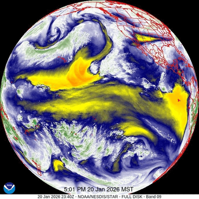 An eddy of low pressure has formed off the coast of southern California underneath a ridge of high pressure extending southward from Alaska. The formation of the eddy and its ingestion of tropical and subtropical moisture, representative of an atmospheric river, is clear in the accompanying thirty-two-hour time-lapse of water vapor satellite images between Tuesday and Thursday afternoons. Additionally, waves of energy moving over the ridge of high pressure and down its eastern side have mixed with arctic air from a persistent and deep vortex of cold air centered near Hudson Bay.
After a pleasant day today with some high clouds from the west and northwest and high temperatures in the mid-thirties, above our average of thirty degrees, the weather changes later on Friday.
Some energy moving down the ridge will force the eddy eastward, while some mixes with frigid air from central and northern Canada. This arctic air moving southward across the Northern Rockies on Friday will encounter the much warmer and wetter air moving northward around the eddy, creating a slow-moving frontal system that promises some snowfall and frigid air for all of Colorado this weekend.
Colorado will not be the only state affected, as the path of the one-time eddy will create a large band of winter weather lasting through the weekend, including likely devastating amounts of freezing rain from Texas to the Central Atlantic coast and heavy snow to the north.
Snowfall forecasts for our area are still changing, as the cold air trends further westward, with snowfall expected to start late in the day on Friday and continue into Saturday morning. We could see 3-6” of snow at mid-mountain by the Saturday morning ski report and up to a couple of inches in town, with some minor accumulations through noon before some drier air briefly passes over in the afternoon.
High temperatures will be quite cold, only reaching the low twenties in town and mid-single digits near the top of the Steamboat Ski Resort. A reinforcing wave of cold air and some moisture is now forecast to follow for the second half of the weekend, bringing some snowfall and even colder temperatures, with highs mired in the teens on Sunday in town and likely subzero up top.
Keep an eye on the Steamboat Powdercam and Mid-mountain Powdercam during the second half of the storm, as Steamboat can often do well in the cold back-end of a storm. While moisture will be limited in the very cold air, snow ratios can be absurdly high, though my feeling today is it will be too cold for anything but light snow.
The storm will be past on Monday, but temperatures will be slow to recover, especially if skies clear and Monday morning sees the predicted subzero temperatures, below our average of five degrees. Quiet weather follows for most of the workweek as a ridge of high pressure moves overhead, with unsettled weather possible around next Friday. Enjoy the wintry weekend, and check back for my next regularly scheduled weather narrative on Sunday afternoon.
Pleasant workweek to follow another mostly dry grazing cold front tonight
Sunday, January 18, 2026
Brilliant blue skies and temperatures in the upper teens at all elevations are over Steamboat Springs this Sunday at noon. Similar to Friday and Saturday, another mostly dry but warmer cold front will graze our area tonight, bringing clouds and some snow showers, with little accumulation expected. Afternoon sun and cooler temperatures will follow on Martin Luther King Jr. Day, ahead of a mostly sunny workweek with slightly warmer temperatures. The next chance for precipitation may appear at the end of the workweek, with uncertainty high for the weekend.
A ridge of high pressure persists over the West Coast along with its counterpart, a deep and cold trough of low pressure extending from the North Pole south through the Great Lakes toward the Gulf Coast. Pacific waves of energy have been traveling over the ridge, ingesting frigid and dry Arctic air, and moving down its eastern side.
A couple of these grazed our area on Friday and Saturday, with another one bringing clouds and some light snow showers tonight into Monday morning, with meager accumulations expected. Despite the afternoon sun, high temperatures in town should decrease by around five degrees from the mid-thirties today to around thirty degrees on Martin Luther King Jr. Day, right around our now-slowly-increasing average of twenty-nine degrees.
Pleasant workweek weather will be uneventful, with mostly clear skies and high temperatures rising to the upper thirties, and low temperatures falling to the single digits, around our average of five degrees.
The West Coast ridge of high pressure has kept significant snowfall away from our area for a week now, and that won’t change until the end of the workweek as several Pacific storms work their way under, through, and over the ridge. The evolution and track of these storms, and their interaction with the ridge, lead to an uncertain forecast starting at the end of the workweek.
Weather forecast models have settled on the leading Pacific storm weakening and splitting as it plows into the ridge, with the southern end forming an eddy early in the workweek, well off the coast of California. At least some of the northern branch will travel through the ridge, reaching our area around Friday and bringing a chance of snow, though amounts don’t look impressive at this time.
Uncertainty then follows for the weekend and the following workweek as the eddy moves eastward, as its speed and trajectory keep changing in the model forecasts. Furthermore, it is unclear if the ridge is vanquished or rebounds, further complicating additional interactions between the eastward-moving eddy to the southwest, possible Pacific energy from the west, and any cold air from the north.
Enjoy the pleasant workweek, and I’m sure to have more details on the coming pattern change in my next regularly scheduled weather narrative on Thursday afternoon.
A couple of dry and grazing cold fronts to start the weekend
Thursday, January 15, 2026
Temperatures are in the twenties at all elevations with bluebird skies this Thursday at noon in Steamboat Springs. A couple of grazing cold fronts will bring seemingly cold, but seasonable temperatures on Friday and Saturday, with a chance for some snow showers that may leave meager accumulations. Temperatures rebound on Sunday, with chances of significant snowfall a week away.
A broad ridge of persistent high pressure over the West Coast and a deep trough of low pressure over the eastern two-thirds of North America are dominating our weather. Waves of Pacific energy have traveled over the ridge of high pressure, ingesting frigid air entrenched over northern Canada. These waves then move down the east side of the ridge, grazing our area with cold but dry air.
For some reason, weather forecast models often underestimate the westward extent of these grazing waves, leading to colder and sometimes snowier outcomes. However, snowier is relative, and what was once a dry forecast for tonight and Friday night now has some possible snow showers, though any accumulations would be meager at best.
The first grazing cold front is scheduled for early Friday morning, lowering high temperatures in town from around forty degrees today to the mid-twenties on a cloudy and breezy Friday, finally below our average of twenty-nine degrees. High temperatures at the top of the Steamboat Ski Resort will struggle to reach the low teens.
There may be some snow showers, with meager accumulations possible at the higher elevations. The second grazing wave for early Saturday morning may also produce some snow showers, with temperatures similar to Friday, but with some afternoon sun.
Sunday should be a nice and sunny day with temperatures rebounding into the upper thirties. Another grazing wave is advertised for Martin Luther King Jr. Day, though its westward extent is uncertain.
Most of the following workweek looks nice, as our next chance for snowfall won’t be until Pacific energy travels through rather than over the eastern Pacific ridge of high pressure. Weather forecast models are struggling with the details of exactly how and when that will happen, though they agree that at least a weak system will affect us near the end of the workweek.
Enjoy the holiday weekend, and I’ll have more details on when we can expect our next snowfall in my next regularly scheduled weather narrative on Sunday afternoon.


