
Warm and dry workweek to precede a grazing cool front on Friday
Sunday, January 11, 2026
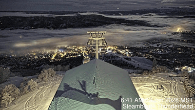
Sunshine filtered through high clouds, and temperatures in the upper teens at all elevations are over Steamboat Springs this Sunday at noon, after twenty inches of snow fell at mid-mountain and twenty-eight inches at the top of the Steamboat Ski Resort between Wednesday night and Friday at noon. Daytime temperatures through Thursday will warm to around forty degrees in town and the upper twenties at higher elevations before dropping by around ten degrees on Friday as a grazing cool front brings a brief chance of light snowfall.
 Before getting to the quiet workweek forecast, I’d like to spend a little time dissecting the Steamboat Magic that occurred in the thirty-four hours between 2 am on Thursday and noon on Friday, when twenty-eight inches of snowfall were recorded at the top of Sunshine Peak at 10,384′.
 Shown are the Steamboat Powdercam and the infrared satellite throughout the duration of the storm at two-hour intervals, as well as the temperature and twelve-meter wind at Storm Peak Lab at the top of the Morningside Lift. The ‘+’ marker on the satellite indicates the location of Steamboat.
Note that it snowed almost continuously except between noon and 6 pm on Thursday when some dry air aloft moved overhead, as indicated by the satellite. I’ve briefly paused the animation at noon on Thursday to highlight this dry area on the satellite.
The storm consisted of two parts: the first, before the arctic front, at around 3 pm on Thursday, and the second, post-frontal. Note the cloud movement on the satellite, indicating upper-level winds from the southwest, which carried moisture over the first cool, and then cold surface air in bands.
Also note the subtle switch to our favorable mountain-top northwest direction at 6 pm on Thursday, coincident with the resumption of snowfall. The cold temperatures, falling to zero by Friday morning, allowed for efficient production of dendrites, the familiar branched snowflakes which create fluffy powder, as moisture from the warm air aloft fell into the cold air below. Note the gusty and erratic winds on Friday morning as downdrafts from showers disturbed the mountain-top winds.
Finally, that last burst of one inch per hour snowfall between 10 am and noon on Friday was the result of convection forming in the cold and unstable northwest flow behind the storm, as seen by the bubbly clouds on the satellite.
We are now left with a stretch of calm weather as a ridge of high pressure builds over the West. We may warm into the mid-thirties today, above our average of twenty-nine degrees, and reach around forty degrees through Thursday. A couple of grazing waves moving down the east side of the ridge will affect our weather this workweek, with the first weak one bringing just clouds on Tuesday night. But the second one is stronger and will move further west, bringing clouds and possible snow showers on Friday, along with dropping high temperatures around ten degrees, closer to average.
So enjoy a pleasant workweek, and I’ll have more details on the Friday wave and whether the cool air lingers to start the weekend in my next regularly scheduled weather narrative on Thursday afternoon.
Arctic front to bring more snow tonight and cold temperatures to start the weekend
Thursday, January 8, 2026
After nine inches of snow fell from the first part of a storm at mid-mountain as of this Thursday mid-afternoon in Steamboat Springs, skies are overcast with a temperature of twenty-eight degrees in town and fourteen degrees at the top of the Steamboat Ski Resort. An arctic front associated with the second part of the storm moves through our area tonight, bringing colder temperatures for Friday and some snow tonight. After a cold start to Saturday, temperatures start to warm, reaching the mid-thirties on a mostly sunny Sunday.
A broad and cold trough of low pressure extends from Canada to the Mexican border, spanning the Canadian Rockies and Intermountain West, as well as the Great Plains. The first part of the storm was quite productive, with snowfall starting around 3 am and accumulating three inches by the Thursday morning ski report at 5 am, highlighted by an inch of snow between 3:40 am and 4:00 am. An additional six inches fell by 10 am, highlighted by two inches between 6:40 am and 7:20 am.
The second part of the storm will bring an arctic front through the area this evening as the main forcing stays to our west and then south. We could see an additional 1-4” of fluffy snowfall overnight, with snow showers continuing through about noon on Friday before some afternoon sun. High temperatures on Friday will only be in the teens in town, below the twenty-nine-degree average, and single digits up top.
Clouds on Friday night will prevent temperatures from plummeting as they insulate the surface like a blanket, but they may still reach below zero in town, below the four-degree average, as well as on the hill.
Temperatures will grudgingly warm to several degrees below average in town on Saturday, helped by some afternoon sun, as a ridge of high pressure begins to move over the West behind the departing storm. We could see mid-thirties on a mostly sunny Sunday, though the fresh snow cover and low sun angle may mean we warm more slowly than predicted.
The nice weather is forecast to continue into the next workweek, with a grazing storm forecast around midweek and another at the end of the workweek. Enjoy the wintry weather for the weekend, and I’ll have more details on the approaching storms in my next regularly scheduled weather narrative on Sunday afternoon.
Workweek to start with a warm storm and end with a cold storm
Sunday, January 4, 2026
A cloudy morning in Steamboat Springs this Sunday has given way to some noontime sun, with thirty-eight-degree temperatures in town and twenty-seven-degree temperatures at the top of the Steamboat Ski Resort. Similar to the warm storm that ended last Friday, which left seven-and-a-half inches of snowfall at mid-mountain, another warm storm is forecast to begin snowfall on Monday and last into Tuesday. After a short break, a colder storm is expected to start later Wednesday and linger into Friday.
 A blanket of fog covered the Yampa Valley Saturday morning after about six-tenths of an inch of liquid fell during the day Thursday and Thursday night. Even though dry air overspread the valley by Saturday morning, fog formed and persisted early in the day, as shown by the time-lapse from the Steamboat Thunderhead cam between 6:40 am and 10:40 am.
A trough of low pressure off the West Coast is now directing moisture over a ridge of high pressure over the Rockies, leading to our mix of sun and clouds. A wave of energy rounding the base of the trough will move overhead on Monday, starting precipitation as early as Monday morning. The storm will be warm, a few degrees cooler than the last storm, but that may be enough to limit the raindrops in town to perhaps a few hours around noon.
Gusty westerly winds reaching as high as 50 mph on Monday afternoon will accompany the snowfall, with snowfall briefly picking up around sunset as a cool front associated with the wave moves through. Mountain-top temperatures will slowly fall into the teens by Tuesday morning, though the best moisture may be past when the coldest temperatures arrive. We could see 3-6” at mid-mountain by the Tuesday morning report, with weather forecast models disagreeing on the amount of moisture behind the cool front and whether snow showers continue into Tuesday morning, with another inch or two of fluffier snowfall possible.
Meanwhile, incoming northern Pacific energy will force the West Coast trough to shear, with the southern end forming an eddy and perhaps affecting our next storm, and the northern end moving across the northern Rockies. The northern wave may drag another weak but dry cool front through our area on Tuesday afternoon, for another afternoon of gusty winds.
More incoming Pacific energy will carry a wave of energy and moisture, now over northern Japan, across the Aleutian Islands on Monday and the Gulf of Alaska on Tuesday. Cold arctic air from the north will be ingested into and strengthen the wave, bringing a storm across the Pacific Northwest on Wednesday.
Weather forecast models have struggled with the speed and strength of this wave and its eventual interaction with the remnants of the West Coast eddy. Right now, flurries could start Wednesday afternoon or evening, with stronger showers following when a leading cool front grazes our area on Thursday morning, and again when the much stronger arctic front follows on Thursday night.
While colder air by Friday morning is the more certain outcome, moisture availability is uncertain as it will depend upon the interaction between the cold storm from the northwest and the moist eddy to the south. It is also unclear whether the storm slows or even stalls, perhaps prolonging snowfall into Friday morning. We could see as much as 6-12”, or less than half that, depending upon the storm’s evolution.
Let’s hope these two storms can produce since warm and dry weather is forecast for the weekend, lasting into and perhaps through the following workweek. I’ll have more details on the colder storm to end this workweek in my next regularly scheduled weather narrative on Thursday afternoon.
Nice start to the weekend after a warm Friday storm
Thursday, January 1, 2026
Cloudy skies are over Steamboat Springs this noon on New Year’s Day, with temperatures around thirty degrees in town and twenty-seven degrees at the top of the Steamboat Ski Resort. An approaching warm storm will bring significant snowfall above 8,000′ tonight and Friday ahead of nice weather to start the first weekend of 2026. Another warm storm is forecast to begin on Monday.
The remnants of a weakening eddy now over central California, part of which was left behind from the storm last weekend, has ingested tropical and subtropical moisture while it was vacationing off the West Coast earlier this week. The eddy is forecast to move through the ridge of high pressure over the Rockies that brought the gorgeous weather to the Yampa Valley this past week.
Snow showers will start this afternoon at the higher elevations, but snow levels around 7,500′ mean showers will be either liquid or a wintry mix at the lower elevations when precipitation eventually starts later this afternoon.
The eddy remnants are forecast to move through Nevada and Utah tonight, and Colorado on Friday. Very little cold air is associated with the storm, with temperatures dropping only a few degrees around noon on Friday, as a weak cool front passes with the storm.
But a lot of moisture, and first westerly and then northwesterly winds impinging on and lifted by the Park Range should create significant orographic, or terrain-lifted, snowfall above 8,000′. We could see 3-6” of snow at mid-mountain for the Friday morning report, with another 3-6” during the day. An additional 1-4” could fall through Friday evening in favorable, but drying, northwest flow behind the storm.
Meanwhile, a narrow trough of low pressure, extending southward from the Gulf of Alaska, will evolve in a complicated fashion through the weekend as waves of energy move eastward across the Pacific and southward from Alaska.
A transient ridge of high pressure forming over the West behind the departing storm and ahead of the eastern Pacific trough will bring warming temperatures and mostly sunny skies on Saturday. Weather forecast models agree that energy and moisture slingshot around the base of the trough will bring precipitation chances back to our area to start the workweek; however, it is uncertain whether mostly sunny skies will persist into Sunday for part or all of the day.
Enjoy what should be the first powder day of 2026 on Friday and a nice start to the weekend, and I’ll have more details on the Monday storm in my next regularly scheduled weather narrative on Sunday afternoon.
Temperatures to warm through the rest of this year ahead of precipitation chances for the New Year
Sunday, December 28, 2025
A brisk winter day with mostly sunny afternoon skies is over Steamboat Springs this Sunday, with temperatures in the low twenties in town and only two degrees at the top of the Steamboat Ski Resort at mid-afternoon. After a foot of fresh powder fell at mid-mountain and fifteen inches up top, warming temperatures and mostly sunny skies will close out 2025, with precipitation chances returning for the start of the New Year.
A ridge of high pressure is building over the West behind the departing storm and ahead of an elongating trough of low pressure extending southwestward from Alaska to the south of the Aleutian Islands. Clear skies tonight, light winds, and fresh snow will create ideal conditions for subzero temperatures in town, below our average of four degrees.
Dry air under the ridge will make for a beautiful three days to close out 2025, with temperatures warming into the upper-twenties on Monday. Weather forecast models often overestimate the amount of warming after snowy intrusions of arctic air, as the low sun angle and highly reflective snow surface minimize daytime heating. But if the models are to be believed, we could see upper thirties on Tuesday and back to the low forties by Wednesday, well above our average of twenty-eight degrees, with continued mostly sunny daytime skies.
Meanwhile, waves of cold air moving southwestward from Alaska and eastward from Siberia will shift the Aleutian trough eastward into the Gulf of Alaska, forcing further elongation to the south. Additionally, the southern part of the current storm, left behind to our southwest, will merge with a wave moving southwestward over Nevada and form an eddy off the coast of southern California by Monday, ingesting subtropical moisture as it vacations there for a few days.
Eventually, the moist and warm eddy will be forced eastward by the original Aleutian trough now over the eastern Pacific, though how the trough evolves and how it interacts with the eddy are uncertain. Most weather forecast models force the weakening eddy across the Desert Southwest around midweek, bringing increasing clouds on New Year’s Day and precipitation chances by the evening.
Snow levels will rise with the warm temperatures, eventually reaching about 7,500′ by Thursday afternoon, so any precipitation will probably be liquid in town and modest on the hill. What happens behind that will depend upon the evolution of the eastern Pacific trough, with some models bringing a portion of that trough over our area later in the weekend. If that occurs, pleasant weather is expected for most of the first weekend of 2026, followed by unsettled weather to start the next workweek.
Enjoy the results of the game-changing weekend storm at the Steamboat Ski Resort this week, and I’ll have more details on expected snowfall amounts by Friday and the weekend outlook in my next regularly scheduled weather narrative on Thursday afternoon.


