
From Green to Gold in 2 days at the Steamboat Ski Area
Friday, September 19, 2014
After a late start, the fall color show has seemingly appeared overnight! Well, not quite overnight, but literally in several days. Monday afternoon, the Twilight trees in the Priest Creek Area were tinged with light green, by Tuesday they were light yellowish and by Wednesday they were full yellow.
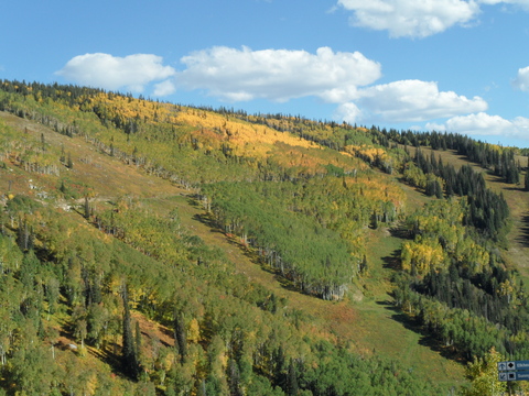 I escaped for a mid-afternon ride Thursday afternoon as temperatures touched 80F in the Yampa Valley. I took the this picture looking over Priest Creek from the Elkhead loop, and you can see the Duster road cutting horizontally across the middle of the picture.
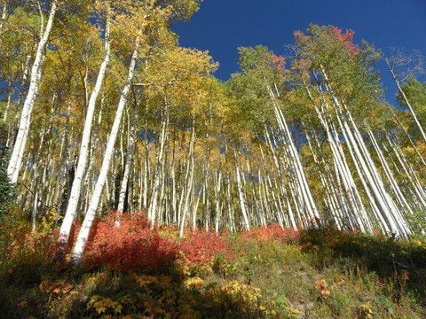 I like riding the Sunshine loop in a counter-clockwise direction, so the next picture is taken from the Duster road looking up at the Twilight trees. The underbrush has turned a beautiful red color which contrasts nicely with the aspen.
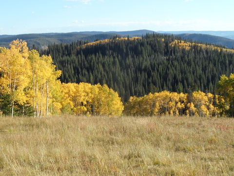 This picture was taken looking down what I believe is Flintlock about a third of the way up the new reroute of the Sunshine Trail
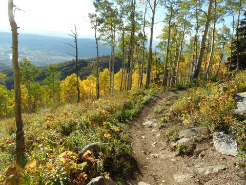 Finally, I took this picture cruising down the long traverse on Sunshine Trail somewhere in the Shadows area. You can see the town of Steamboat Springs over the ridge in the left hand side of the picture down in the valley floor.
Independence Day funnel clouds in Steamboat Springs
Saturday, July 5, 2014
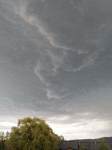
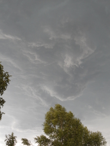
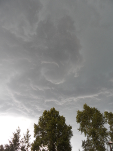
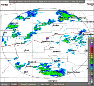
Fireworks in Steamboat Springs started ahead of schedule on late Friday afternoon as funnel clouds appeared over the the south part of town around 5:30 pm MDT. These photos were taken on Village Dr, first near Meadow Lane and then about 1/4 mile north near Walton Creek Rd. As the radar loop from Grand Junction in the lower right shows, the storm rapidly gained strength soon after 5:09 pm MDT and was quite strong between 5:28 and 5:48. During this time, rotation was evident in several areas of the cloud base, and it appeared that 2 or 3 shallow funnels briefly formed around this time. Along with favorable wind shear that helped cause the rotation, atmospheric instability was enhanced as the storm formed along a dry-line that was present at the boundary of the moist monsoonal air to our south and some drier air to our north and west that appeared in the afternoon.
Uphill access restored to Zig Zag between Thunderhead and Creekside
Wednesday, July 2, 2014
The Steamboat ski area recently completed the lower section of the mountain biking downhill trail Tenderfoot, and as promised 2 long years ago, restored uphill access on the old Zig Zag trail between the base of the Thunderhead lift and the top of Creekside. This is great news for uphill riders like myself as we will no longer be subjected to the mind-numbingly boring ride up Why Not road to gain access to the excellent Creekside singletrack.
Personally, this has restored my standard lunchtime ride which I call the Creekside-8, which traces out a figure eight by following Zig Zag from the gondola to the top of Creekside, then down Creekside and back up Burgess Creek Road to Lower Valley View and finally the top of Christy Peak, then down Lower Rustler’s Ridge to the base of the gondola. It’s about 1800 vertical feet with two excellent descents separated by a 15 or 20 minute climb up Lower Valley View.
The trails are riding great after the rain we received last Friday, and the trail crews are keeping the singletrack and widetrack in excellent condition.
Closing day storm delivers the goods
Monday, April 14, 2014
The storm forecast for closing day was indeed interesting! The Steamboat ski area reported 2” mid / 3” top at 5 am as some convection ahead of the cold front brought rain to the valleys and snow to the hill. Then we were affected by 3 pulses of energy, though the first or these was limited in impact as there was only 4” of snow at 1 pm up top. 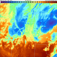 However, at this time, the second pulse delivered good snow and was quickly followed by a TROWAL (TRough Of Warm air ALoft), which is evident on the IR satellite loop shown on the right (first image at 10:11 am MDT and last image at 5:45 pm MDT on 13 April 2014). This is seen as convective plumes generated over the southern Front Range propagated northwestward over the Continental Divide and into our area. The powdercam at the top of Sunshine Peak showed 6” of snow fell between 1pm and 3pm, with 3.5” falling between 2 pm and 3 pm!
The intense snowfall rates also brought snow to the valleys with over 6” of snow falling in the 5 hours between 11:30 am and 4:30 pm. Additionally, temperatures at Storm Peak Lab near the top of Mt. Werner fell from about 23F around noon to 14F at 4pm, and kept falling through this morning until the temperature reached a mid-winter -1F!
Ski conditions moved from good to great to outstanding, and as advertised in earlier forecasts, the last run of the day was the best, with 10” of snow shown on the powdercam and over a foot measured in the favored areas. The mountain was also relatively sparsely populated due to the events at the base, though I’m sure the mid-winter storm skiing also discouraged those expecting spring conditions!
Some good skiing today followed by a week of unsettled weather
Monday, March 31, 2014
Though the powdercam at the top of Sunshine Peak read just under 4” at 5 am, the Steamboat ski area reported 6” mid / 7” up top for the morning report, and I measured 4” on my deck. I’m at a loss in explaining why the powdercam did not reflect the reported measurement since they are located in close proximity.
The snow on the upper mountain was wind affected, and the runs with a western aspect were inconsistent. However, areas protected from the wind skied creamy and bouncy, as the snow that fell last night was relatively dense.
Surprisingly, the best run I found on the front side of the hill was High Noon down to Rolex. High Noon had been recently groomed and there was a nice layer of fluff on top of a soft surface. And the snow had blown into the right side of Rolex, especially in the lower half of the run. There I found the 7” advertised on the report, and it was only lightly skied, probably due to the visibility being far less than optimal on the open runs. It was so good I did a five runs in a row before finally moving on!
Trees skied OK, but really any place you could find that was consistent skied great. And with that in mind, I was able to ski North St. Pats relatively early in my ski day, and was rewarded with an untracked line down the right side of the main pitch. Deep and steep bottomless turns were some of the best of the day, though there are only so many of them that can fit in the short pitch! I also found great deep snow on the Third Pitch out of Gate 3, though I would caution against venturing in that area without knowledge or guidance, especially since it involves some cliff bands and a 15 minute slog back to the ski area.
This storm will be quickly followed by a complex storm presently just off the coast of northern California that will turn our winds to the southwest by tonight. Several pieces of energy are forecast to be ejected over us in this relatively warm southwest flow even, as main low over California moves southward. Showers on Tuesday will likely remain as rain or a mix at lower elevations in the warming temperatures, though snow should occur above Thunderhead, and I would expect 1-4” to be reported by Wednesday morning.
This pattern persists for Wednesday, though showers will increase and snow levels fall a bit as the main storm moves eastward long the Utah - Arizona border. We will get some cooling on the back side of the storm by late Wednesday as it finally moves east of us, and I would expect around 3-6” by Thursday morning. Snows will likely continue Thursday morning before tapering off by the afternoon.
A transient ridge moves over Great Basin late Thursday / early Friday before another storm enters the west coast on Thursday. There is a fair bit of model uncertainty as to whether this system splits and to what degree, but it appears that this storm helps carve out a persistent trough over the Great Basin. This trough then keeps us in moist and cool northwest flow for a long-lasting snow event, possibly lasting through the weekend and into the next workweek.


