Storm train to start midweek
Sunday, November 15, 2026






Skies have cleared over Steamboat Springs late on this Sunday afternoon after 3” of snow fell at the top of the Steamboat Ski Resort and between one and two tenths of an inch of rain fell in town overnight. A couple of nice days will start the workweek before the first in a series of storms brings modest snowfall to all elevations by Wednesday. A short break on Thursday will herald the cavalry’s arrival on Friday, with a promising storm bringing significant snowfall just in time for Opening Day on Saturday.
Behind last night’s quick-moving storm, a transient ridge of high pressure will build over the West ahead of a series of storms developing in the Gulf of Alaska. After reaching 50 degrees today, above our 43-degree average, even warmer temperatures in the mid-to-upper 50s are forecast for Monday and Tuesday.
That will end our extended warm stretch this fall, as the first in a series of storms brings increasing clouds on Tuesday afternoon and a cold front Tuesday night. The storm will weaken as it moves across the Great Basin and pushes the ridge eastward, with snow levels falling to the Yampa Valley bottom overnight. We could see as much as an inch or two of snow in town by Wednesday afternoon, and 2-5” on the hill.
A much stronger, colder, and wetter storm now moving across the Aleutian Islands will mix with cold air moving south across the Bering Sea and Alaska, eventually forming an eddy and approaching the West Coast by midweek.
A very active jet stream across the Pacific will keep the eddy moving across the Great Basin, crossing California on Thursday and approaching our area on Friday. Early forecasts have the snow starting by midday Friday and continuing through the night, just in time for Steamboat’s scheduled Opening Day on Saturday. My preliminary estimate is 6-12” by Saturday morning, especially since we see the favorable cool, moist, and unstable northwest flow behind the late-Friday cold front. However, that ultimately depends on the storm’s track and evolution.
The good news looks to continue, with another small storm after the weekend, followed by a very active and favorable weather pattern that looks to start just before Thanksgiving.
But that is getting well ahead of a viable forecast. So enjoy the last 2 days of our mild fall, with more details on the Friday storm at the Bud Werner Memorial Library this Wednesday at 6:30 pm, where I hope to show off a refreshed website, talk a little about El Niño and what it means for the Yampa Valley, and show you how to make a weather forecast. And of course, answer your burning meteorology questions! If you can’t join me then, look for the latest update in my next regularly scheduled weather narrative on Thursday afternoon.
Friday update
Friday, November 13, 2026
A change in the weather pattern will bring unsettled conditions to Steamboat Springs beginning Saturday, with two storms, and possibly a third, delivering accumulating snow ahead of the ski area’s scheduled Opening Day next Saturday.
Saturday will start dry before the first storm crosses the Great Basin, bringing rain showers to lower elevations and snow showers to the mountains. Timing remains uncertain because of the storm’s splitting nature, with showers possible as early as late morning or holding off for much of the day. Several inches of snow could accumulate atop the Steamboat Ski Resort through Sunday morning, while Yampa Valley temperatures reach around 50 degrees.
The quick-moving system should depart by Sunday, allowing skies to clear and temperatures to stay around 50 degrees.
Meanwhile, a stronger, colder and wetter storm is developing south of the Aleutian Islands, having absorbed tropical moisture from the western Pacific. It is expected to intensify over the Gulf of Alaska early next week, mixing with cold air moving south from the Bering Sea and Alaska.
Ahead of its arrival, southwesterly winds will push temperatures into the mid-to-upper 50s Monday and Tuesday. Timing remains uncertain, but accumulating snow at all elevations is possible Wednesday as the storm passes. Another system could follow, bringing continued cool, wet weather with significant snowfall accumulations into Opening Day, the following Saturday.
Pattern change to bring unsettled weather starting Saturday
Thursday, November 12, 2026
A beautiful day is over Steamboat Springs this Thursday mid-afternoon, with temperatures in the upper 50s and nary a cloud in the sky. Similar weather on Friday will precede a pattern change, bringing cool, unsettled weather to our area on Saturday as the first of a couple of storms moves overhead. A second stronger, colder, and wetter storm is forecast around midweek, just in the nick of time for Steamboat’s scheduled Opening Day a week from Saturday.
The ridge of high pressure over the West responsible for this week’s gorgeous weather is spending its last couple of days overhead before being forced eastward by a storm approaching the West Coast. Some clouds Friday will do little to dent the high temperatures, with another day in the upper 50s, well above the 44-degree average.
While Saturday will begin dry, high-elevation snow showers and low-elevation rain showers will start later in the day as the storm crosses the Great Basin. Timing is uncertain due to the storm’s splitting nature, with showers starting as early as noon or holding off for most of the day. Several inches of snow are possible at the top of the Steamboat Ski Resort, with high temperatures in the Yampa Valley around 50 degrees. Keep an eye on the snowfall accumulations at the upper-mountain and mid-mountain Powdercams.
This is a quick-moving storm with skies clearing Sunday, and high temperatures in the low 50s.
Meanwhile, a promising storm south of the Aleutian Islands has ingested tropical moisture from the western Pacific, intensifying over the Gulf of Alaska early next week as it mixes with cold air moving south from the Bering Sea and Alaska.
Temperatures will rebound to the mid-to-upper 50s from Sunday through Tuesday as southwesterly winds ahead of the developing storm carry warm air overhead. Timing is uncertain, but we should see accumulating snow at all elevations by Wednesday as the storm passes, with cool, wet weather possibly continuing into Opening Day on Saturday as another storm follows.
Enjoy the nice weather and dry trails while they last, and I’ll have more details on the evolving midweek storm in my next regularly scheduled weather narrative on Sunday afternoon.
Another week of beautiful weather
Sunday, November 8, 2026
Sunny skies and temperatures in the upper 50s are over Steamboat Springs this Sunday mid-afternoon. Warm and dry weather will continue for the next week, briefly interrupted by a grazing cool front on Tuesday that will bring slightly cooler temperatures and afternoon breezes.
High pressure dominates most of the West, bringing warm temperatures more than 10 degrees above our 46-degree average. A series of storms rotating through persistent low pressure over the Gulf of Alaska will bring cool, unsettled weather to the Pacific Northwest this week. One of these storms is forecast to be strong enough to dent the ridge on Tuesday, ingest some cold air moving southward from northwest of Hudson Bay, and graze our area with a cool front Tuesday afternoon before intensifying over the Midwest and Northeast after midweek.
A mostly sunny Monday with high temperatures around 60 degrees will be followed by several degrees of cooling and afternoon breezes, on Tuesday with some clouds possible as the cool front grazes our area.
Meanwhile, a lobe of cold air moving southward through the Bering Sea will mix with northern Pacific energy, forming a deep storm extending southward from the Gulf of Alaska by midweek. Until recently, that storm was forecast to bring wintry weather to our area by the end of the workweek, but weather forecast models have recently trended toward a splitting storm as it approaches the West Coast on Thursday.
Between that storm and low pressure developing over the Midwest, the western ridge of high pressure will strengthen through the workweek, keeping warm temperatures in the upper 50s and clear skies overhead.
The pattern may change around or soon after next weekend, but that suggestion has often appeared at the end of recent long-range forecasts.
So enjoy the beautiful workweek weather, hope for cold enough upper-mountain nighttime temperatures for at least several hours of snowmaking each night, and I’ll have more details on the possible pattern change in my next regularly scheduled weather narrative on Thursday afternoon.
Sunny skies and warming temperatures for the weekend
Thursday, November 5, 2026
Temperatures are around 40 degrees at this dark, 6 pm hour this Thursday in Steamboat Springs. A storm splitting to our west will bring some clouds on Friday, with mostly sunny skies and warming temperatures for the weekend. There is little hope for precipitation for at least the next week.
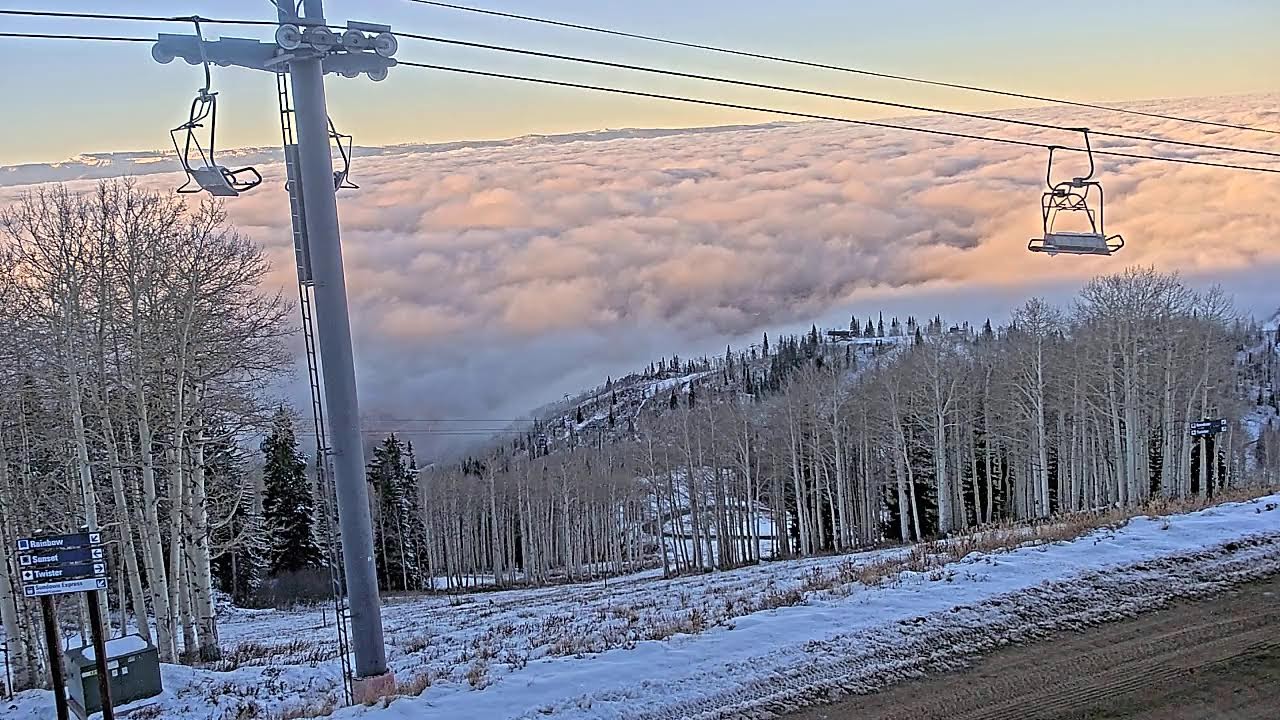 A stunning sunlit blanket of fog, captured in the included picture by the Four Points cam, covered the Yampa Valley early this morning. This may be the weather highlight for a while.
A weak storm is splitting over the Great Basin, with the southern part forecast to form an eddy over the Desert Southwest before moving into Mexico by Saturday, and the weaker northern part moving across the Northern Rockies. Our area will see only clouds tonight through Friday morning, with skies clearing in the afternoon and high temperatures just above our 48-degree average.
As a series of storms rotate through a strong area of low pressure over the Gulf of Alaska this weekend and beyond, a ridge of high pressure will move overhead. Sunny skies are forecast for this weekend, with high temperatures in the low 50s on Saturday and upper 50s on Sunday.
Similar weather will continue through most of the workweek before there may be some hope that Gulf of Alaska energy and moisture move into the West. So enjoy a very nice weekend, and I’ll have more details on how long this pleasant weather may last in my next regularly scheduled weather narrative on Sunday afternoon.