Nice workweek to follow a last round of showers today
Sunday, October 25, 2026






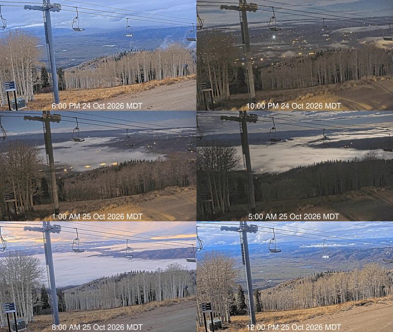
After a night of moonlit fog in Steamboat Springs, captured below as a time-lapse from 6 pm Saturday to noon today, a couple of hours of late-morning sun is yielding to cloudy skies ahead of another round of afternoon and evening showers. But the sun returns by Monday afternoon, with warming temperatures and mostly clear skies persisting for most of the workweek. A more substantial storm is forecast for around next weekend, or shortly after.
 An eddy left over from the previous storm is moving toward Colorado from Arizona. Increasing clouds will precede the start of showers later this afternoon as energy from the approaching eddy rotates northward around the frontside of the eddy.
Snow levels are now just above mountaintop, and fall to around 8,500′ by Monday morning, so showers starting later this afternoon may lead to minor snowfall accumulations at higher elevations as the eddy moves overhead.
Skies should be clearing Monday morning, with mostly sunny skies by the afternoon and high temperatures in the low 50s, just below our 54-degree average.
Meanwhile, the northern part of a storm that split in the Gulf of Alaska on Friday is over Vancouver, while the southern part has formed an eddy which will weaken and loiter over the east-central Pacific this week. While most of the Vancouver part of the storm is forecast to be pushed eastward on Monday by a quick-moving pulse of cold air from Siberia, the central Pacific eddy may be a player in our next storm as the Siberian wave settles over Vancouver by midweek before elongating southward along the West Coast by the end of the workweek.
By Tuesday, the Vancouver eddy will have crossed Idaho and moved into Montana, staying north of our area and bringing a breezy Tuesday afternoon. A ridge of high pressure begins building over the Great Plains behind the storm, keeping mostly sunny skies overhead and allowing high temperatures to rise from the mid-50s on Tuesday toward 60 degrees on Wednesday, staying above average for the rest of the workweek.
While the workweek will be nice, it’s too early to speculate on Halloween’s weather, as that will depend upon the developing late-week storm along the West Coast and how it interacts with the decaying central Pacific eddy. I’ll have more details about that in my next regularly scheduled weather narrative on Thursday afternoon.
Friday afternoon to see a break in the showery weather lasting into Saturday
Thursday, October 22, 2026
A gray day is over Steamboat Springs this Thursday mid-afternoon, with temperatures in the upper 50s and light rain showers. A storm to our west, in cahoots with the remnants of Hurricane Trudy, will split tomorrow, bringing a break in the showery weather lasting from Friday until at least Saturday afternoon. The southern part of the split may bring more showery weather later on Saturday and again Sunday before a nice start to the workweek.
The California eddy discussed in my last weather narrative is moving into Nevada after directing the tropical moisture from former Hurricane Trudy over the Intermountain West. A wave traveling across the Pacific Northwest will split, with the northern part forcing some of the eddy northeastward toward Idaho and Montana on Friday and the southern part helping to reform the eddy over Arizona by Saturday.
After continuing showers through tonight, drier air between these features should bring mostly sunny skies from Friday afternoon through Saturday morning. Uncertainty remains about how quickly the Arizona eddy moves northeastward, which affects our afternoon and evening shower chances through the weekend, as monsoonal moisture from the south is directed northward by the southerly winds ahead of the eddy.
Increasing clouds Saturday afternoon may bring slight shower chances after high temperatures reach around 60 degrees on Friday and low 60s on Saturday, above our 55-degree average. Good shower chances appear by Sunday afternoon or evening as the Arizona eddy approaches, with clouds keeping the high temperature in the upper 50s.
It should be cold enough for an inch or two of snow at mountaintop by Monday morning. If the eddy moves as fast as forecast, sunny skies should return by Monday afternoon, with high temperatures falling to the low-to-mid-50s behind the storm. The nice weather should last through Tuesday, before longer-range weather forecast models disagree on the speed and southern extent of another storm moving through the Gulf of Alaska and possibly grazing our area around midweek.
So enjoy the sunny periods on Friday and Saturday, and I’ll have more details on the possible midweek storm in my next regularly scheduled weather narrative on Sunday afternoon.
Nice start to the workweek followed by increasing shower chances
Sunday, October 18, 2026
Temperatures are just below 65 degrees with mostly sunny skies in Steamboat Springs this Sunday mid-afternoon. After a nice start to the workweek, shower chances increase from the moisture associated with yet another decaying hurricane, our third so far this year, and depend upon the evolution of a Gulf of Alaska trough and its interaction with the hurricane. Next weekend’s weather outlook will depend on how these features interact, and the eventual effects of another storm moving through the Gulf of Alaska.
A storm off the Vancouver coast is splitting, with the southern part of the storm forecast to form an eddy off the California coast by Tuesday. Additionally, a weak area of low pressure lies over the southern California border, and Hurricane Trudy is south of the Baja Peninsula.
As the Vancouver storm elongates southward, southwest winds ahead of the storm will carry the Southern California low northeastward, bringing some clouds and a small chance of a shower late Monday afternoon. High temperatures will once again rise to the low-to-mid 60s, above our 58-degree average.
Similar weather is forecast for Tuesday, before moisture from the northward-moving Hurricane Trudy is ingested into the southwest winds ahead of the developing California eddy.
Meanwhile, a ridge of high pressure over Texas starts building by midweek, just as the California eddy begins moving eastward. While the forecast initially called for likely rain around or soon after midweek for a day or two, the Texas ridge may complicate the eddy’s movement and its interaction with the remnants of Trudy, perhaps slowing or splitting the eddy.
The ridge will be close enough for another several degrees of warming on Wednesday, with shower chances later in the day dependent upon the proximity of the eddy. Similar uncertainty extends into Thursday, with another Gulf of Alaska storm crossing the Vancouver coast and adding additional forecast uncertainty for the end of the workweek and the weekend.
Until then, the local trails have dried out nicely behind last week’s storm, so enjoy the pleasant weather to start the workweek, and I’ll have more details on the evolving storms in my next regularly scheduled weather narrative on Thursday afternoon.
Beautiful and seasonable weekend ahead
Thursday, October 15, 2026
Temperatures have reached 50 degrees under mostly sunny skies late this Thursday afternoon in Steamboat Springs after several wet, stormy days, including significant high-elevation snowfall overnight. After a chilly Friday morning with low temperatures in the teens, the season’s coldest so far, mostly clear skies and temperatures warming into the seasonable low-60s are forecast for a beautiful weekend.
 The wet weather came from the remnants of former Hurricane Rachel, steered overhead by a cold Northern Pacific storm, which eventually brought our upper-elevation snowfall. Mid-mountain received 5” of snow from late Wednesday afternoon through this morning, with 8” recorded at the top.
Snow levels fell to 8,000′, with even some snowflakes in town late yesterday afternoon and again early this morning.
Precipitation since last Saturday was impressive, with about 0.4” during that day, 0.3” on both Monday and Tuesday, and as much as an inch yesterday, bringing about 2” of beneficial moisture, just shy of the 2.2” monthly average.
But we are drying out through the weekend and into next week as a ridge of high pressure builds and moves over the West behind the departing storm and ahead of a cold storm developing in the Gulf of Alaska. And with clearing skies behind a cold storm, expect temperatures to plummet tonight to the coldest of the season so far, reaching the teens, well below the 26-degree average.
High temperatures will warm to around our average of 59 degrees on Friday despite the cold start, and reach the low 60s for a beautiful weekend under mostly sunny skies. Low temperatures will also rise into the mid-to-upper 20s on Saturday morning and the low 30s on Sunday morning.
The beautiful weather will extend into the next workweek as the intensifying Gulf of Alaska storm is deflected to our north by the western ridge of high pressure. However, the remnants of former Typhoon Koguma, now south of the Aleutian Islands and expected to ingest cold air traveling south across Alaska, are forecast to form another elongated trough of low pressure off the West Coast by Tuesday, similar to this past storm.
Longer-range weather forecast models have the southern part of the storm forming an eddy around California, traversing the Great Basin through midweek, and possibly affecting our area just after midweek. So enjoy the gorgeous weekend ahead, and I’ll have more details about the incoming storm in my next regularly scheduled weather narrative on Sunday afternoon.
Storm to bring the first snow to the Steamboat Ski Resort by midweek
Sunday, October 11, 2026
Steamboat Springs is drying out this Sunday at noon after receiving as much as a half inch of rain on Saturday ahead of an approaching storm. Showers later today and Columbus Day will pick up on Tuesday as a Pacific Northwest storm approaches, bringing the season’s first snowfall to the Steamboat Ski Resort starting Tuesday night. Cold temperatures in town with highs in the 50s and lows below freezing will accompany the storm’s cold front, with precipitation on Wednesday clearing by Thursday. Warming temperatures and mostly sunny skies will end the workweek and persist through the weekend and into the following workweek.
A cold, elongated trough of low pressure extending southwestward from the Pacific Northwest has captured the remnants of Tropical Storm Rachel, with eastern Nevada and western Utah forecast to receive the best precipitation through tonight.
Southwest winds ahead of the storm carried some moisture from Rachel overhead on Saturday, with some temporary drying through mid-afternoon today before showers pick up again tonight. High temperatures will be about 70 degrees today, above the 61-degree average, with gusty southerly winds. Columbus Day will see possible showers throughout the day, with highs in the low-to-mid 60s, as the trough of low pressure evolves into an eddy and travels through the Great Basin beginning Monday night.
Shower chances increase on Tuesday and become likely by Tuesday night as the Great Basin eddy reaches the western Colorado border, bringing a cold front through our area. Snow levels will fall from about 10,000′ to 9000′ from Tuesday night through Wednesday, when we should see the bulk of the precipitation. Snow above as low as 8,500′ and rain below will transition to showers and continue into Thursday morning in the favorable cool, moist, unstable northwest flow behind the storm, with 3-6” of snow possible above mid-mountain. Be sure to keep an eye on the Steamboat Powdercam during the storm as the season’s first snowfall accumulates!
High temperatures in town may struggle to reach 50 degrees on a raw, rainy Wednesday, with highs in the mid-50s on a clearing Thursday, and lows in town falling below freezing for the first time this season. Even colder lows in the mid-20s are likely Friday morning as the clear skies behind the storm allow for efficient nighttime cooling.
Temperatures warm into the 60s under mostly sunny skies to end the workweek as a ridge of high pressure moves over the West ahead of a developing storm in the Gulf of Alaska. So enjoy the nice afternoon today, brace for the midweek storm, and look forward to a picturesque, snow-capped Mt. Werner on Thursday. I’ll have more details on the likely pleasant weekend in my next regularly scheduled weather narrative on Thursday afternoon.