Good shower chances starting midweek
Sunday, September 10, 2023
After a few raindrops fell mid morning in Steamboat Springs, skies are a mix of sun and clouds with temperatures in the low seventies early this Sunday afternoon. After some sun this afternoon, modest chances for light showers return for this evening and overnight ahead of a dry Monday. Shower chances begin increasing by later Tuesday with good chances of wetting rains starting Wednesday and lasting into Friday.
Currently, one broad area of low pressure extends from the Gulf of Alaska westward across the Bering Sea while another area extends southward from Hudson Bay southward across the Great Lakes. Additionally, former eastern Pacific hurricane Jova has weakened into a tropical storm and is located well of the coast of Baja.
Weak winds generally from the west are currently traversing the central Rockies, and have brought some moisture from Jova overhead. The moisture is forecast to hang around through tonight, bringing modest chances of light showers for later this afternoon and overnight. The winds from the west will also keep a more seasonable air mass overhead than this past week, with high temperatures today near our average of 75 F and falling a degree or two on a likely dry Monday.
But a wave of energy and moisture traveling through the low pressure area across the Gulf of Alaska from the Bering Sea is forecast to make landfall over the Pacific Northwest coast Tuesday night and move through our area later Thursday.
So look for some shower chances to possibly return as soon as later Tuesday as energy ahead of the main wave moves overhead, perhaps enhanced by mixing with some moisture that is left from Jova. There is weather forecast model disagreement on whether this moisture makes it far enough north for shower chances, though in any case high temperatures look to again reach the low seventies after a sunny start to the day.
Good chances for wetting rains start Wednesday afternoon and last into Friday afternoon, with the heaviest showers forecast for Thursday as the main wave moves overhead. High temperatures will fall into the upper sixties for all three days, and there may even be some snowflakes in the air at the top of the Steamboat Ski Resort Friday morning as low temperatures there fall into the thirties.
Weather forecast models have a ridge of high pressure building over the West behind the departing wave bringing dry weather and eventual warming temperatures through next weekend. Enjoy the dose of changeable fall-like weather this work week, and be sure to check back for my next regulalry scheduled weather narrative on Thursday afternoon for more details on the weekend weather.
Showers chances return for Sunday
Thursday, September 7, 2023
Temperatures are in the mid-seventies with nary a cloud in the sky early this Thursday afternoon in Steamboat Springs. After another couple of days of similarly gorgeous weather, shower chances return on Sunday as a weak cool front grazes our area.
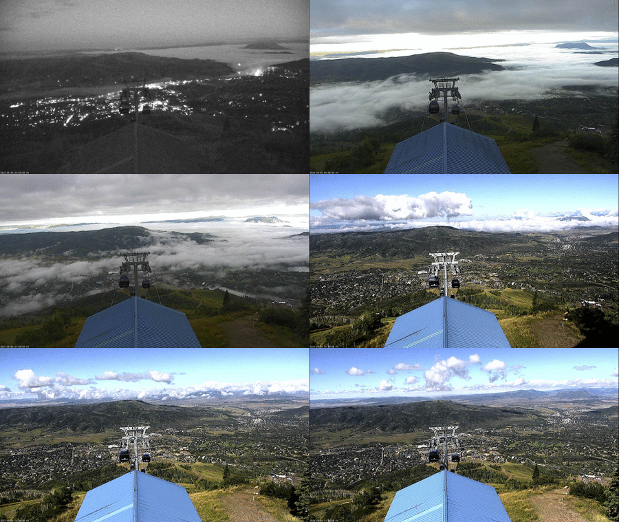
 This past weekend saw our first storm from the northwest this season along with a cold front that blasted through our area Monday morning around 10 am followed by a day of showers starting at noon. I’ve included a time lapse of the view from Thunderhead between 6:20 am and 11:40 am Tuesday morning that shows the low clouds and fog encroaching on the town of Steamboat Springs as cool air rushed down the Elk River drainage before receding and lifting and eventually turning into some shallow fair weather cumulus clouds as the sun heated the valley floor.
Currently, a fairly flat ridge of high pressure is centered over the Rockies while a weak storm is located off the Pacific Northwest coast and a strong storm is located over Alaska. The Pacific northwest storm is forecast to move across Montana on Friday and mix with some cool air from the northern latitudes on Saturday. Additionally, some Pacific energy and moisture is forecast to pass south of the Alaska storm today and eventually move over our area on Sunday while mixing with some of that cool air to our northeast.
Before any of that cool air makes it to our area as early as noon on Sunday, look for another couple of gorgeous days of weather Friday and Saturday similar to today, but a bit warmer with high temperatures around eighty degrees, about five degrees above our average of 76 F.
But shower chances will appear on Sunday as the weak cool from grazes our area, perhaps as early as noon and lasting into the evening. However, these showers and the cool front will be nothing like what occurred last Monday, with showers being far lighter and more scattered and high temperatures falling to the low seventies.
These cooler temperatures look to stick around into the next work week along with a mix of sun and clouds as weak waves of Pacific energy and moisture continue to move overhead from the northwest. Weather forecast models disagree on what follows for the rest of the work week with the European ECMWF reintroducing some showery weather around midweek while the American GFS keeps us dry.
So enjoy the spectacular start to the weekend, and be sure to check back to my next regularly scheduled weather narrative on Sunday afternoon to see what weather we may see next week.
Showery weather to continue ahead and along the Labor Day cold front
Sunday, September 3, 2023
The sun is back out again over Steamboat Springs early this Sunday afternoon after a noontime shower briefly dropped temperatures about five degrees into the mid-sixties. We should see more afternoon showers today and again on Labor Day as the first cold front of the season moves though within several hours of noon tomorrow. Drier air overspreads our area behind the front leading to beautiful early fall-like weather with warm mostly sunny days and cool nights for the rest of the work week.
A storm currently over northern California is on the move and is forecast to cross the Great Basin tonight and early tomorrow, bringing a cold front through our area that is currently timed for early afternoon on Labor Day. Ahead of the storm, monsoonal moisture brought northward by clockwise rotation around the ridge of high pressure over the eastern two thirds of the country has allowed for showers since Friday, with one particularly noteworthy shower early Friday evening bringing brief high winds to downtown Steamboat Springs along with a torrential downpour that dropped almost a third of an inch of rain in under ten minutes!
Short range weather forecast models forecast another couple of rounds of afternoon showers today, though for what its worth they are currently predicting clearing in time for the closing show of the free summer concert series down at Howelsen Hill this evening. Regardless, I’d suggest bringing your Gore-Tex!
We may see some showers redevelop after midnight as the cold front approaches, with the heaviest showers forecast along the cold front which is currently timed for soon after noon on Monday. Showers may linger in the cool and unstable northwest flow behind the front, with high temperatures around seventy degrees, almost ten degrees below our average of 78 F.
A reinforcing wave of cool air is forecast for overnight Monday, keeping the similarly cool high temperatures around on a mostly sunny Tuesday and allowing low temperatures to possibly fall into the upper thirties for the first time this season, which is right around our average of 39 F.
The sun will stick around for the rest of the work week as the storm moves across the Midwest and forces the ridge of high pressure to reform overhead as it deforms around the storm. Look for high temperatures to return to near eighty degrees by Wednesday under mostly sunny skies along with cool nights with low temperatures near forty degrees.
This quintessential early fall-like weather looks to stick around into the next weekend, though moisture may make a return late in the weekend or early the next work week as Pacific energy crosses the West Coast. Be sure to check back as I’ll have more to say about that in my next regularly scheduled weather narrative on Thursday afternoon.


