
First tracks on Tornado Sunday after the area closes
Tuesday, April 19, 2016
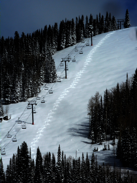 After receiving 9” Friday morning in town, and another 2” Sunday morning, Milly and I headed up the Steamboat ski area to ski some powder.
Parking at the base of the Thunderhead lift, we hiked about 90 minutes on Alpine Touring gear to reach the Four Points lodge, rested, and caught First (and only at that time) tracks next to the Storm Peak liftline.
There was about a foot of medium-density snow with a bit of a crust, though the turns were bouncy and consistent. The chunky snow was flying around thigh-deep on the descent. The observant will notice the rest I took about half way down to fully enjoy the remaining turns.
The picture was taken from the bottom of Tornado Lane and you can see Milly’s paw prints bisecting my tracks!
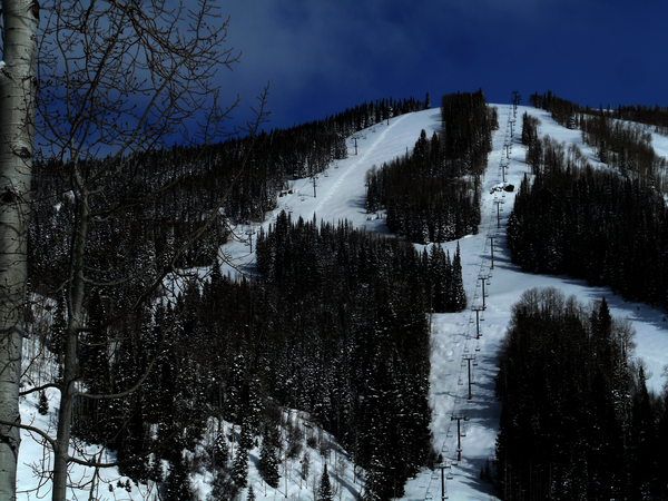 On the left is a panoramic shot of Tornado and the Four Points lift, with the very top of Nelson’s and Twister in view. The picture was snapped from Flatout near Surprise.
 The next day, while riding down the Core Trail to the gym, I noticed another skier had laid down some nice tracks next to mine.
I am heartened to see some powder etiquette and artistic skiing displayed as that seems to be sorely lacking these days!
Steamboat Springs area short term weather forecast from Monday night
Monday, April 18, 2016
This slow-moving storm, covering the western half of the country from the Pacific coastal mountain ranges to the Mississippi river and the Mexican to Canadian borders, will continue to bring cool and unsettled weather to our area through Wednesday.
There may be patchy fog in the valleys tomorrow morning before it clears, and some periods of sun similar to today. A lobe of energy that brought severe weather to the central plains Sunday night will finally move south over our area by tomorrow afternoon or night, after a circuitous route around the storm.
While the exact timing is still uncertain, non-accumulating snow showers are likely in the valleys during Tuesday afternoon and overnight and snow showers turning to periods of light to moderate snow are likely on the hill. We may see some clearing by Wednesday afternoon if the faster model solution verifies, but in any case I would expect 3-6” of snow on the mountain by the time the storm finally clears the area by later Wednesday.
A nice warm up is in store for the rest of the work week as spring briefly returns to the area, with possible rain showers Friday afternoon, before another storm threatens our area with inclement weather around mid-weekend. There is large model disagreement by then with the GFS bringing the storm south of us while the ECMWF is further north.
Steamboat Springs area short term weather forecast from Sunday night
Sunday, April 17, 2016
The storm-that-wouldn’t-leave is pretty much located directly over us, and there has been some clearing this afternoon under the hurricane-like eye of the storm. The storm will continue to sit and spin over or near our area for the next 2 days before finally moving east of our area around Wednesday.
There may be some snow showers overnight with no accumulations expected. Snow showers will continue Monday, and will become heavier and more frequent in the afternoon as any surface warming destabilizes the atmosphere.
It looks like we will see a short-lived break in the snow showers early in the day Tuesday before a lobe of energy, likely to bring severe weather to eastern Texas, Oklahoma and Nebraska overnight tonight, will take the long way to our area, first moving northward and reaching Montana Monday night before curving south by the Tetons and bringing likely significant snow, at least to the mountain, later Tuesday or early Wednesday.
There is now disagreement on when this energy will arrive, with the more consistent AVN bringing a last wave of snow Tuesday afternoon and overnight, while the more mercurial NAM brings the energy in about 12 hours later. The earlier solution will likely bring some sun to the valleys by Wednesday afternoon while the later solution will delay the sun until Thursday.
A nice warm up is in store for the rest of the work week, with possible rain showers Friday afternoon, before another storm threatens our area with inclement weather around mid-weekend.
Steamboat Springs area short term weather forecast from Saturday night
Saturday, April 16, 2016
This complex and lumbering storm, currently located in northern New Mexico, will slowly move north across Colorado Sunday and Monday before it ends up in central Wyoming by Tuesday. At this point, the storm finally begins to move east, bringing an end to the inclement weather over our area and an apparently short-lived return to spring later Wednesday.
Only light snow with minimal accumulations has been observed in Steamboat Springs Friday night and during the day Saturday as the storm sunk further south than originally forecast, keeping the TROWAL originally predicted to bring us possibly significant snow to our south and west. I still think we will receive some snow tonight, though amounts will be an inch or less in the valleys and 1-4” on the mountain, with some still significant snow overnight for the Front Range foothills.
Light snow showers should continue during the day Sunday before becoming more intermittent and weak overnight and lasting through Monday. There is a possibility of showers becoming heavier in the afternoon Monday as any surface heating during the day will further destabilize the atmosphere.
Strong storms over Kansas and Texas on Sunday will inject a batch of moisture into the upper atmosphere that will form a TROWAL as it rotates counterclockwise around the storm. This precipitation-maker will take the long way to our area, first moving northward and reaching Montana Monday night before curving south by the Tetons and finding its way into our area later Tuesday.
Ahead of this TROWAL, precipitation will decrease substantially overnight Monday and we may even see periods of sun during the first half of Tuesday before afternoon showers appear. Coincident with the main storm finally moving east and bringing favorable northwest flow to our area, the TROWAL will move overhead, bringing a round of possibly significant snowfall, especially on the mountain, overnight and into Wednesday morning.
Warming and drying is still forecast from Wednesday afternoon and into the beginning of next weekend before another storm threatens around mid-weekend.
Steamboat Springs area short term weather forecast from Friday night
Friday, April 15, 2016
The very complex and still intensifying storm, now centered over northern Arizona, will continue winter impacts over our area through Monday with snow showers tapering off on Tuesday before we see a few days of warming and drying starting around Wednesday.
The cold air last night along with the strong convective nature of the storm allowed snow levels to drop to the valley bottoms soon after the front passed yesterday evening, and what I expected as rain was pretty much all snow, leading to 8” on my deck this morning.
Looking ahead, low level counterclockwise winds around the storm will draw substantial Gulf of Mexico moisture northward and westward, creating conditions that produce a TROWAL somewhere over the Colorado mountains from Saturday through Monday and strong upslope flow over the Front Range. While all of Colorado will receive substantial precipitation, the foothills look particularly favored with several feet of snow by Sunday morning. There have already been road closures on I-70 and difficult to impossible travel will persist through Saturday night.
Closer to home, snow showers may continue overnight with another inch or so of dense snow in the valleys by Saturday morning and an additional 2-5” on the mountain as the winds turn easterly and strengthen. While we are often sheltered from precipitation when easterly winds downslope off the Park Range, we can receive moderate to heavy precipitation under a TROWAL.
Models indicate the position of the TROWAL moving around through the weekend, so the periods of moderate to heavy precipitation will likely move around as well with breaks in the inclement weather. Current model solutions have snow intensifying again later Saturday afternoon into the overnight hours as the storm finally begins to weaken and lifts northward across Colorado. We’ll probably see another 3-6” of snow in the valleys by Sunday morning with 6-12” on the hill.
The heaviest precipitation will have likely ended for the Front Range by Sunday morning, and we will also see a decrease in precipitation over our area during the day Sunday. However the proximity of the slow-moving storm, eventually forecast to be in southern Wyoming by Tuesday, will continue snow showers, some perhaps moderate to heavy at times, intermittently through Tuesday night. Drier weather forecast by Wednesday afternoon before another major storm threatens next weekend’s weather.


