
Wet weather this weekend followed by almost summer-like weather for midweek
Friday, April 24, 2015
A wave currently traveling through northern New Mexico has brought moister air into our region, increasing the threat of afternoon storms today. Another far more significant storm is currently located along the West Coast around the US - Canadian border and will be be Colorado’s major weather-maker for the weekend and early next week.
This storm is forecast to elongate and split as it approaches the Great Basin on Saturday, eventually becoming a closed low later in the weekend and traveling slowly along the Arizona - Utah and New Mexico - Colorado borders. Temperatures will remain mild ahead of the storm even as cool air begins to filter into the region during the day Saturday. Showers should increase and eventually turn more persistent by later in the day and lasting overnight. Snow levels will initially be quite high, around 10,000 feet, before dropping overnight to around 8000 feet.
This storm does have some similarities with last week’s meteorologically impressive storm, though it is far weaker and faster moving. But unfavorable mountain-top easterly flow is again predicted again by later Sunday for our northern Colorado region, and that may end or limit precipitation for a while around then.
A trailing wave crosses through the area late Monday into Tuesday keeping unsettled conditions in place and increasing the chance of precipitation again, but the wind barely turns northwesterly and likely limits precipitation amounts. The cool air associated with this wave will keep temperatures seasonably cool through Tuesday, but sharp warming will lead to almost summer-like weather by Wednesday, with even the typical afternoon thunderstorms forecast for Thursday and Friday.
The storm I initially thought would impact us around May Day is now forecast to weaken and stay mostly to our north, yielding a pleasant weekend, but another warm Pacific storm approaches the West Coast around then and may bring more beneficial moisture to our region around the following midweek.
Hiking for spring powder
Wednesday, April 22, 2015
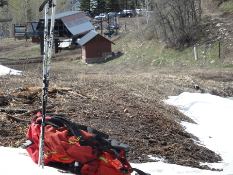 There are still spring powder turns to be had for those willing to hike. Shown to the right is about the 5 minute hike across bare ground needed to reach the snow on Lower Vagabond at the Steamboat ski area Tuesday afternoon. It is amazing how much this dried out from Sunday after recent snows, when you could start hiking from the lift terminal, but access to that was through a mud pit.
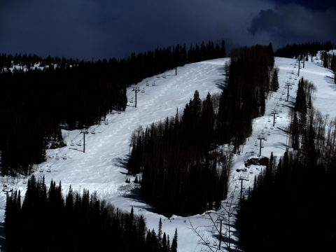 Speaking of Sunday, my tracks down the Storm Peak liftline on Tornado were clearly visible two days later as I hiked up from just above the Vagabond saddle! Skiing on Sunday was better than Tuesday as there was about 8-10” of dense powder from the weekend snows.
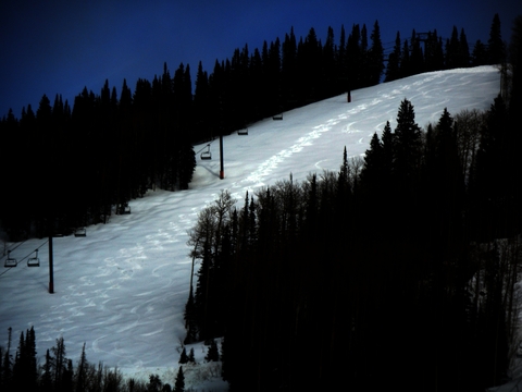 Shown to the right are Tuesday’s turns, where the 8-10” from Sunday consolidated to about 5-6” of even denser snow. I had started out intending to ‘8′ my tracks from Sunday, but the debris from Sunday’s turns made the skiing a bit inconsistent. About half of the way down, I sought the far more consistent untracked powder to skier’s left and finished the run next to my old tracks from Sunday.
 Milly, my hiking companion,
 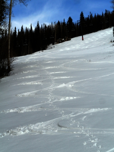 inspecting our turns on the lower slopes of Tornado. Note her paw prints bisecting my turns! She was the only one I could find to accompany me Sunday and Tuesday. If the snow allows it, she is always eager to help me start the season and end it!
Impressive spring storm continues with snows through tonight
Saturday, April 18, 2015
This very impressive spring storm continues with at least 2 more waves of snow for our area later this afternoon and overnight. The snows I thought may occur yesterday and Thursday night were overwhelmed by the strong winds downsloping from the east off the Park Range. In fact, you could see evidence of breaking atmospheric waves in the turbulent cloud structures overhead Thursday and Friday as the TROWAL was overhead. However, the upward motion from the TROWAL only briefly and intermittently appeared as the strong downward motion from the easterly winds dominated atmospheric motions.
But as the storm intensified and finally moved east of the Divide, another TROWAL moved over our area this morning. 2” of snow on my deck this morning and moderate to heavy snowfall rates on the hill in northerly flow resulted as this second feature gathered moisture from the Gulf of Mexico.
Models indicate another surge of moisture and upward motion later this afternoon that will produce another round of moderate to heavy snows. The kicker wave responsible for the eastward motion of this storm is currently in northern Montana, and will send more cool air through our area around midnight. This additional forcing will be far more moderate but will again produce snows for a time late tonight and decrease the snow densities, resulting in light fluffy snow on top of a dense base for Sunday. While the Steamboat Ski Area is notoriously guilty of closing just before we are impacted by these spring snowstorms, those willing to hike for turns will benefit.
The very active second half of April forecasted earlier this week looks to occur as the cold Canadian air to our north expands westward and southward and interacts with Pacific energy entering the West Coast. The persistent snow from this storm system will be replaced with showers tomorrow afternoon and Monday as moist and cool northwest flow remains over our area.
By Tuesday, another Pacific storm crosses the southern West Coast and will force the upper level winds to back to the southwest. But the current storm, even though by then forecast to over the Great Lakes region, will continue to affect us as waves of energy rotating around the storm continue to drag cool Canadian air over our area.
Showers midweek should turn to more persistent precipitation as the relatively warm Pacific air interacts with the cool Canadian air. The Pacific trough looks to cross our area around the end of the week when precipitation should be at its heaviest for this event.
But following closely on the heels of this southern system, another Pacific wave is forecast to cross the northern West Coast by the American GFS, again increasing precipitation for next weekend and lasting into the next workweek. The European ECMWF has a brief ridge crossing over our area before bringing a different wave across our area later in the weekend, so there is uncertainty for then. But in either case, drier weather will return only briefly as more Pacific energy crashes into the West Coast around May Day.
Evolving numerical guidance now includes the possibility of heavy snow Thursday into Friday
Wednesday, April 15, 2015
As discussed in yesterday’s forecast blog, model guidance has since evolved and we now have the possibility of heavy snows tomorrow afternoon extending into Friday. The American GFS has finally joined the other models in forecasting a consolidated circulation center that is currently spinning to our west. Furthermore, all models are now forecasting a more northward track of the cutoff low across Colorado which greatly increases our chance for significant snow.
The cutoff low is forecast to move southward along the Colorado - Utah border before being nudged eastward by the kicker wave mentioned yesterday approaching the West Coast. Even though the flow aloft will turn easterly for our area, this normally dry scenario can sometimes produce impressive snowfall when a TROWAL (TROugh of Warm air ALoft) develops. A TROWAL develops when warm and moist air is lifted ahead of the storm and rotates counter-clockwise around the parent low. The lifting of this elevated unstable layer over the cooler air near at lower elevations can create impressive precipitation rates, and it appears we may benefit from that process.
I do not have a lot of confidence in this solution since a small change to the track of the storm will change the location of this TROWAL. But the possibility exists for moderate to heavy snows from tomorrow afternoon through Friday afternoon. We may still get the 2-6” originally forecast for the hill, or we may get as much as 10-20”. Furthermore, the valley will also see significant snowfall if the wetter solution verifies.
Lastly, for those headed west for mountain biking, the slower and farther north solution offered by this morning’s model guidance would have the Grand Junction and possibly Moab areas wet through Friday, with cool conditions lasting at least through the weekend.
Summer-like weather ends tonight
Tuesday, April 14, 2015
After a couple of summer-like days, a strong cold front from a storm currently in central Nevada will bring winter-like days back to our area starting late tonight or early Wednesday and lasting possibly into the weekend.
Winds will increase through the day today before the front blasts through the region by tomorrow morning. At this point, there is a fair bit of uncertainty as the storm becomes separated from the jet stream along the Canadian border and evolves into a cutoff low. Because cutoff lows are removed from the strong and relatively predictable jet stream, their evolution is notoriously difficult to predict. Some models have this low further splitting into a couple of circulation centers that move around our area while others have a more coherent system staying mostly south and west of our area.
The strong front will drop snow levels to the valley bottom, even though upward forcing over our area is relatively benign. But the very cold air aloft will destabilize the atmosphere, and may lead to some localized areas of moderate to heavy snow as small storms develop. Generally though, I would expect only modest accumulation on the hill for the entire event, perhaps in the 2-6” range between Wednesday and Friday afternoon.
While some models have clearing by Friday night, there is no well defined movement of the cutoff low which means we may feel its effects into the weekend. A kicker Pacific wave is forecast to approach the West Coast later Friday and will force the cutoff low east of our area either late Friday or sometime Saturday.
This Pacific wave will split as it makes landfall, and may drag some cool air over our area on Sunday leading to showers for most of the day. But the main effect from this wave will be to phase with cold air over the central Canadian plains and begin a pattern change that may bring an active weather pattern for the rest of the month.
Specifically, as the cold air moves southward over the Midwest, a West Coast ridge rapidly rebuilds and becomes unstable, allowing Pacific energy to enter the west coast in a coherent manner next week. This energy is forecast to eventually interact with the cold Canadian air as the storms move eastward, leading to the possibility of a couple of major precipitation events near the end of the next workweek and again about a week later just before the end of the month.
Due to the number of interactions between different airmasses, and the fact that any interaction will influence future interactions, the forecast is very uncertain. However, my confidence is increasing that an active weather pattern may return for the second half of the month.


