
Midweek storm trending stronger
Monday, November 9, 2015
A splitting storm is currently located over the Pacific Northwest and will move across the Great Basin on Tuesday. While this was advertised in last week’s forecast, models are now placing most of the emphasis on the southern part of the storm, which looks to produce another round of moderate to sometimes heavy snowfall for the Steamboat Springs area.
After another pleasant day today, temperatures should be cooler tomorrow before showers begin in the late afternoon or evening. There should be a burst of heavy snow when the cold front passes around midnight Tuesday, and continuing moderate to sometimes heavy snow in windy conditions overnight as the atmosphere destabilizes in cold northwest flow. There may be as much as 6-12” on the hill by Wednesday morning and around half of that in the valley.
The snowfall rates will decrease and snow will become more showery during the day Wednesday as the storm moves eastward, though snowfall may increase a bit early Thursday as a trailing wave keeps cold air and instability over the Steamboat Springs area. These snow showers should end by Thursday afternoon, but not before leaving another 2-5” of snow on the hill by then.
Temperatures will start cold on Friday morning, but there should be some warming during the day, especially at the higher elevations as the Steamboat Springs valley may stay cool as the usual wintertime temperature inversion form.
Beautiful weather looks to be on tap for the weekend and possibly the early part of next week before another Pacific storm is forecast to make landfall around Monday.
First turns of the 2015-2016 season!
Sunday, November 8, 2015
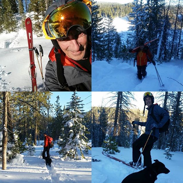 First turns of the 2015/2016 ski season on Saturday, 7 November after presumably the last mountain bike ride of the season on the previous Tuesday, 3 November! That beats last year’s 5 day break between summer and winter sports by two days!
The storm responsible for this quick switch dropped about 17 inches of snow over 3 days at the top of the Steamboat Ski Area as well as this location, which was at the upper end of the advertised forecast.
This area is Fox Curve which is on the east side of Rabbit Ears Pass several miles east of the West Summit. After a few uphill traverses without skins, we took off our skis and followed the bootpack up to the top of the ridge.
Below is some video evidence my buddy Dave Moloney shot as I was coming down the shallow ridge - The skiing was not nearly as good as last year, but bottomless powder on day 1 is always a good thing!
Milly followed Dave down ahead of me, so she was unavailable for the starring role this year.
Warming and drying for the weekend before a splitting storm approaches early next week
Friday, November 6, 2015
I had about 5” of snow on my deck this morning, and the powdercam at the top of the Steamboat Ski area is currently showing about 15” of storm snow with about 6” of that occurring between yesterday evening and this morning. Temperatures will stay cool today even as the snow tapers off on the hill and peeks of sun appear in the valley this afternoon.
After a chilly start Saturday morning, temperatures will begin to warm under clear and sunny skies, though still staying seasonably cool through the end of the day. Sunday morning will also start cool, but should eventually be warmer than Saturday as the center of a transient ridge moves over the Steamboat Springs area.
By Sunday, another strong Pacific storm brings more cold air and precipitation to the northwest coast and northern California as it moves eastward. Current model timing has the pleasant weekend weather lasting through Monday before showers are forecast beginning Tuesday. Unlike this past storm, models are forecasting that this storm will split as it crosses the Great Basin which may minimize the snowfall over northern Colorado. At the very least, temperatures will drop by Wednesday as the northern part of the split storm drags some cool air over our area.
Another shallow wave in the jet stream passes north of our area around Thursday, keeping the cool temperatures around for Friday as well. Current model forecasts have another round of warming and drying for the following weekend.
Storm lasts through Friday before warming and drying returns for the weekend
Thursday, November 5, 2015
I had about 2.5” of snow on my deck this morning, and the powdercam at the top of the Steamboat Ski area is currently showing about 8” of snow with a temperature of 12F. Weather will remain cloudy and cool today before a trailing wave brings another round of colder air and snow starting tonight and lasting through midday Friday, leaving an additional 3-6” on the hill and an inch or two down in the valley.
After a chilly start Saturday morning, temperatures will begin to warm under clear and sunny skies, though still staying seasonably cool through the end of the day. Sunday morning will also start cool, but should eventually be warmer than Saturday as the center of a transient ridge moves over the Steamboat Springs area.
By Sunday, another strong Pacific storm brings more cold air and precipitation to the northwest coast and northern California as it moves eastward. Current model timing has the pleasant weekend weather lasting through Monday before showers are forecast beginning Tuesday. There is model disagreement as to how fast this system moves through the area, but this is another cold storm that will produce snow Tuesday and perhaps Wednesday as well.
Storm arrival delayed until later Tuesday
Sunday, November 1, 2015
The storm advertised in the last forecast has trended slower in the models, and now is not expected to arrive until later Tuesday. The wet-weather forecast for Monday and Tuesday has now been replaced by breezy, dry and warm temperatures, with showers likely holding off till later Tuesday.
As before, the lead wave forecast to cross the area, now on Tuesday, will not have much cold air, keeping the initial surge of precipitation as rain in the valley and snow at the higher elevations, with maybe 1-4” at the top of Mt. Werner. By Wednesday, however, cold air infiltrates the area and lowers snow levels, with snow likely accumulating on the valley bottom by the end of the day Wednesday.
The mountain-top winds turn from the southwest to the northwest Wednesday evening, which should increase the snowfall rates, especially on the hill. I expect 3-6” of snow by Thursday evening at the Steamboat Ski area and maybe an inch or two in town.
There is a small break Thursday night before another wave in northwest flow brings more snow and additional colder air for Friday, perhaps leaving another inch or so in town and an additional 3-6” on the hill.
The weather is forecast to clear for Saturday, and after a chilly start, temperatures will moderate, especially later in the weekend. Seasonable temperatures with dry weather will last through Monday before the next storm threatens the Steamboat Springs area around Tuesday or Wednesday.


