
Good rain chances to last through the workweek
Sunday, August 24, 2025
Temperatures are in the upper-seventies with cloudy skies this Sunday mid-afternoon in Steamboat Springs. You don’t have to be a meteorologist to know the weather pattern has shifted, with our best monsoonal surge of the summer arriving today and lasting through the workweek. While some rainfall is almost certain over the entire state, timing, rainfall rates, and duration are uncertain, as is often the case during the North American Monsoon.
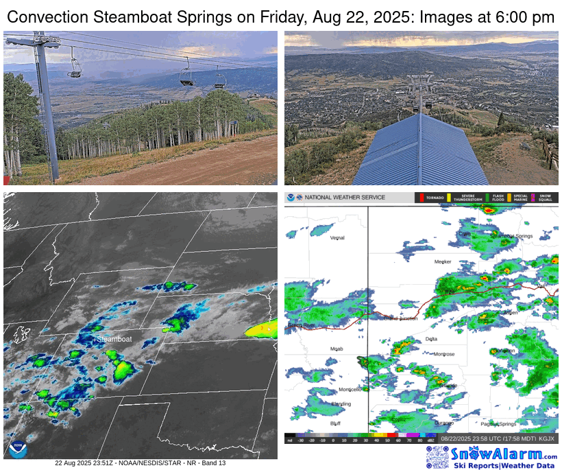 Before discussing the weather forecast, the thunderstorm last Friday exhibited similar characteristics to those that occurred exactly a week ago, when a thunderstorm rapidly intensified as it moved over town, approaching this time from the northwest rather than the southwest.
The image in the lower-left of the mosaic animation is the infrared satellite, which measures cloud-top temperatures; the higher the cloud, the colder the temperature, the more colorful the image, and the stronger the thunderstorm. The location of Steamboat Springs is marked in white, and the rapid intensification of the storm cell is noted by the rapidly growing green blob that moves over town. The propagation of the storm through town is captured first by the sequence of images from the Thunderhead cam in the upper right as the rain approaches from the northwest, and then the Four Points cam in the upper left as it moves over the Steamboat Ski Resort.
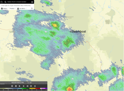 While the red colors of the radar images in the lower right panel indicate a strong storm, it is apparent that the cell splits as it moves over town. The second animation shows a high-resolution radar view of the splitting storm. Not only does the initial thunderstorm split when it moves over town, but additional thunderstorms from the north merge with both parts of the split storm, illustrating the difficulty in making even a real-time forecast, or nowcast, of shower development.
But now we are in a new weather regime as the ridge of high pressure responsible for the record-breaking heat last week is forced eastward by low pressure approaching the West Coast. Clockwise flow around the high pressure has conspired with southerly winds ahead of the approaching low pressure to bring a surge of monsoonal moisture northward.
Good rain chances starting this afternoon and lasting through much of the workweek result, with high temperatures cooling into the upper-seventies on Monday and Tuesday, near our average of 79 F, and lower-seventies on Wednesday and Thursday. Overnight rainfall is possible, even likely at times, with the strength of daytime thunderstorms dependent upon morning cloud cover. Morning sun will cook the moist atmosphere, allowing stronger thunderstorms later in the day, while morning clouds will allow for a gentler and steadier rain.
The best day for showers is Wednesday, which is incidentally the coolest day of the week, as the low pressure off the West Coast is forced inland by a storm moving southeastward through the Gulf of Alaska. This is also when snow levels drop below 14,000′, perhaps leading to the first dusting of snow on Colorado’s highest peaks Thursday and Friday mornings.
Rainfall for our area is forecast to be significant, between one and one-and-a-half inches, and is sorely needed. The monsoonal moisture tap is forecast to be severed by the end of the work week by westerly winds associated with the Gulf of Alaska storm as it approaches the Pacific Northwest, bringing a warming and drying trend into next weekend.
Let’s hope the moisture arrives beneficially with light to moderate rainfall rates, as heavy downpours will be problematic around recent burn scars. Relish the wet workweek ahead, and I’ll have more details about the weekend’s forecast in my next regularly scheduled weather narrative on Thursday afternoon.
After record heat, temperatures to cool with shower chances for the weekend
Thursday, August 21, 2025
After a fourth straight day with temperatures in the nineties, clouds have appeared this Thursday mid-afternoon in Steamboat Springs as a monsoonal push of moisture begins. Temperatures are forecast to fall into the mid-eighties on Friday and the weekend, with shower chances best on Friday. But significant precipitation becomes very likely next week as temperatures fall into the seventies.
Record high temperatures were set in town this week; while the ninety degree high on Monday was the second warmest behind the 94 F in 2020, Tuesday’s high of 93 F broke the 91 F record set in 2020, Wednesday’s high of 94 F shattered the 90 F record set in 2023, and today’s record of 91 F, also set in 2023, is in jeapordy. The three-day 92.3 F average high temperature for Monday through Wednesday was the 16th warmest three-day stretch since 1893, with the hottest being a blistering 97 F for the three days ending on August 8th and 10th in 2001. August 2001 was an all-time scorcher, holding eight of the twelve hottest three-day stretches and the top four spots.
Fortunately, the lack of wind with these record temperatures kept the growth of the surrounding wildfires in check, allowing containment of the Lee Fire to increase from 42% Sunday to 73% today, and the Crosho fire to increase from 5% Sunday to 24% today.
A storm traveling from the Canadian Plains toward the Great Lakes has flattened a ridge of high pressure over the West, with clockwise flow around the high carrying monsoonal moisture first northward into Nevada, then northeastward into Utah, and eventually eastward into Colorado. A couple of waves rotating around the Canadian storm will increase shower chances Friday afternoon and evening, with high temperatures cooling into the mid-eighties, still above our average of eighty degrees.
Similar temperatures are forecast for Saturday and Sunday, with decreased shower chances on Saturday being followed by increasing shower chances later Sunday. A wave ejecting from a storm in the Gulf of Alaska is forecast to slide southward off the West Coast early in the weekend before moving eastward, nudging the high pressure eastward and substantially increasing the flow of monsoonal moisture northward.
Significant precipitation is expected for the next workweek, with rainfall rates uncertain and likely to depend on cloud cover, potentially ranging from one to two inches. Morning cloudiness will inhibit thunderstorm strength and lead to a steadier rain over a longer time, while less cloudiness will allow the lower atmosphere to heat and contribute to stronger thunderstorms, similar to the cloudburst from last Friday.
Enjoy the summer weekend ahead, and I’ll have more details on this encouraging monsoonal push in my next regularly scheduled weather narrative on Sunday afternoon.
Hot and dry weather to return for the workweek
Sunday, August 17, 2025
Comfortable temperatures around eighty degrees with partly cloudy skies are over Steamboat Springs this Sunday mid-afternoon. High temperatures are forecast to increase this workweek, approaching ninety degrees starting Tuesday, with rain chances near zero until the weekend when moisture is forecast to return.
A ridge of high pressure over the Mississippi Valley is moving westward and has bent the monsoonal plume of moisture that brought much-needed precipitation to our area eastward. Anybody around to witness the cloudburst on Friday evening that went right over the Steamboat Ski Resort? 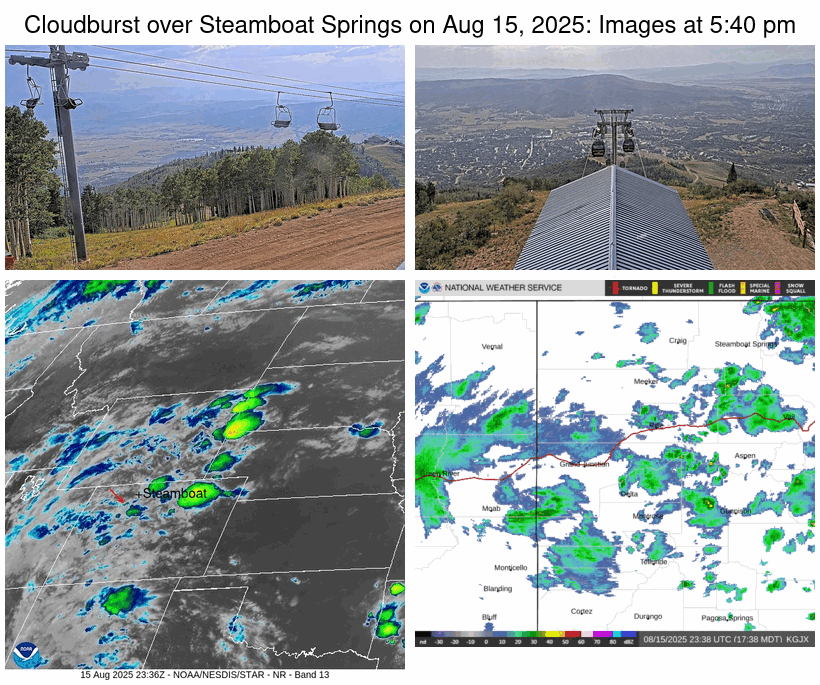 Shown is a time-lapse of the storm cell acquired from the cams at Four Points and Thunderhead Lodge, infrared satellite, and radar between 5:40 pm and 7:00 pm.
Immediately apparent is the striking rain shaft that traveled up the South Valley before reaching the Steamboat Ski Resort around 6:40 pm.
The image in the lower-left is the infrared satellite, which measures cloud-top temperatures; the higher the cloud, the colder the temperature, and the stronger the thunderstorm. I have added a small red arrow tracking the cell from when it was barely noticeable. The rapid increase in storm strength is also apparent in the radar images, which shows the cell moving right over town.
The darkening sky and rumbling thunder were clues that the storm was rapidly approaching and strengthening, and the instantaneous appearance of a sharp clap of thunder and lightning bolt at 6:40 pm marked the passage of the storm directly overhead. Over a third of an inch of rain was recorded at the base of the Thunderhead lift, and I suspect more fell just to the south.
But there is no hope for a repeat this workweek as a ridge of high pressure builds over the Rockies. High temperatures in town are forecast to be in the mid-eighties on Monday and approach ninety degrees for Tuesday through Thursday, above our average of eighty-one degrees.
While there was weekend progress in containing the Lee Fire, now over 137,000 acres and 42% contained, and the Crosho fire at 2004 acres and 5% contained, the increasingly hot temperatures will fortunately be accompanied by far less wind than last week. The NOAA Smoke model forecast indicates quieter fire activity and very little smoke through Monday night.
A storm in the Gulf of Alaska is forecast to rotate eastward through the workweek, eventually bringing some energy across the northern Rockies by the weekend. We may see some moisture associated with the southern part of the storm, and it is not yet clear how much the ridge of high pressure overhead may be deflected back to the east, possibly opening the door to another monsoonal surge of moisture.
Enjoy another summery week, as they will surely grow less frequent as fall approaches, and I’ll have more details about the possible weekend moisture in my next regularly scheduled weather narrative on Thursday afternoon.
Rain chances to persist through Saturday
Thursday, August 14, 2025
After high temperatures in the upper eighties with mostly sunny skies early this Thursday afternoon in Steamboat Springs, a monsoonal plume of moisture has brought cloudy skies, cooler temperatures, and increasingly gusty winds from nearby thunderstorms by mid-afternoon. Rain will have a tough time reaching the ground today due to the very dry lower atmosphere, with better chances on Friday and Saturday as high temperatures cool, reaching only the low-eighties for the weekend. A pleasant Sunday will be followed by dry weather and rising temperatures to start the workweek.
Some energy previously left behind off the California coast by a storm now crossing the central Canadian Plains is being forced eastward over the West Coast by a new storm moving through the Gulf of Alaska. The energy will be deflected northeastward as it crosses the Great Basin by a strong ridge of high pressure centered over the Lower Mississippi Valley, with monsoonal moisture carried northward by the southwesterly winds east of the low pressure and the southerly winds west of the high pressure.
High temperatures will cool several degrees into the mid-eighties on Friday, still above our average of eighty-two degrees, with a better chance of rain from thunderstorms reaching the ground as the incoming California wave interacts with energy and moisture moving up from the south.
The upper-level energy may keep storm chances going through the evening, and according to the latest short-range weather forecast model, possibly on Saturday morning as well. High temperatures will cool to average, with continued storm chances through Saturday, until the monsoonal moisture plume is bent eastward by the passing California wave, bringing drier air overhead with continued comfortable temperatures on a mostly sunny Sunday.
The likely limited moisture, gusty winds, and lightning are not good news for the Lee Fire near Meeker, now over 127,000 acres and only 3% contained, and the newer Crossho Fire near Yampa, at 1,700 acres with no containment, though the cooler daytime temperatures and increased humidity might help.
Hope for rain, enjoy the cooler weekend temperatures, and I’ll have details on what is looking like another hot and dry workweek in my next regularly scheduled weather narrative on Sunday afternoon. And before finalizing your outdoor plans, be sure to check the NOAA Smoke model forecast, run four times a day, for the latest smoke plume trajectories.
Dry and hot ahead of increasing moisture starting Thursday
Sunday, August 10, 2025
Partly sunny skies with comfortable temperatures in the mid-seventies are over Steamboat Springs this Sunday mid-afternoon. The smoke plume from the Lee fire, mapped at over 106,000 acres and six percent contained, and the Elk fire, mapped at over 14,000 acres and nine percent contained, was pushed to our south along the I-70 corridor by a couple of cool fronts on Friday and Saturday nights. It should stay to our south for at least a couple of days as temperatures rise into the upper eighties by Tuesday, with hot temperatures persisting through much of the workweek. Some monsoonal moisture is forecast to begin moving overhead starting Thursday, peaking by Saturday, with chances for meaningful moisture reaching the ground uncertain but likely on the low side.
An area of low pressure extends southwestward from the southern shores of Hudson Bay to the Desert Southwest, while an area of high pressure sits off the west coast of North America. Cool air from western Canada was brought into our area by northwesterly winds this weekend, bringing the comfortable temperatures associated with our first northwesterly cool fronts of the season, and pushing the smoke plume from the wildfires near Meeker to our south.
Clearing skies tonight should bring chilly overnight temperatures in the upper-thirties to town by Monday morning, below the forty-five degree average, especially in the favored low-lying areas of the Yampa Valley. High temperatures are forecast to rise to around our eighty-two-degree average on Monday with mostly sunny skies, as high pressure begins to build over the West behind the departing trough.
Even warmer temperatures in the upper eighties are forecast for Tuesday, with wildfire smoke forecast to stay away on both Monday and Tuesday as winds retain a northerly component. Temperatures are forecast to approach ninety degrees on Wednesday and Thursday as the ridge moves eastward, bringing westerly breezes that make the smoke forecast uncertain. Check the NOAA Smoke model forecast, run four times a day, for the latest forecast smoke plume trajectories.
Meanwhile, a wave of energy ejects from an area of low pressure in the central Pacific, mixes with some cool air north of the Bering Straight, and develops into a new area of low pressure off the west coast of North America by midweek. Winds ahead of the low pressure and behind a building ridge of high pressure over the Southeast will encourage moisture from the Mexican Plateau to move northward, bringing a weak monsoonal surge of moisture to our area that begins Thursday and peaks Saturday.
So thunderstorm chances begin by Thursday afternoon, with the best chance of wetting rains holding off until later Saturday. Unfortunately, even then, storms are most likely to produce more wind than rain, a depressing forecast for controlling the wildfires near Meeker.
Enjoy the cooler temperatures today and Monday, hoping the firefighters can take advantage of the opportunity to achieve greater containment of the Meeker wildfires. I’ll have more details on the coming monsoonal surge of moisture in my next regularly scheduled weather narrative on Thursday afternoon.


