Light snow for most of the next week
Thursday, February 22, 2018
The active weather pattern for Steamboat Springs will continue through next midweek as cold air from western Canada continues to mix with incoming Pacific storms. Several storms are lined up to bring mostly light snow and more cold temperatures to our area starting this afternoon and lasting through the first part of Sunday, with a small break advertised Saturday morning.
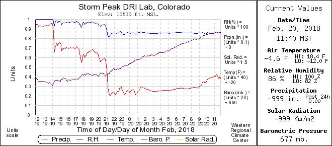
Before discussing the weather forecast, I’d like to show the temperature timeseries at Storm Peak Lab near the top of the Morningside lift from last Tuesday when a series of cold fronts blasted through northern Colorado.  The red line is the temperature, the vertical scale ranges form -20F to 20F with each tenth representing 4F, and the horizontal timescale ranges from noon on Tuesday through noon on Wednesday. The initial cold front passed through the area around 2pm Tuesday with heavy snow, dropping temperatures from 18F to 6F in minutes and leaving about 4” of snow on the hill through that afternoon. Cold air continued filtering in until another strong push of cold air brought the lowest temperatures of the storm of -12F around 9pm. I had expected another 3-6” of snow overnight with that front, but the very cold temperatures changed the snowflakes from light and fluffy dendrites to dense needles and columns. Rather than snow densities of 30:1 or 40:1, the resultant 10:1 densities meant only about an inch of snow overnight, underscoring the difficulty in predicting snow amounts. Generally, our best accumulating snowfall occurs with mountain-top temperatures between about 5F and 15F.
Back to the current forecast, energy ejecting out of a large storm dropping into the Great Basin will start snow showers over Steamboat Springs later this afternoon as a weak cool front passes through tonight. I would expect 1-4” by the Friday morning report.
The Great Basin storm is pushed eastward by another incoming Pacific storm, keeping light snow showers going during the day Friday before a cold front associated with the storm increases snowfall rates for a time Friday night. I would expect another 3-6” of snow by Saturday morning before a brief break in the weather is advertised for a cold Saturday morning.
The last Pacific storm for the weekend brings another weak cold front through our area Saturday night or Sunday morning, restarting the snow showers by Saturday afternoon that last through Sunday morning. The timing of the front will determine if we get most of the expected 3-6” by report time or by later in the morning.
Yet another Pacific storm moves southward from the Gulf of Alaska late in the weekend along the West Coast, and turns our flow to the southwest early in the work week. We should see dry weather and warming temperatures from later Sunday through at least part of Tuesday before this storm is kicked over our area by another Pacific storm entering the Gulf of Alaska. The warming ahead of the storm will allow a good cold front to pass through the area around Tuesday night or Wednesday, with more accumulating snows likely.
Save your soles! If you do any walking in your ski boots on hard surfaces, then you know the grating and grinding sounds you hear can’t be good. In fact, worn boot soles make your binding unsafe as it interferes with the boot-binding interface. Cat Tracks are a flexible protector that keeps your boot soles pristine, and adds a cushion for walking comfort. When it’s time to click into bindings, I take them off and stash them in my coat pocket. Yaktrax
are similar, but I have not used them since they appear they would take up a bit more space in my jacket pocket. But you get a rocker sole that promotes a natural stride which may be worth the space sacrifice. If I did not have to carry them around all day, these would be my choice.
Add comment
Fill out the form below to add your own comments


