
Quick moving storm around Friday followed by large complex slow moving storm next week
Wednesday, October 28, 2015
The active jet stream advertised in last week’s forecast will continue to affect the Steamboat Springs area late Thursday into Friday with a quick moving storm, followed by a large, complex and slow moving storm starting around Monday and lasting through much of the next work week.
A wave currently crossing the West Coast will split as it crosses the Great Basin, keeping most of the precipitation to our south. Some cool air from the the northern part of the split will be reinforced by additional energy moving across the Pacific, but overall the winds never turn to our favorable northwest direction, limiting the cold air and overall precipitation. The end result is showers should begin Thursday afternoon or evening and leave 1-4” of snow on the upper part of the hill by noon Friday, with lesser amounts at lower elevations and rain in the valleys.
Drier weather with average temperatures will return after this storm passes from Friday afternoon through the weekend, with perhaps breezy conditions at times.
However, this break will end by Monday morning as a large storm forecast to be off the Northwest Coast by Sunday afternoon moves south and east, reinforced by a number of upstream waves crossing the Pacific. Some of these waves will be be ejected out of the parent storm, forecast to be located around mid-California by Monday, and move over our area, with the first wave forecast by early Monday morning.
Currently, models forecast most of the precipitation to fall as rain in the valley bottom as a relatively stationary front settles over our area, but likely significant snow at the higher elevations for Monday and most of Tuesday. However, it looks like Steamboat Springs will be right on the edge of the rain-snow elevation, and precipitation may switch to snow during the overnight hours before changing back to rain during the day.
A large piece of energy is forecast to move along this front by Tuesday night, likely keeping precipitation as snow along the valley bottom by Wednesday. Continued precipitation is expected for Thursday and possibly Friday as this storm eventually moves eastward and likely south of our area, but the complexity evident early in week greatly reduces forecast confidence beyond midweek.
Cool and unsettled through next weekend
Friday, October 23, 2015
An active jet stream has settled over our area and is forecast to persist through next week and the following weekend, bringing periods of rain and higher elevation snow every several days. After this storm clears the area later today, dry weather with seasonable temperatures are forecast for this weekend.
But a series of waves in the eastern Pacific will interact in a complicated manner and eventually push through another cold wave by Monday, bringing more precipitation to the area after the weekend ends. A trailing wave later Tuesday may bring the coldest air of the season into the Steamboat Springs area later Tuesday and into Wednesday, possibly producing some snowflakes in the Yampa Valley by Wednesday.
Brief ridging on Thursday should give us a break before another warmer Pacific wave takes aim on the California coast, bringing much needed precipitation to that area before moving across the Great Basin and possibly affecting us by Friday.
The inclement weather will be briefly interrupted around the weekend before another wave threatens our area with more precipitation by around Monday, The European ECMWF is forecasting a more southward trajectory for this storm compared to the American GFS, and may keep the storm too far south to bring precipitation to our area.
Some recent pictures of our stunning fall
Saturday, October 17, 2015
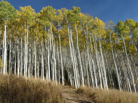
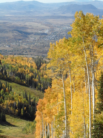 I have lots of pictures I need to go through more systematically, but here are six that I quickly grabbed. To the right is our fair town of Steamboat Springs on 25 September as seen from the Sunshine trail as it cuts across Twister. Elk Mountain, also know locally as Sleeping Giant, can be seen just above the aspen tree to the right!
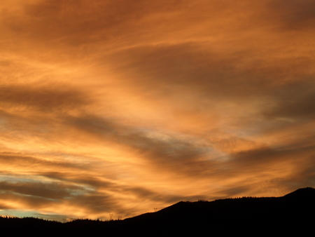 Here is a beautiful sunset seen from the lower half of Gunsmoke on the lower mountain taken on 1 October.
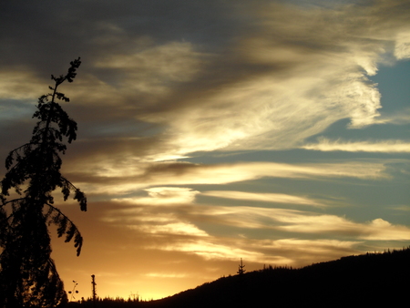 Another sunset taken from a similar place on Gunsmoke, but a week later on 9 October.
 Steamboat has really spent considerable time developing new mountain bike trails on the hill, and this is a new trail that starts at the base of Pony Express and winds through Pioneer Ridge before ending up at Rainbow Saddle. I’d call the trail Prime Rib if it were up to me since it cuts across Middle Rib and the trail has some of the best single track on the hill! Incidentally, the moose on the ‘Big Moose, litlle moose’ post was located along this section of new trail, though this was taken on 21 September.
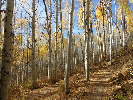
 This is near the top of the new trail as it enters the aspen forest around Twister on 21 September.
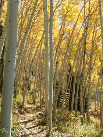 Surprisingly, this was taken on 27 September on the new trail as it winds through the aspen around the Pony Express chairlift. There are a lot of aspen on this trail that change color at different times, lending spectacular color from the lastweek of September through mid-October.
More seasonable weather returns during the weekend
Thursday, October 15, 2015
Our run of spectacular fall weather looks to be interrupted starting this weekend as the week-old storm that passed south of our area last weekend and spent some vacation time in Baja this week is forced eastward across the Great Basin by an upstream Pacific storm.
Before this happens, though, the current unseasonably warm and dry weather will persist through tomorrow and likely most of Saturday. As the lingering storm from last week crosses the Great Basin, it weakens considerably as it interacts with the current ridge of high pressure covering the Rockies, but will first spread high clouds over our area on Friday and then deeper moisture by Saturday, which should cool temperatures from their near-record highs.
There will be a chance of showers Saturday afternoon and evening as what remains of this storm passes over the area. By Sunday, the Pacific storm crosses the West Coast, and devolves into an unorganized storm system that will span the nearly the entire third of the North American continent as it barrels into and around the ridge.
While the details will almost surely change in such a complicated forecast, unsettled weather with mostly seasonable temperature will persist from Saturday night through Tuesday, with the best chance of showers currently forecast for later Monday and Monday night as some energy moves over the area.
Some of this storm gets left behind in the southwest around midweek, leading to a nice break in the weather then. However, that storm paired with another storm approaching the West Coast by the end of the work week may threaten next weekend’s weather.
Spectacular weather for the next week
Thursday, October 8, 2015
A straightforward forecast for a change as the jet stream is forecast to stay north of the Steamboat Springs for the next week. There are a couple of dry waves traveling well north of us this afternoon and again Sunday afternoon, and we may get some cooling and increased winds from those systems. Otherwise warm and dry weather will grace our area through the most of the next work week.
Interestingly, the cutoff low to our south which brought the cool and showery weather earlier this week is forecast to move south and west, eventually ending up near Baja by early next week. There is modest agreement between the models that this storm will eventually be forced to the northeast across the Great Basin by a quick-moving storm in the eastern Pacific by midweek.
There will likely be interactions between the Pacific and Baja storms, with details becoming clearer as we head through next week. But it appears these two systems may threaten our warm, sunny and gorgeous weather by the end of the work week and for the following weekend.


