
Rain likely today and tomorrow with decreasing chances through the weekend
Thursday, July 24, 2014
A moist monsoonal moisture plume has invaded our area over the last 24 hours which will increase the threat of rain and make it likely, especially for today and possibly for tomorrow as well. Coincidentally, an upper level low currently along the northwest US - Canadian border has flattened the summertime ridge over the Rocky Mountains and will provide further energy for organized storms, especially tomorrow afternoon, with some of these storms possibly persisting in the evening before ending later that night.
This wave to our north will bring seasonably cooler temperatures to our region through the day on Saturday and especially for Sunday. Showers may occur Saturday though the cooler air forecast for Sunday may preclude shower development.
As the upper level low along the Canadian border continues its eastward progress, the western ridge rebuilds and drags another plume of monsoonal moisture northwards for Monday and Tuesday. Additionally this surge will be accompanied with some upper level lifting from the south which will substantially increase the chance of significant rains for those days.
There may be a break in the monsoonal pattern around midweek before it looks to become re-established for next weekend, though there is a fair bit of uncertainty in the model forecasts for that time period.
Standard summer weather on tap for the next week
Thursday, July 17, 2014
Fairly standard summer weather is forecast for our area over at least the next week. Cool air left behind by the passing wave on Wednesday will keep showers away for today, but the threat of afternoon storms returns for Friday and the weekend as the summer ridge rebuilds over our area and draws moisture from the south over Colorado.
A passing wave well to our north on Monday interrupts this monsoonal flow for a day or two, but atmospheric moisture re-establishes itself by midweek leading to an increased chance of afternoon or evening storms.
Monsoonal surge brings greatest chance of showers on Friday
Wednesday, July 9, 2014
Atmospheric moisture has substantially increased in the last 24 hours as the clockwise circulation around a ridge over the Rocky Mountains draws moist air northwards into our area. This increase in moisture combined with high afternoon temperatures will lead to an increasing chance of showers this afternoon and extending through the end of the workweek. Additionally, a wave moving along the Canadian border on Friday will increase the likelihood and strength of showers, making that day the wettest day of this forecast period with showers possibly developing as early as noon.
Though this monsoonal moisture is suppressed to our south with the passing of the Canadian wave for the weekend, there should be enough existing moisture for a small chance of slow-moving afternoon showers on Saturday with even less of a chance for Sunday.
Next Monday will be similar to the preceding Sunday before that Canadian wave intensifies and moves into the upper midwest early in the workweek. This will again increase the likelihood and strength of showers for Tuesday and Wednesday of next week. After that, models forecast westerly flow aloft which will cut off the monsoonal moisture plume and allow for drier conditions heading into the following weekend.
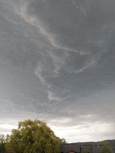
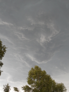
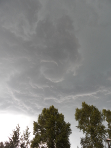
Independence Day funnel clouds in Steamboat Springs
Saturday, July 5, 2014
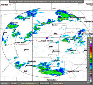
Fireworks in Steamboat Springs started ahead of schedule on late Friday afternoon as funnel clouds appeared over the the south part of town around 5:30 pm MDT. These photos were taken on Village Dr, first near Meadow Lane and then about 1/4 mile north near Walton Creek Rd. As the radar loop from Grand Junction in the lower right shows, the storm rapidly gained strength soon after 5:09 pm MDT and was quite strong between 5:28 and 5:48. During this time, rotation was evident in several areas of the cloud base, and it appeared that 2 or 3 shallow funnels briefly formed around this time. Along with favorable wind shear that helped cause the rotation, atmospheric instability was enhanced as the storm formed along a dry-line that was present at the boundary of the moist monsoonal air to our south and some drier air to our north and west that appeared in the afternoon.
Chance of showers highest for July 4th holiday
Thursday, July 3, 2014
Moisture drawn from our south is currently increasing over our area, leading to a small chance of showers this afternoon. The best chance, however, will occur during the July 4th holiday as the areal extent and chance for wetting rains will be the highest, especially in the afternoon and evening.
Dry air will interrupt this very brief monsoonal surge of moisture for the rest of the holiday weekend, though remnant moisture trapped under the dry air may lead to a very slight chance of storms for Saturday and Sunday afternoons.
Warm and dry days should follow the weekend until midweek or soon after when another slug of monsoonal moisture is forecast to make a brief appearance over our area, increasing the chance of wetting rains. A shortwave moving well north of us will then suppress the ridge to our south and return dry weather to our area for at least part of the following weekend. However, the southwest ridge builds behind this shortwave late in the weekend or early the following week leading to a more sustained monsoonal surge and increased chances of precipitation for our area.


