
Southern storm to graze our area Thursday
Monday, October 20, 2025
A bright, breezy and cool fall day is over Steamboat Springs after last night’s cold front, with temperatures in the mid-forties as of this Monday mid-afternoon. Warming temperatures and mostly sunny skies are forecast through Wednesday before a storm moving across the Desert southwest grazes our area with possible showers on Thursday. Nice weather returns to start the weekend ahead of a strong winterlike storm to end the weekend.
The grazing cold front early this morning dropped around a tenth of an inch of rain, lowering the high temperatures from the upper-sixties on a beautiful Sunday, about ten degrees above our average of fifty-seven degrees, to ten degrees below average today. Expect the coldest night of the season so far tonight, as light overnight winds and clear skies allow low temperatures to drop to around twenty degrees, around five degrees below our average of twenty-five degrees, and colder in the low-lying drainages.
The storm responsible for the cold front is forecast to quickly move from the Dakotas to the Great Lakes by late Tuesday before stalling and spinning over the Northeast through the rest of the workweek. A flat ridge of high pressure will move overhead through midweek behind the storm, allowing for mostly sunny skies and high temperatures warming into the mid-fifties on Tuesday and around sixty degrees on Wednesday, which should be the warmest day of the week.
Meanwhile, an eddy of low pressure off the coast of Baja, left behind by last week’s storm, is forecast to be nudged across the Desert Southwest by a couple of North Pacific storm moving across the Gulf of Alaska. Weather forecast models have struggled with the speed and location of the eddy, typical of eddies cut off from the main jet stream, but have settled on the eddy moving across the Four Corners by Thursday evening and the Oklahoma Panhandle by Friday night.
Clouds will increase by Wednesday night with some light showers possible on Thursday as the center of the storm traverses southern Colordao. High temperatures will only fall several degrees into the upper-fifties as, unsurprisingly, there is not much cold air associated with the Baja storm.
Nice weather returns for Friday and Saturday ahead of another North Pacific storm that is forecast to move across the Gulf of Alaska on Thursday and cross the Pacific Northwest coast on Friday. This will be the coldest storm of the season so far, with the storm crossing the Great Basin on Saturday and approaching our area by sometime Sunday.
Enjoy the nice fall weather through midweek, and I’ll have more details on the timing and strength of the approaching cold front, including anticipated snow amounts which are likely at all elevations, in my next regularly scheduled weather narrative on Thursday afternoon.
Cool start to a nice weekend
Thursday, October 16, 2025
Temperatures have only touched fifty degrees by this Thursday mid-afternoon in Steamboat Springs, with some clouds left over from last night’s cold front still lurking to our north. The cool temperatures and mix of sun and clouds will stick around on Friday and be reinforced on Saturday morning by a grazing, dry cold front. Mostly sunny skies and warmer temperatures close out the weekend for Sunday ahead of another grazing cold front to start the week.
After around a quarter-inch of rain fell in Steamboat Springs last night as a cold front passed through, a quintessential fall day has settled over the area, with breezy winds and high temperatures only around fifty degrees, below our average of fifty-nine degrees.
Cool, northwest flow will continue on Friday with similar temperatures and sky cover behind the storm and ahead of another approaching storm. However, weather forecast models have trended weaker and further north, leading to a grazing cold front on Saturday that will keep the cool temperatures around for another day. There may be some clouds to start the day, but mostly sunny skies are forecast by the afternoon.
A transient ridge of high pressure then moves over the West behind Saturday’s grazing cold front and ahead of a storm now over the Bering Sea, forecast to develop over the Gulf of Alaska by Sunday. Mostly sunny skies with high temperatures in the low sixties will make for a gorgeous fall Sunday. Like the grazing cool front on Saturday, weather forecast models have trended weaker and further north with the Gulf of Alaska storm, which is now predicted to bring another likely dry grazing cold front through our area on Monday.
An eddy of low pressure left behind from last night’s storm is eventually forecast to form off the coast of Baja, before being dragged across the Desert Southwest by midweek. The latest forecast indicates that the eddy will remain south of our area, but I’ll have more details on how this may or may not affect us in my next weather narrative on Monday afternoon, a day later than usual.
More precipitation chances for the workweek
Sunday, October 12, 2025
After nine-tenths of an inch of rainfall in Steamboat Springs over the last three days, punctuated by the town’s first snowfall of the season of three-quarters of an inch this Sunday morning, skies are clearing early this afternoon. Temperatures will struggle to reach fifty degrees today, but should approach sixty degrees on Columbus Day, despite good rain chances from the approaching remnants of another tropical storm that will continue into Tuesday. And, similar to this weekend’s storm, a cold front is forecast to follow around Wednesday night, continuing the unsettled weather for Thursday.
 Drier air behind a cold front last night has replaced moisture from the remnants of former Hurricane Priscilla, which brought three-quarters of an inch of rain to town yesterday. While the cold front was well-advertised, its strength was underestimated until yesterday afternoon, as cold air moving southward from western Canada was split between the storm moving across the Great Basin and a new storm forming near Vancouver.
While I was not surprised to see snow in town this morning based upon yesterday’s guidance, I was surprised that the snowfall exhibited very little elevation dependence, as both the upper mountain and mid mountain received two inches, compared to the three-quarters of an inch in town. In hindsight, strong cold fronts that are not followed by orographic, or terrain-driven precipitation, often can bring similar snowfall to all elevations.
The storm over Vancouver is forecast to strengthen as it moves southward along the West Coast, forming an eddy over San Francisco by Monday night. Similar to this past weekend, moisture from the remnants of another tropical system near Baja, former Tropical Storm Raymond, will be drawn northward and over our area by the southwest winds ahead of the West Coast storm and a rebuilding ridge of high pressure over Texas extending northeastward into the Midwest.
High temperatures on Columbus Day will rise toward sixty degrees, near our average of sixty-one degrees, after a cold night with low temperatures falling below our average of twenty-seven degrees due to mostly clear skies and light winds. Several rounds of showers are forecast to start on Monday, possibly as early as noon, but more likely in the early afternoon, and continue into Tuesday morning.
Skies should turn mostly sunny by Tuesday afternoon, allowing temperatures to rise into the mid-sixties, with the mostly clear skies continuing through Wednesday morning. Meanwhile, a storm forecast to move across the Bering Sea and the Gulf of Alaska will force the West Coast storm eastward, crossing the Great Basin Tuesday night and Wednesday, and bringing a cold front through our area Wednesday night.
After another day of mid-sixty-degree temperatures on Wednesday, low-elevation rain showers and high-elevation snow showers should begin by Wednesday afternoon or evening and continue into Thursday, persisting the longest at higher elevations. High temperatures will fall behind the cold front, struggling to reach fifty degrees on Thursday, and possibly longer, as cool northwest flow persists for a couple of days.
While Friday will likely be cool and dry, there is weather forecast uncertainty for Saturday, as the ECMWF drops part of the Gulf of Alaska storm southward toward our area on Saturday, and the American GFS moves that part of the storm through Montana. Enjoy the very fall-like coming workweek, and I’ll have more details on the evolving weekend forecast in my next regularly scheduled weather narrative on Thursday afternoon.
More wet weather to arrive for the weekend
Thursday, October 9, 2025
Temperatures are near seventy degrees this Thursday mid-afternoon in Steamboat Springs with a mix of sun and clouds. After several gorgeous fall days with mostly sunny skies, the increasing clouds mark the arrival of tropical moisture from a former hurricane that will bring significant rainfall to our area on Friday and Saturday. A strong cold front this mid-weekend follows, bringing cool and showery weather to start Sunday, with moisture decreasing from Sunday afternoon through the beginning of the next workweek.
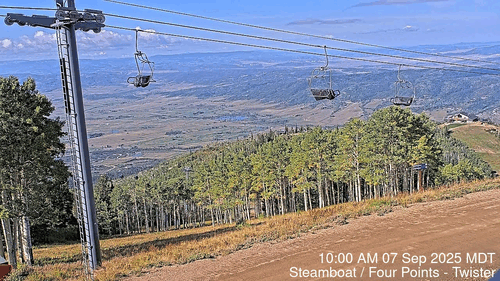 The changing fall colors have migrated to the lowest elevations, and leaves are dropping rapidly. To celebrate this spectacular fall, I have a month-long time-lapse from Steamboat’s Four Points cam starting September 7th that looks down Twister toward the South Valley. The color peaked for the three days starting on September 22 at around 9,700′, right on schedule, progressing downward in elevation before peaking two weeks later at around the 9,080′ level of Thunderhead Lodge. Both September 23, our first snowfall, and September 27 were omitted due to the cloudy conditions.
Now, a ridge of high pressure sits over Texas, an eddy of low pressure lies off the Pacific Northwest coast, and former Hurricane Priscilla is moving northeastward between these features. Enough moisture has made it to our area for a quick shower that just now left a tenth of an inch of rain near the Steamboat Ski Area.
But this is just a prelude; a much stronger push of moisture arrives Friday morning, starting showers before noon that will last through the rest of the day and overnight. Meanwhile, the eddy off the Pacific Northwest will be pushed eastward by a storm moving through Alaska, eventually ingesting some cold from western Canada as the two storms briefly phase by Saturday afternoon.
Showers will continue on Saturday and overnight as some of the Alaska storm is absorbed into the eddy and some moves southward along the West Coast. A cold front is forecast to move through late Saturday night or early Sunday, bringing snow levels down to 8,500′, or possibly 8,000′, though only minor accumulations are expected as the coldest air arrives as the moisture is dwindling.
After high temperatures in the low sixties on Friday and Saturday, right at our average of sixty-two degrees, the showers on Sunday morning should end by the afternoon, with some sun appearing, though high temperatures will be relegated to only the low fifties in the cool post-frontal air mass.
Between the departing storm and the new storm forming along the West Coast, temperatures will rebound to around average to start the work week with a mostly sunny Monday morning. However, uncertainty arises as early as Monday afternoon, as moisture from another tropical system off the coast of Baja may or may not be directed northeastward toward our area by the southwest winds ahead of the new storm and behind the eastward-moving Texas ridge of high pressure.
Let’s hope for the forecast beneficial rainfall, and I’ll have more details on the West Coast storm in my next regularly scheduled weather narrative on Sunday afternoon.
Weather to turn warmer and sunnier through the workweek
Sunday, October 5, 2025
Temperatures are in the cool lower fifties early this Sunday afternoon in Steamboat Springs, on their way to only the mid-fifties, with partly sunny skies behind the cold front on Saturday. Temperatures will warm back towards seventy degrees by midweek, with increasingly sunny skies, before the weather turns unsettled around next weekend.
 The spectacular color show this fall has migrated to the lower elevations, but not before we enjoyed beautiful weather last week to view the spectacle. These two photos highlight some of the color on the Pioneer Trail at the Steamboat Ski Area on Thursday, though yesterday’s storm, which left between two and four-tenths of an inch of rain around town, including some pea-sized hail and brief upper-mountain snowfall when the cold front passed through just after noon, surely would have thinned or removed some of that foliage.
 Similar to yesterday, we have another fifty-degree day today, with more clouds than sun, which is around ten degrees below our average of sixty-five degrees. An approaching ridge of high pressure behind the storm will bring warming temperatures and increasingly sunny skies through the workweek, but not before part of the lingering southern portion of the storm, which has elongated toward the Desert Southwest, reluctantly moves through on Monday.
Temperatures will approach sixty degrees on Monday with more sun than clouds, though a stray shower can’t be ruled out as the storm leftovers pass. Mostly sunny skies with temperatures near average are forecast for Tuesday, rising to near seventy degrees on Wednesday, and the low seventies by Thursday, with continued mostly sunny skies.
Meanwhile, a storm in the Bering Sea is forecast to move across the Gulf of Alaska early in the workweek before elongating along the West Coast midweek, with the southern end of the storm briefly forming an eddy. Additionally, Tropical Storm Priscilla, south of Baja, is forecast to reach hurricane status before weakening and moving northward.
Another pulse of energy is forecast to move across the Gulf of Alaska, forcing the West Coast storm inland around the end of the workweek and towards our area by around next weekend. However, there is uncertainty regarding whether the entire tropical storm will be absorbed, or just some of its moisture, and where in the Great Basin that occurs. While we could see unsettled weather as early as Friday, it may hold off for part of the weekend. Regardless, the storm is cold enough to bring at least some high-elevation snowfall.
So enjoy the pleasant workweek ahead, and I’ll have more details on next weekend’s storm in my next regularly scheduled weather narrative on Thursday afternoon. Additionally, I have been archiving the Steamboat Four Points webcam images for the last month, and hope to have a time-lapse of the changing aspen trees.


