
Spectacular weather to continue this week

Sunday, September 29, 2024
Temperatures are around seventy degrees, again on their way into the low-eighties, under mostly sunny skies this Sunday noon in Steamboat Springs. Despite some cooling starting tomorrow, mostly sunny skies and high temperatures in the mid to upper-seventies will persist through the work week and into the following weekend.

 The 84 F high temperature in town last Wednesday broke the previous record for the date set in 2015 by one degree. Even though the official data are yet to be published by the weather station near the high school, we should be challenging the previous records of 83 F set in 2001 on Friday, 2010 on Saturday and 2019 today.
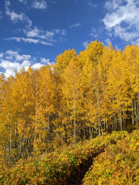
The warm sunny days and clear crisp nights with lows in the mid to upper-thirties and low forties, between five and ten degrees above our average of 31 F, have allowed quite the color spectacle to appear over the area, as shown by some recent photos.
The current weather is due to a ridge of high pressure over most of the West. An eddy of low pressure over central California has pulled a modicum of moisture northward toward our area, while a quick-moving wave of low pressure has moved through Vancouver.
We may see more afternoon clouds today and perhaps even an insignificant afternoon or evening shower ahead of the Vancouver storm which is forecast to sweep across the northern Rockies on Monday.
Ahead of a cool front from the storm tickling our region late Monday or early Tuesday, breezes from the west will pick up later today and especially Monday, perhaps shaking some leaves off the colorful display. High temperatures will drop into the upper-seventies on Monday and the mid-seventies on Tuesday, still well above our average of 68 F.
The grazing cool front will be our only weather this week, with mostly sunny skies and mid-seventy temperatures persisting through the work week and into the weekend. There was a chance for a pattern change around next weekend, but current weather forecast models have the western ridge of high pressure deflecting or weakening any incoming Pacific weather systems.
So enjoy the summery weather ahead, and check my next regularly scheduled weather narrative on Thursday afternoon to see if this gorgeous weather persists through next weekend.
Gorgeous weather to continue through the weekend
Thursday, September 26, 2024
Mostly sunny skies and eighty-one-degree temperatures are over the Steamboat Springs area late this Thursday afternoon. This gorgeous weather will continue through the weekend, leaving a simple and short weather narrative for this afternoon.
A ridge of high pressure is currently over the western two-thirds of the country while rapidly intensifying Hurricane Helene approaches the Big Bend region of Florida. Eventually, the tropical storm will merge with an eddy of low pressure over the Mississippi River Valley, with that interaction lasting through at least the weekend, but that will not affect our weather.
Instead, a quick-moving and dry storm that moved across the northern Rockies today has squashed the northern part of the ridge and carried a modicum of moisture overhead for some sparse clouds today. Another similarly dry but stronger storm is forecast to cross the Pacific Northwest coast on Sunday, keeping the sparse moisture around for some afternoon clouds, but not affecting the mostly sunny skies with high temperatures in the low-eighties. This is over ten degrees above our average of 69 F and might threaten the record temperature of 83 F set in 2001 on Friday, 2010 on Saturday and 2019 on Sunday.
And even though the average low temperature has fallen to freezing, the mild air mass under the ridge of high pressure will moderate low temperatures and keep them in the mid to upper-thirties and low-forties.
The fall colors are nearing a peak above 9000′, if not already there, so get out and enjoy the stellar weekend that will feel more like summer than fall. That Pacific Northwest storm may induce some afternoon breezes from the west as soon as Sunday afternoon ahead of a grazing and dry cold front late Monday or early Tuesday. I’ll have more details about that in my next regularly scheduled weather narrative on Sunday afternoon.
Beautiful early fall weather ahead
Sunday, September 22, 2024
Fall was shepherded into the Steamboat Springs area Saturday afternoon by a blustery storm short on precipitation. Cool and unstable air behind the storm will keep some clouds around for the first day of fall this Sunday with high temperatures in the mid-sixties. Even though Monday will start sunny, we should see afternoon clouds ahead of a grazing cold front early Tuesday that will keep temperatures below seventy degrees. But mostly sunny skies with high temperatures reaching seventy degrees on Tuesday and upper-seventies starting Wednesday promise a beautiful stretch of weather lasting into the weekend.
Hopes for a dusting of snow at the top of the Steamboat Ski Area last night were dashed by a storm that traveled a bit further south than forecast. We were left with gusty winds reaching 43 mph at the Bob Adams airport and 62 mph at the Storm Peak Lab with an easterly component that squashed most precipitation, thanks to downsloping off the Park Range. Most of town received about five-hundredths of an inch of rain, and no precipitation occurred at the top of the ski area in time for the freezing temperatures which arrived just before midnight.
Fortunately, fall color has only started to appear, and most leaves were left on the trees for what promises to be a great show thanks to the rapidly appearing color. We should see a mix of sun and clouds this Sunday with high temperatures in the mid-sixties, about five degrees below our rapidly falling average of 71 F.
A cold front forecast by the European ECMWF to be more impactful in previous model interations will end up only grazing our area early Tuesday morning, similar to the American GFS, bringing some Monday afternoon clouds after a sunny but chilly start. Low temperatures Monday should fall to just below our average of 34 F with high temperatures a few degrees warmer than today.
But a ridge of high pressure is forecast to build over the West behind the grazing front starting Tuesday and lasting into the following weekend. Despite our average high temperatures falling to 69 F by Thursday, mostly sunny skies will allow high temperatures to reach the upper-seventies starting Wednesday and continuing into the weekend.
Low temperatures will also rise, but still remain below forty degrees, leading to quintessential Colorado early fall weather with warm sunny days and crisp cool nights, ideal for both producing and viewing the fall color spectacle.
So enjoy the perfect weather window this week, and check back to my next regularly scheduled weather narrative Thursday afternoon to see if this lasts through next weekend.
Storm to arrive Saturday afternoon
Thursday, September 19, 2024
A beautiful day is over the Steamboat Springs area this Thursday midafternoon with cloudless skies and temperatures in the low seventies, around our average of 73 F. The colors are starting to change, and so is our weather, with another beautiful day Friday followed by a cold front Saturday afternoon. We may see the season’s first snowfall near the top of the Steamboat Ski Resort by Sunday morning, just in time for the Autumnal Equinox, occurring first thing Sunday at 6:43 am.
A storm moving through Vancouver is forecast to nudge an eddy of low pressure off the central California coast eastward through the weekend, first moving across Las Vegas on Friday, the Four Corners on Saturday, and then northeast Colorado on Sunday as it is deflected to the northeast by a ridge of high pressure over Texas. This is slower than even the slowest weather forecast predicted in my last weather narrative, and the timing may still be too fast.
Right now, the Vancouver storm is forecast to drag a cold front through our area Saturday afternoon which will interact with the approaching eddy. Moisture will be drawn northward from the Gulf of Mexico ahead of the eddy and behind the Texas ridge, and eventually wrap over our area by later Saturday. We should start the day sunny, but increasing clouds with gusty easterly winds will interact with the cold front to start showers by the afternoon or evening.
Precipitation should become moderate at times through the night, with snow levels dropping from above 12,000′ before the cold front Saturday morning to below 10,000′ by Sunday morning. We may wake up Sunday morning to the season’s first high-elevation snowfall, though it may be hard to see behind clouds that should clear behind the storm during Sunday. Be sure to check the Steamboat Powdercam on the SnowAlarm home page to see any evidence!
High temperatures will fall into the low sixties on Sunday, and there may be some sunshine along with possible afternoon showers in the unstable air mass, though some weather forecast models are drier than others.
Day length is changing quickly, and we are losing about seven minutes of daylight a week at the start of the day and twelve minutes at the end, so be sure to take advantage of a nice Friday and the first half of Saturday. Another storm is forecast to move through Vancouver late Sunday and possibly affect our weather during the start of the work week, and I’ll have more details about that in my next regularly scheduled weather narrative on Sunday afternoon.
Two storms to affect our weather this week
Sunday, September 15, 2024
After a spectacular couple of sunny days, cloudy skies greeted Steamboat Springs this Sunday with temperatures reaching the low-seventies as of early afternoon. Though the skies look threatening, rainfall will have a hard time reaching the ground today, with a better chance on Monday and good chances on a cool Tuesday ahead of a cold front. High temperatures in the upper sixties will persist for Wednesday and Thursday ahead of another storm for the end of the workweek.
Remnants of Tropical Storm Ileana to our south and an approaching storm over the California and Oregon coasts to our west will dominate our weather through midweek. Moisture from Ileana has been carried over our area by winds from the southwest ahead of the West Coast storm. Another developing storm in the Gulf of Alaska will start forcing the West Coast storm eastward. It is forecast to wobble through the Great Basin on Monday and be deflected to our northeast on Tuesday before reaching Montana on Wednesday and the southern Canadian Plains on Thursday.
High temperatures should be in the low seventies on Monday after a mostly sunny start to the day, near our average of 74 F. Energy ejecting out ahead of the approaching storm will combine with the tropical moisture for afternoon and evening shower chances.
Those chances become likely Tuesday thanks to a lobe of energy rotating around the storm and moving overhead. High temperatures will fall to the mid-sixties, almost ten degrees below average on a breezy, showery day punctuated by a cold front moving through in the afternoon.
Moisture will be swept from our area behind the departing storm for a dry Wednesday and a few degrees of warming. Snow levels will fall to 10,000′ behind the front Tuesday night, and if moisture can hang on there may be some snowflakes at the top of the Steamboat Ski Resort. If skies clear by Wednesday morning, the Yampa Valley could see low temperatures just below freezing, about five degrees below our average of 35 F, especially in the low-lying areas.
Meanwhile, the next storm is forecast to have moved southward along the West Coast, and winds from the southwest ahead of the storm will allow high temperatures to rise toward seventy degrees on a dry Thursday.
There is agreement among the weather forecast model that the next storm will be colder and drier, but disagreement on how quickly the center moves eastward across the Desert Southwest. The American GFS has showers breaking out on Friday ahead of the storm, while the European ECMWF is a half-day behind. If we don’t see a dusting of snow on Mt. Werner on Wednesday morning, the first high-elevation snowfall of the season may be visible by Saturday morning.
Enjoy the last full week of the summer season as the Autumnal Equinox occurs next Sunday at 6:43 am, and check back to my next regularly scheduled weather narrative on Thursday afternoon for more details on the developing next storm.


