
Snows continue through Monday night ahead of warming and drying
Sunday, January 6, 2019
Light snows that started around sunrise in the Steamboat Springs area this Sunday morning are expected to be showery early this afternoon and increase ahead of a short break after midnight before picking up again after sunrise Monday. Clearing starts on Tuesday, with warmer and dry conditions now forecast through at least part of next weekend.
The current storm affecting the west left impressive amounts of snow in the Sierras so far, with 19” reported this morning at Squaw / Alpine Meadows and lots more expected. For our area, light snow will pick up this afternoon ahead of a weak cool front expected to pass through northern Colorado early this evening. Southwest winds aloft will turn westerly when the front passes, with snows becoming moderate for a time, before temporarily ending around midnight.
I would expect 5-10” of snow to be reported at mid-mountain at the Steamboat Ski Area for the Monday morning report, before they pick up again during the day as another storm with stronger westerly winds but less moisture moves across our area. Those that ski Steamboat know that westerly winds can adversely affect snow quality as much of the mountain faces west, and this may be the case during the day with increasing westerly winds, though there may be a slight turn to the west-northwest by Monday night.
With snow showers possibly hanging on through early Tuesday morning, we could see another 2-5” by the morning report. Thankfully, winds will decrease as a ridge of high pressure moves across the west, first bringing clearing behind the storm for Tuesday and warming for Wednesday, along with plenty of sun.
The storm for the end of the work week in the previous forecast discussion has mostly disappeared from the weather forecast models, with the once strong Gulf of Alaska storm expected to weaken and split as it approaches the West Coast on Wednesday, The northern part of the split may bring some clouds and a slight cooldown on Thursday as it is forced to our north by the ridge of high pressure over most of the west, but precipitation is no longer expected.
Friday and Saturday look dry, though another storm which has very little moisture rides over the top of the western ridge of high pressure and grazes our area on Saturday. The eventual strength and position of the western ridge will determine how much cooling we see early in the weekend.
Another couple of Pacific storm approach the West Coast early and late in the weekend. While the first once looks to also strongly split as it crosses the coast, there may be enough moisture that penetrates inland to bring clouds to our area late in the weekend. The second storm is looking more promising for early in the next workweek, though considerable uncertainty exists this far out in the forecast as the American GFS is far more enthused about the storm than the European ECMWF.
I absolutely love this super-warm split-finger mitten-glove! I’m on my second season with these and am very impressed with their durability and warmth, especially when combined with the standard HotHands handwamers. Three fingers sit together with the index finger separated, but there is enough room to scrunch all your fingers together while on the lift, which is especially nice if you have a handwarmer in the mitten-part of the glove.
Three day time series of SNOTEL temperatures at Buffalo Pass and Rabbit Ears Pass added!
Friday, January 4, 2019
I am now decoding the SNOTEL (snow telemetry) sites for Buffalo Pass (elevation 10.500′) and Rabbit Ears Pass (elevation 9,400′) and presenting them as a three day timerseries. This provides another source of temperature data at elevations similar to the top of Mt. Werner and mid-mountain, respectively.
 They are available on the home page, with more details about three day timeseries here.
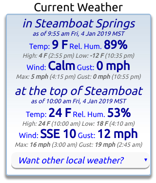
Also note that I am now displaying the current summit temperatures and winds for the Steamboat Ski Area and the town of Steamboat Springs (from the Bob Adams airport) at the top of the home page (along with a daily summary of the high and low temperatures and maximum wind speed and gust and time of occurrence) for quick reference. I always check these data before heading out on the hill.
I am considering the addition of other locations; please email me your favorite locations and I’ll try and find a station nearby.
Finally, note that you can access all timeseries from the Want other local weather? pulldown, which is also located under the Local Temperatures, Winds & Precipitation heading
Warming ahead of our next Monday powder day
Thursday, January 3, 2019
Though the Steamboat Springs area is enjoying its third cloudless day since the arctic intrusion on Monday, cold temperatures persist in the Yampa Valley as a stout temperature inversion has formed, where air is warmer at higher elevations. In fact, as of 12:45 pm today, the temperature at the base of the Steamboat Ski Area is 12 F while the mid-mountain temperature is 27 F.
Temperatures will continue to warm through Saturday along with mostly sunny skies, albeit more slowly at lower elevations, as a ridge of high pressure moves over the west. However, the ridge will keep moving eastward as our next Pacific storm begins affecting the West Coast on Saturday and our area on Sunday.
This next storm is interesting since it looks to mix with some subtropical moisture that is forced northward by a piece of our very cold New Year’s Day storm that was left behind over the central Pacific before sinking southward into the subtropics. This piece of the storm looks to linger down there, perhaps providing a source of moisture for additional upcoming storms.
But in the near term, the Pacific storm will spread moisture into our area on Sunday, likely starting snow showers by the afternoon. Snows should pick up later in the day and overnight as a cool front passes through the area before decreasing Monday morning.
There is a fair bit of uncertainty for snow amounts as dry air from the west-southwest behind the Pacific storm is forecast to sever the moisture tap over our area by Sunday night, and models disagree on the positioning and timing of this dry air intrusion. Furthermore, it appears the storm will weakly split for a time around Sunday night, further complicating the forecast. Right now, I would guess 5-10” for the Monday morning report.
West-northwest winds pick up behind the front by Monday morning, keeping light snows going through the day and possibly through the night along with windy conditions, with another 1-4” possible that would be reported Tuesday morning.
A ridge of high pressure is advertised to move over our area for Tuesday and Wednesday before the next Pacific storm is advertised for Thursday. This one currently looks to again mix with moisture from the subtropics as a piece of the old New Year’s Day storm continues to linger down there, so there is a possibility of another significant storm.
Stop battling cold feet! I’ve used the awesome Hotronic foot warmers from their beginnings, and can honestly say that each iteration of the product is better than the last. I have the S4 custom, attached to my powerstrap so they never fall off, and my toes stay warm for my entire ski day.


