
Update to the Wednesday storm
Tuesday, January 15, 2019
A quick update this Tuesday morning to increase my expected snowfall for the storm tomorrow. Soon after publishing my Sunday forecast, weather forecast models trended stronger and wetter with the storm. Clouds have already overspread the Steamboat Springs area, and light snow should get started around midnight tonight.
I still expect 1-4” by the Wednesday morning report, but the stronger storm means a stronger push of cool air around noon as the cold front passes, and better northwest flow behind the front that will continue snows through the evening.
Though I hate changing a forecast, mainly because I am exposed to being wrong twice, I now expect 3-6” during the day Wednesday with an additional 1-4” after the lifts close. Even after the front passes, temperatures will not be that cold and the snow will be fairly dense, which should provide a nice cushion for some good skiing by the afternoon.
The next quickly-following storm for later Thursday through Saturday morning is still on track to deliver significant snowfall, along with difficult travel conditions, and I plan to write about that more in my usual Thursday weather narrative.
Significant end of workweek storm possible
Sunday, January 13, 2019
The Steamboat Springs area is enjoying a beautiful crisp winter morning this Sunday as a decaying storm drifts eastward across our southern border. The weather will turn unsettled by midweek with a significant storm looking more and more likely for the end of the work week.
After a cool start this Sunday due to a strong temperature inversion in the Yampa Valley, temperatures will have a hard time reaching our average high of 27 F today. Under the clear skies forecast for tonight, Monday will again start out chilly as the temperature inversion persists, with low temperatures below our average low of 3 F and high temperatures once again struggling to reach our average.
Meanwhile a Pacific storm approaches the West Coast later Monday with most of the energy forecast to be shunted to our northwest as it battles a ridge of high pressure over the northern Rockies. However, some moisture and energy do make it far enough inland to bring increasing clouds to our area around midday Tuesday. Light snow showers are advertised from about Tuesday evening through Wednesday, with 1-4” inches expected by Wednesday morning and another 1-4” falling during the day for the Thursday morning report. While I don’t expect to see 8” over the two days, the uncertain start and end of this small storm makes timing the amounts difficult.
Another colder and much stronger Pacific Storm crosses the West Coast midweek, and we may see some brief ridging ahead of that storm on Thursday before significant energy and moisture begin moving over our area in the afternoon or evening in favorable northwest flow.
If the current forecast holds, moderate to heavy snows are likely from Thursday night through Friday as two waves of energy and moisture pass over our area, with lighter snows continuing into Saturday behind the strongest part of the storm. Snowfall is likely to be at least 6-12” from Thursday night through early Saturday, with as much as twice that possible.
A ridge of high pressure is then forecast to build over the West behind the departing storm and ahead of another strong Pacific storm. This one is forecast to cross the Pacific Northwest Coast mid-weekend and mix with some very cold air from western Canada as it approaches our area, bringing the possibility of more significant snowfall early in the next work week.
Stop battling cold feet! I’ve used the awesome Hotronic foot warmers from their beginnings, and can honestly say that each iteration of the product is better than the last. I have the S4 custom, attached to my powerstrap so they never fall off, and my toes stay warm for my entire ski day.
I also use a boot dryer/warmer after every ski day, and the Happy Feet Dry-n-Warm boot dryer would be my choice if I ever had to replace my 30 year old and no-longer-manufactured look-alike. Just insert into your ski boots at the end of the day and leave them plugged in overnight. They become only slightly warmer than your body temperature so are safe to be plugged in for all footwear for days on end, though only overnight is needed for even the soggiest of liners. The ski boots are then thoroughly dry and toasty warm to start your next ski day!
Quiet weather follows some light snow for Friday
Thursday, January 10, 2019
A Pacific storm currently crossing the Great Basin will bring some light snows to the Steamboat Springs area on Friday. Quiet weather is then expected until midweek when another round of incoming Pacific energy brings snow chances back to the west.
The current partly sunny conditions this Thursday morning will give way to clouds later today and snow showers after midnight as a Pacific storm crosses the Great Basin. The storm will undergo a modest split as it passes over Colorado, with the best precipitation expected to our south and east as it mixes with some cool air from the Canadian Plains. We may see an inch for the Friday morning ski report and possibly several more inches during the day before showers end Friday night.
A rather convoluted weather pattern then ensues over the west as a ridge of high pressure tries to build ahead of another Pacific storm that crosses the West Coast on Saturday. However, the southern part of the ridge quickly succumbs to the Pacific storm as it races across the Desert Southwest through the rest of the weekend, leaving north-central Colorado caught between the building ridge of high pressure to our north and the storm to our south.
The end result for our area should be decreasing clouds on Saturday and seasonably cool temperatures with mostly calm conditions. This weather will persist through the first half of the work week ahead another Pacific storm that begins affecting the West Coast late in the weekend. Most of the energy will be dissipated and shunted north as it battles the ridge of high pressure over the Intermountain West; in fact northern portion of the ridge amplifies ahead of the storm and eventually treks across Alaska and the Bering Sea. This may be important for our area later in the month as chunk of very cold air is forced southward over Japan and fuels a series of storms that may move across the Pacific and eventually impact our continent.
In any event, we may see some increasing clouds by later Tuesday and some snow showers on Wednesday and Thursday as some of the energy and moisture from the Pacific storm survives the battle with the ridge and moves over our area.
A more active pattern is advertised for around the following weekend or soon thereafter as the hemispheric jet stream reorganizes, though there are significant differences in timing, strength and position of storms between the weather forecast models.
Save your soles! You suspect that the grating and grinding sounds you hear from your ski boots as you walk across hard surfaces can’t be good. In fact, worn boot soles make your binding unsafe as it interferes with the boot-binding interface. Cat Tracks are a flexible protector that keeps your boot soles pristine, and adds a cushion for walking comfort. When it’s time to click into bindings, I take them off and stash them in my coat pocket. Yaktrax
are similar, but I have not used them since they appear they would take up a bit more space in my jacket pocket. But you get a rocker sole that promotes a natural stride which may be worth the space sacrifice. If I did not have to carry them around all day, these would be my choice.
Snows continue through Monday night ahead of warming and drying
Sunday, January 6, 2019
Light snows that started around sunrise in the Steamboat Springs area this Sunday morning are expected to be showery early this afternoon and increase ahead of a short break after midnight before picking up again after sunrise Monday. Clearing starts on Tuesday, with warmer and dry conditions now forecast through at least part of next weekend.
The current storm affecting the west left impressive amounts of snow in the Sierras so far, with 19” reported this morning at Squaw / Alpine Meadows and lots more expected. For our area, light snow will pick up this afternoon ahead of a weak cool front expected to pass through northern Colorado early this evening. Southwest winds aloft will turn westerly when the front passes, with snows becoming moderate for a time, before temporarily ending around midnight.
I would expect 5-10” of snow to be reported at mid-mountain at the Steamboat Ski Area for the Monday morning report, before they pick up again during the day as another storm with stronger westerly winds but less moisture moves across our area. Those that ski Steamboat know that westerly winds can adversely affect snow quality as much of the mountain faces west, and this may be the case during the day with increasing westerly winds, though there may be a slight turn to the west-northwest by Monday night.
With snow showers possibly hanging on through early Tuesday morning, we could see another 2-5” by the morning report. Thankfully, winds will decrease as a ridge of high pressure moves across the west, first bringing clearing behind the storm for Tuesday and warming for Wednesday, along with plenty of sun.
The storm for the end of the work week in the previous forecast discussion has mostly disappeared from the weather forecast models, with the once strong Gulf of Alaska storm expected to weaken and split as it approaches the West Coast on Wednesday, The northern part of the split may bring some clouds and a slight cooldown on Thursday as it is forced to our north by the ridge of high pressure over most of the west, but precipitation is no longer expected.
Friday and Saturday look dry, though another storm which has very little moisture rides over the top of the western ridge of high pressure and grazes our area on Saturday. The eventual strength and position of the western ridge will determine how much cooling we see early in the weekend.
Another couple of Pacific storm approach the West Coast early and late in the weekend. While the first once looks to also strongly split as it crosses the coast, there may be enough moisture that penetrates inland to bring clouds to our area late in the weekend. The second storm is looking more promising for early in the next workweek, though considerable uncertainty exists this far out in the forecast as the American GFS is far more enthused about the storm than the European ECMWF.
I absolutely love this super-warm split-finger mitten-glove! I’m on my second season with these and am very impressed with their durability and warmth, especially when combined with the standard HotHands handwamers. Three fingers sit together with the index finger separated, but there is enough room to scrunch all your fingers together while on the lift, which is especially nice if you have a handwarmer in the mitten-part of the glove.
Three day time series of SNOTEL temperatures at Buffalo Pass and Rabbit Ears Pass added!
Friday, January 4, 2019
I am now decoding the SNOTEL (snow telemetry) sites for Buffalo Pass (elevation 10.500′) and Rabbit Ears Pass (elevation 9,400′) and presenting them as a three day timerseries. This provides another source of temperature data at elevations similar to the top of Mt. Werner and mid-mountain, respectively.
 They are available on the home page, with more details about three day timeseries here.
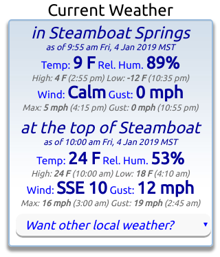
Also note that I am now displaying the current summit temperatures and winds for the Steamboat Ski Area and the town of Steamboat Springs (from the Bob Adams airport) at the top of the home page (along with a daily summary of the high and low temperatures and maximum wind speed and gust and time of occurrence) for quick reference. I always check these data before heading out on the hill.
I am considering the addition of other locations; please email me your favorite locations and I’ll try and find a station nearby.
Finally, note that you can access all timeseries from the Want other local weather? pulldown, which is also located under the Local Temperatures, Winds & Precipitation heading


