Friday night rain turns to Saturday snow ahead of a warm and dry work week
Friday, February 10, 2017
A splitting wave is currently crossing the West Coast and will affect our weather this weekend. The southern portion of the split will form a closed low and dive south to Baja by Sunday as the northern portion of the split screams across the northern U.S. this weekend as an open wave.
Before the Steamboat Springs area feels the effects from the northern part of the storm, energy ejecting out of the southern part of the storm will bring rain showers to elevations below around 9000′ by this evening.
The precipitation will increase in intensity overnight as temperatures begin to cool due to the approach of the northern portion of the storm. Snow levels will drop overnight and into tomorrow morning before the Yampa Valley sees snow, but the timing of that switch is uncertain. Models have trended a bit faster with the arrival of cool air, and current forecasts have the switch to snow occurring early Saturday morning for the valley.
Temperatures will continue to cool through Sunday morning as the northern portion of the storm moves east of our area, but snows should end by later Saturday as moisture quickly erodes behind the diffuse cool front. Snow forecasts for the hill are tough due to the timing of the switch and the temperature-related density of snow, but right now I expect 3-6” of dense snow for the morning report and and additional 3-6” of lighter and fluffier snow during the day Saturday, most of which will occur before noon.
While the main part of this storm ends later Saturday, and some dry air works into northern Colorado by early Sunday, moisture from the Baja low is forecast to move northward and bring some clouds with the chance of light showers later Sunday as it combines with some left-over energy from the northern part of the storm.
Meanwhile, the Bering Sea ridge present these last few weeks is forecast to collapse, allowing cold air from Siberia and the North Pole to surge into the central Pacific. Initially, a ridge of high pressure will build off the West Coast as the Pacific jet stream is re-energized. This ridge is forecast to translate over the western U.S. during the work week, bringing warm and mostly sunny conditions. However, the re-energized Pacific jet will likely bring more stormy weather sometime around President’s Day weekend or soon thereafter.
The storm that stayed away
Thursday, February 9, 2017
It’s hard to believe that we received so little snowfall from this storm, especially since all guidance pointed to significant accumulations.
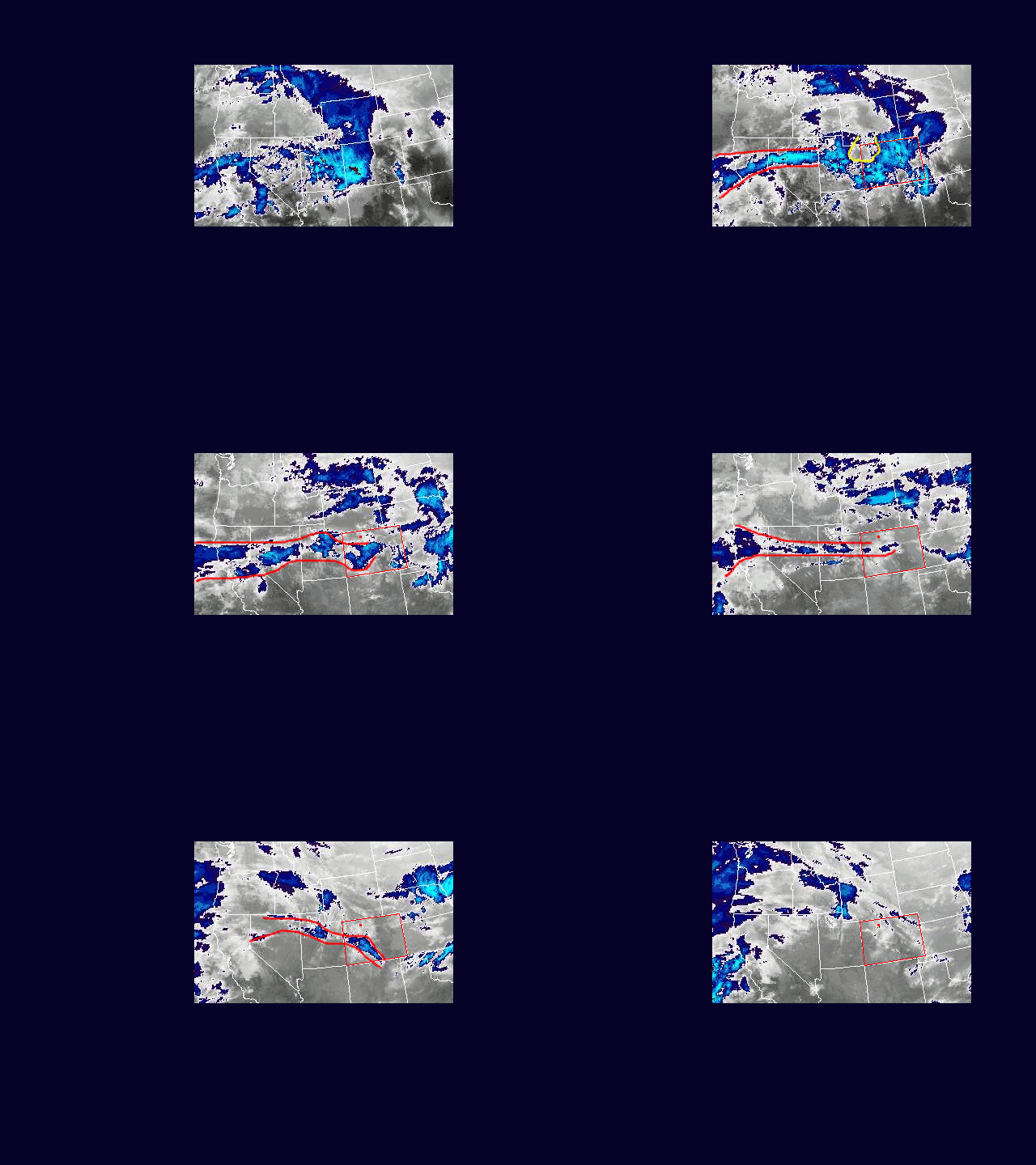
I’ve prepared a loop of the Western U.S. IR satellite from 1pm Tuesday, 7 Feb 2016 MST through 7am Wed when numerical models indicated the Steamboat Springs area would have the heaviest snowfall. Colorado is outlined in red, and there is a red dot in northwest Colorado that represents the location of Steamboat Springs. My 6-12” forecast was woefully wrong as we only received about 2” during the afternoon on Tuesday and some rain early Wednesday morning.
I’ve annotated some of the images in the loop to roughly outline the Pineapple Express snaking through the Great Basin. I’ve also highlighted a large dry area that appeared later Tuesday in yellow.
Rather than Pineapple Express, meteorologists have started calling these wet events with a tropical and/or subtropical connection Atmospheric Rivers, as that descriptive term better captures the sometimes thin and wavy moisture feed.
Two features that likely doomed snowfall for the Steamboat Springs area were the large dry area highlighted in yellow that moved over our area late Tuesday afternoon, and the thinning Atmospheric River of moisture that passed just south of us Tuesday evening. The southern movement of the Atmospheric River was due to the passage of a correctly forecast weak cool front. There were periodic enhancements along the I-70 corridor that contributed to some 10” reports as the Atmospheric River moved south, but the big winner was Monarch that reported 17” and was the result of the Atmospheric River loitering over that area before it became diffuse and moved back north as a warm front overnight. The passage of this warm front brought the rain and gusty winds observed very early Wednesday morning.
But still, how could the models have gotten it so wrong? This Atmospheric River event was relatively narrow in width and I believe that made it’s measurement problematic. Upper air moisture is measured by balloons released every 12 hours, but their locations are several hundred miles apart or more. It becomes difficult to accurately measure and resolve a narrow band of moisture, and all of the numerical models were initialized with a broader extent of moisture than was actually present.
The result was that snowfall produced under the Atmospheric River was narrower and spottier in areal extent than forecast. This was exacerbated by the narrowing of the Atmospheric River in the latter half of the storm.
Early and late-week storms on tap
Sunday, February 5, 2017
The re-emergence of a strong Bering Sea ridge, which was observed earlier this winter season, has directed cool air from Siberia and the North Pole southward into the Gulf of Alaska while also routing moist Pacific energy underneath in another incarnation of the Pineapple Express.
A complicated weather forecast ensues as the warm Pacific airmass battles the cold northern-latitude airmass for about the next week. Models have trended toward a more diffuse solution with less cold air for the Steamboat Springs area, bringing snow showers to the hill and a rain/snow mix to the valley by Monday afternoon.
Mainly light precipitation should turn to all snow and continue overnight, leaving 1-4” on the Tuesday morning report until a cool front passes on Tuesday, increasing snowfall rates and decreasing snow densities during the day Tuesday in breezy west to northwest flow. Temperatures warm again later Tuesday into early Wednesday ahead of another wave of energy that will graze our area during the day Wednesday, again increasing snowfall rates under continued breezy conditions.
Snowfall estimates for the hill are tough due to the varying temperatures and it’s affect on the snow density, but I would expect 6-12” of snow by Wednesday morning and another 2-5” during the day that will be reported Thursday morning.
Currently, Thursday looks like a precipitation-free day with some clouds, before another warm Pacific storm spreads showers over our area around Friday ahead of the Steamboat Springs Winter Carnival weekend. Temperatures will be even warmer, with rain likely in the valley and snow showers above mid-mountain during the day Friday before cooler air arrives by nightfall, turning the rain to snow.
Significant accumulations are expected by Saturday morning before cooler and drier air ends the snows by later Saturday. There is some trailing energy that gets left behind in the southwestern US for Sunday, and our weather may or may not be affected by that late in the weekend or early next week before a western ridge is advertised to bring warming and drying to the area for most of the following work week.
Intermittent snows until stronger and longer-lasting storm next week
Thursday, February 2, 2017
A very complicated weather pattern has developed off the West Coast as the Bering Sea ridge, which was observed earlier in the season, directs cold air from Siberia and western Canada into the Gulf of Alaska as Pacific energy is routed underneath. The end result will be a week of snowfall, with 3-6” of new snow for the Friday morning report, 1-4” for each of the weekend morning reports and likely significant accumulations for a couple of days next week.
Some of the cold air from Siberia and western Canada has mixed with a strong storm between Hawaii and the U.S. mainland and is bringing more heavy precipitation to the Sierra Nevada coastal mountain range. Some energy has ejected out ahead of this storm and has mixed with more cool air from western Canada, bringing the currently observed snowfall to the Steamboat Springs area. Short-range models have increased snowfall from this system, bringing moderate to sometimes heavy showers from this afternoon through the evening before tapering off around midnight and leaving 3-6” for the Friday morning report.
Additional energy and cold air dropping into the Gulf of Alaska on Friday will not only force this weakening storm eastward across the Great Basin, affecting our area Friday night into Saturday, but form a new and stronger storm off the West Coast as it phases with a separate storm undercutting the Bering Sea ridge.
The Friday-Saturday storm is a bit of a wild-card due to its weakening nature, but 1-4” are possible overnight Friday for the Saturday morning report with another 1-4” during the day, to be reported on the Sunday morning report.
Sunday looks to be precipitation-free but likely not cloud-free as moisture lingers in the still moist westerly flow.
Pacific energy undercutting the Bering Sea ridge is forecast to strengthen early in the work week and carry the new storm eastward. Waves of energy in the Pacific jet will interact with cool air moving southward from western Canada, likely bringing a long-duration snow event to Colorado starting later Monday.
Right now, models have the heaviest snows Monday night and again during the day Wednesday, with significant accumulations likely during each period, though the details are almost certain to change as we get closer to next week. Nicer weather is advertised to return near the end of the work week as a West Coast ridge translates over the area.


