
Cold and snowy week ahead
Friday, November 25, 2016
A building ridge brings dry air, sunny conditions and warming temperatures to the Steamboat Springs area today and Saturday. Valleys will start out cold in the mornings due to the formation of temperature inversions encouraged by the the season’s low sun angle and snowfall on the ground.
Three waves of energy will bring cold and snow for Sunday through overnight Tuesday. The first wave will cross the southern California coast Saturday afternoon. Concurrently, the second wave will be forced southward along the West Coast from the Gulf of Alaska by an approaching third wave that will also move through the Gulf of Alaska.
Snows should start by Sunday morning as the first wave is forced northeastward across the Great Basin Saturday night and over our area on Sunday by the second wave. Temperatures look cold enough for an all-snow event as the first storm forms a closed low near the Wyoming - Nebraska border by Sunday night. There may be a burst of snow with the front followed by light to moderate snows in the cool, moist and unstable northwest flow on the backside of the closed low to our northeast that makes travel difficult later in the day. Snows are expected to continue through the overnight Sunday hours, and though amounts are uncertain due to the complicated nature of the storms, we could see 5-10” on the hill by Monday morning.
While the bulk of the second wave dives towards the New Mexico - Mexico border by Monday, some energy does travel over the Rocky Mountains and phases with additional energy traveling around the closed low which is forecast to be around Minnesota by then. I would expect light snowfall for most of the day Monday with occasional heavier showers as lobes of energy from both the northern and southern systems travel over the area. Another 3-6” of snow by Tuesday morning is possible.
The third wave brings much colder air and takes a more inland route, diving southeastward across the Great Basin on Monday. We will see the cold air from this wave starting on Tuesday and accompanied by light low-density snowfall that will last into Wednesday morning. This could leave another 1-4” for the Wednesday morning mid-mountain report.
While Wednesday will start quite cold, we will be in-between systems before another wave from the northwest is forecast by the American GFS to bring light snow showers to our area as soon as Thursday morning. This wave is forecast to split around Colorado minimizing the amount of snow but keeping the unsettled and cool meteorological conditions around through the end of the work week.
Snows for Tuesday, Thursday and Sunday
Monday, November 21, 2016
A warm southwest flow ahead of the next storm brought a quick round of showers early this morning and is expected to do the same around sunset. There was some thunder associated with the storm earlier today down south and that threat will be present for the rest of the day as the bands of precipitation move northward.
But it appears the bulk of the warm precipitation will stay to our south and west until cooler air courtesy of the loosely connected northern portion of the storm moves through our area tonight and winds veer to our favored northwest direction. There is some uncertainty as the bands of heaviest precipitation are forecast to be close, and if they track a but further east than currently predicted, we may receive periods of moderate to heavy precipitation with dense snow at the higher elevations around midnight.
Regardless, behind these bands, we will likely see light to moderate snowfall down to the base with the cooler northwest flow around the several hours before and after sunrise before the snows turn more showery during the day Tuesday and end in the late afternoon or evening.
Snowfall amounts may be in the 4-8” range by Tuesday afternoon with the higher totals at the higher elevations due to the colder temperatures.
A transient ridge is forecast for Wednesday bringing a nice mostly sunny and warm Opening Day with fresh snow.
A quick-moving wave with colder air than the Tuesday storm passes over northern Colorado Wednesday night, and models have trended a bit stronger with more generous precipitation. We could see 3-6” of snow between midnight on Wednesday and noon on Thanksgiving Day before a building ridge brings dry air, sunny conditions and warming temperatures for Friday and Saturday.
Models now have another moderate storm for Sunday, a brief break on Monday and are advertising a much larger and more impressive storm for early in the next work week.
Stellar weekend followed by storm in time for Opening Day
Friday, November 18, 2016
Dry air has invaded the Steamboat Springs area behind the storm that left 13” at the summit. Fresh snow cover and clear skies tonight will make Saturday morning the coldest of the season so far.
Temperatures in the mountains will warm the fastest on a mostly sunny Saturday as a large transient ridge builds over the West, with valleys a bit slower to warm as temperature inversions start to develop.
The ridge looks to persist through at least the rest of the weekend keeping the beautiful weather around until Monday when an incoming Pacific energy weakly splits as it crosses the West Coast. The dominant southern part of the storm draws subtropical moisture over the Great Basin in warm southwest flow and introduces the chance of showers on Monday.
Though the showers will start out warm, with rain possible in the valley, cooler air filters in by sunset Monday courtesy of the northern portion of the storm and will likely turn the rain to snow. Fortuitously, it appears that most of the precipitation will occur after sunset Monday, keeping the bulk of the storm as snow.
Current forecasts have bands of the heaviest precipitation overnight Monday into Tuesday morning before the snow turns more showery during the day Tuesday in the cool, moist and unstable northwest flow behind the storm. The amount of snow in the first part of the storm will be dependent upon where the bands set up, with moderate to sometimes heavy snow showers continuing in the second part of the storm through sunset Tuesday. Amounts are uncertain due to the banding nature of precipitation during the first part of the storm, but 6-12” of snow, starting out dense, but becoming lighter, is possible. Generally, the snow will be quite a bit denser than this past storm as temperatures will be warmer.
A transient ridge is forecast for Wednesday bringing a nice mostly sunny and warm Opening Day with fresh snow.
A minor wave quickly passes over the area late Wednesday or early Thanksgiving Day, possibly bringing some high elevation snow showers before dry air brings back sunny conditions for later in the day and Friday.
Earlier model runs had indicated a possible storm for Saturday, but they have trended weaker and now minimize the chance of precipitation for at least the first part of the weekend.
Winter weather stays on track for Thursday
Monday, November 14, 2016
A building ridge over the Intermountain West will be pushed eastward Tuesday and Wednesday ahead of the well advertised winter-like storm for Thursday. Tuesday will be another warm and sunny day before high level clouds appear on a still-warm Wednesday as breezy to windy southwesterly winds picks up ahead of the strong storm forecast to cross the central California coast Wednesday evening.
Even though there have been vacillations in the model forecast over the weekend, the storm looks to develop largely inline with last Thursday’s forecast. Models still have the storm racing across the Great Basin later Wednesday night before precipitation begins in the Steamboat Springs as early as Thursday morning. If it starts as rain in the valley, it should quickly transition to snow during the day as a strong cold front barrels through the region.
Snows will turn more showery behind the front, but I still expect accumulations Thursday night into Friday as we do well in the cold, moist and unstable northwest flow behind the storm that will leave daytime highs 20F to 30F lower than what we recently have been experiencing. By the time the showers end Friday afternoon or evening, the valley could see 2-5” of snow on unpaved surfaces with 6-12” on the hill.
Dry air is expected behind the storm, likely making Saturday morning the coldest of the season so far if the clouds clear by sunrise. Temperatures in the mountains will warm the fastest on a mostly sunny Saturday as a large transient ridge builds over the West, with valleys a bit slower to warm as temperature inversions start to develop.
The ridge looks to persist through at least the rest of the weekend keeping the beautiful weather around until Monday afternoon when upstream Pacific energy flattens the ridge and reintroduces moisture into the area.
Some moose, fall color and sunsets from the past month
Saturday, November 12, 2016
 Continued warm and sunny days have allowed for a great fall mountain season that looks to continue for several more days until winter arrives about a week before the Steamboat Ski area official opening.
The moose are also out on the trails enjoying the beautiful weather. The picture of the one on the right was taken yesterday on 11 Nov on the Creekside trail right below the Pioneer merge.
The picture of the two moose below was taken on 9 Oct as they rested on lower Tenderfoot. They weren’t moving and they weren’t looking like they would be moving, so I backtracked to find a detour around the family.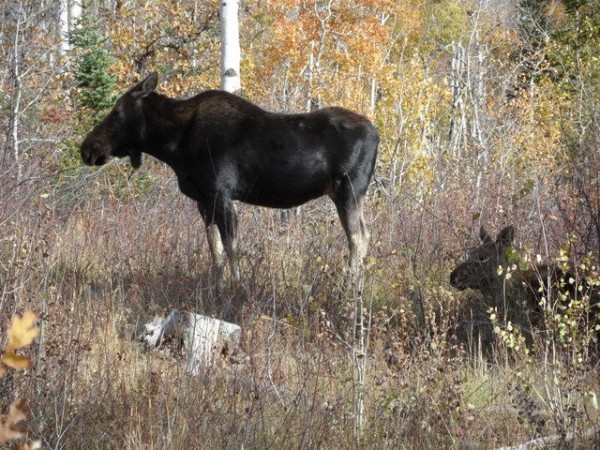
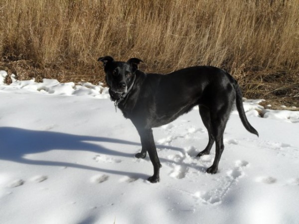 On the way up Zig Zag yesterday, Milly surveyed the latest efforts by the Steamboat Ski area’s excellent snowmaking crew. There were some isolated islands of snow she could roll around on, but winter will have to wait for a few more days.
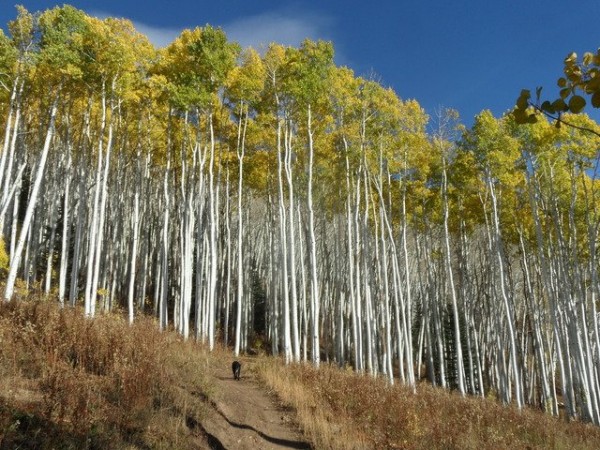
 After seeing the first moose in the pictures above, I headed up Pioneer on my way to Rainbow Saddle and then the gondola. The next 3 photos are all taken in a very similar spot a bit before the uphill trail crosses the Pony Express lifline. That there are no leaves on the trees on 11 Nov is not surprising, but the speed at which the color changed and the leaves dropped was, as shown by the next 2 photos taken less than a week apart, on 15 Oct and 9 Oct.
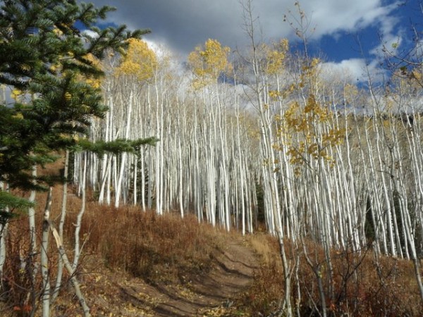
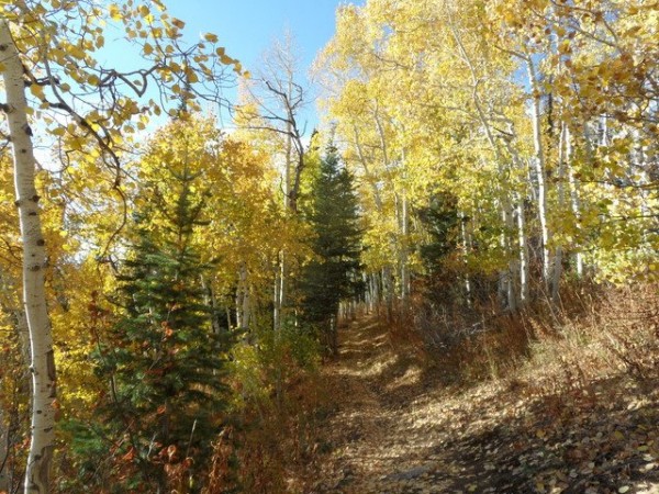 Also on 9 Oct, the photo on the right was taken on the Elkhead trail.
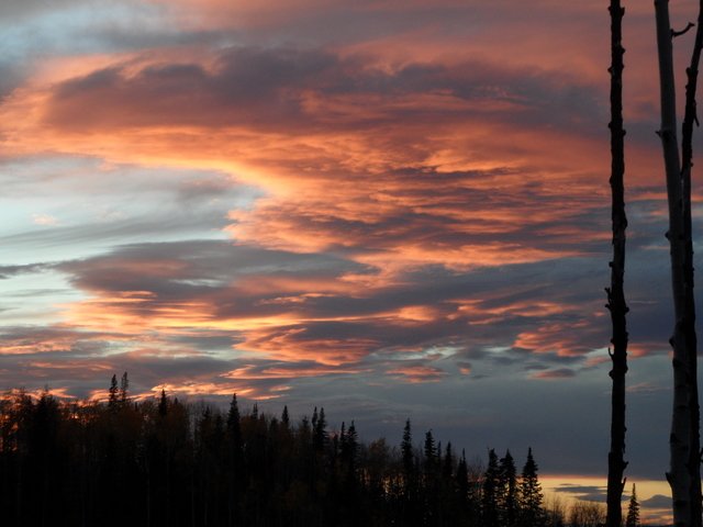
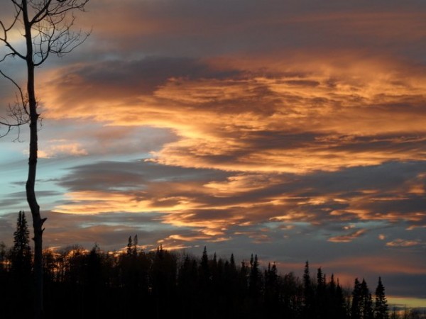 I just can’t resist documenting a nice sunset; the first two were taken on 14 October from the top of Creekside looking south across the Yampa Valley.
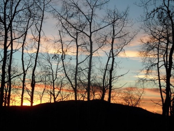 This last photo was taken the next day on 15 October further down the mountain on Gunsmoke.


