Warming and drying starts Thursday
Tuesday, April 29, 2014
An additional 4” has fallen since yesterday afternoon at the top of the Steamboat ski area leading to a storm total of about 9”. The higher elevations of the central Rockies did best as Loveland reported 2 feet in the last 3 days!
Showers should continue today and last through tomorrow as additional waves of energy and cool air rotate around the west flank of the Hudson Bay vortex. In the last blog post, model forecasts had this continuing through the workweek but it now appears the ridge will build eastward enough to keep most of this energy just to our north and east. The end result is drying and and warming temperatures for Thursday and Friday, though Friday may be a bit cooler as models keep the cool air lurking just to our north.
Another Pacific storm forecast to make landfall in the northwest early in the weekend forces this ridge to amplify over our area. Dry air and likely unseasonably warm temperatures will make for a beautiful weekend that will likely persist for Monday as well.
However, the interaction between this Pacific storm and the Hudson Bay vortex still looks to occur beginning over the weekend and will strengthen the storm, bringing showers into our area sometime on Tuesday in increasing southwest flow. The American GFS model advertises another active period of weather starting midweek as the storm moves over our area and lasting through the following weekend, though the European ECMWF has a less amplified and quieter solution.
Unsettled weather continues this week and likely next week as well
Sunday, April 27, 2014
The Steamboat powdercam is showing about 5.5” up top this afternoon with a temperature of 19F, though I had only trace amounts of snow on my deck this morning as the precipitation fell mostly as rain last night. Even though this impressive spring storm is east of us, we will continue to be affected by this storm this entire week as its eastward motion is impeded by additional waves of energy and cold air from the persistent Hudson Bay vortex digging into its western flank. Indeed, the eastern two thirds of the country will soon be affected by this enormous storm.
For our area, a trailing wave from the Pacific northwest will bring another round of showers and cooler temperatures during the day tomorrow and tomorrow night. Snows will continue to accumulate at higher elevations on the hill though the valley precipitation will be either rain or non-accumulating snowfall.
Showers lessen on Tuesday, though they don’t end, and will pick up again Wednesday as a wave rotating around the west side of the Hudson Bay vortex brings another round of cool air and showers. Earlier model runs had the west coast ridge building over us by Wednesday, but the cold air moving southward from Canada will prevent this from happening. In fact, further surges of cold air are now advertised for Thursday and Friday as well, keeping the west coast ridge to our west and showers over our area.
Concurrently, a Pacific storm approaches the coast around the end of the workweek, interacting with and destroying the west coast ridge. There is model uncertainty during the weekend with regards to how much interaction there is between this Pacific storm and energy along the western flank of the Hudson Bay vortex, though both the American and European model keep unsettled weather over our area. The European ECMWF model has more cool air entering the Pacific storm, which may allow temperatures to warm briefly ahead of the storm during next weekend, while the American GFS keeps this storm weaker, but forecasts cool and unsettled conditions in the moist northwest flow through the weekend.
Even though details are likely to change, unsettled weather continues to be forecast into the following week, as the earlier advertised active spring weather continues into the foreseeable future.
Storms for Wednesday and late Saturday through Tuesday
Tuesday, April 22, 2014
Two storms will affect our area in the following week, with clouds and moisture from the first storm currently overspreading our area. Showers will continue through the day today and grow heavier later this afternoon when surface temperatures are highest. The cold front associated with the first storm will bring rapidly falling temperatures and snow levels by early tomorrow, though accumulations at higher elevations will be modest at best due to the storm’s quick movement. Showers will persist in the seasonally cool and showery weather before clearing by later Wednesday ushers in a cool start to Thursday.
Thursday and Friday look to be warm and pleasant before the next colder, moister and generally far more impressive storm makes landfall on the west coast on Friday. Our area will be affected from Saturday through early next week as clouds and winds increase ahead of the storm on Saturday. A strong cold front brings sharply colder temperatures and precipitation by later Saturday afternoon or evening.
Sunday will be cool and showery before the storm is re-energized by an influx of cold air from the persistent Hudson Bay vortex on Monday, increasing showers and further lowering snow levels. There is model uncertainty as to how much cold air is dragged into the system, and this will determine how long the storm will be in our proximity and whether we see snow in the valleys. Mountain elevations, however, are likely to see significant snows. Current forecasts predict rapid warming and drying by midday Wednesday and lasting for a few days before more unsettled weather approaches our area in this very active and productive spring.
Unsettled and warm weekend follows a weak storm tomorrow
Tuesday, April 15, 2014
A couple of weak waves will move through the area tonight and tomorrow with some cooling but little or no precipitation expected for our area. The first wave is mostly north of us tonight while the second wave is mostly south of us tomorrow and should produce light precipitation for central and southern Colorado.
Thursday will start cool but warm up nicely as a transient ridge moves over our area. Friday will be warmer, though there may be rain showers in the afternoon as the warm southern portion of a split trough is forecast to bring moisture into Colorado. The storm is fairly disorganized, and what cold air there is should bring our best precipitation Saturday afternoon or evening, though snow accumulations will be limited to the higher elevations.
There may be afternoon convection Sunday and Monday afternoon, though the warming and stabilizing airmass will limit those showers on Monday. Tuesday should be warm and dry before another major storm is forecast to enter the west coast around then. There is a lot of model uncertainty on how this energy interacts with the west coast ridge, as the European ECMWF keeps the wave progressive while the American GFS cuts this off to our southwest and brings it over our area midweek. Details will evolve in future model runs as our active spring weather continues.
Closing day storm delivers the goods
Monday, April 14, 2014
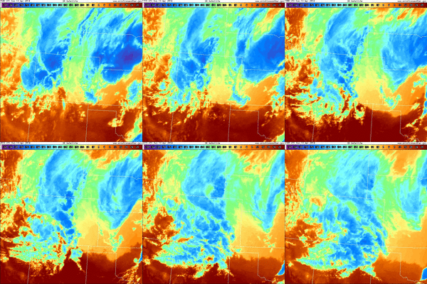
The storm forecast for closing day was indeed interesting! The Steamboat ski area reported 2” mid / 3” top at 5 am as some convection ahead of the cold front brought rain to the valleys and snow to the hill. Then we were affected by 3 pulses of energy, though the first or these was limited in impact as there was only 4” of snow at 1 pm up top.  However, at this time, the second pulse delivered good snow and was quickly followed by a TROWAL (TRough Of Warm air ALoft), which is evident on the IR satellite loop shown on the right (first image at 10:11 am MDT and last image at 5:45 pm MDT on 13 April 2014). This is seen as convective plumes generated over the southern Front Range propagated northwestward over the Continental Divide and into our area. The powdercam at the top of Sunshine Peak showed 6” of snow fell between 1pm and 3pm, with 3.5” falling between 2 pm and 3 pm!
The intense snowfall rates also brought snow to the valleys with over 6” of snow falling in the 5 hours between 11:30 am and 4:30 pm. Additionally, temperatures at Storm Peak Lab near the top of Mt. Werner fell from about 23F around noon to 14F at 4pm, and kept falling through this morning until the temperature reached a mid-winter -1F!
Ski conditions moved from good to great to outstanding, and as advertised in earlier forecasts, the last run of the day was the best, with 10” of snow shown on the powdercam and over a foot measured in the favored areas. The mountain was also relatively sparsely populated due to the events at the base, though I’m sure the mid-winter storm skiing also discouraged those expecting spring conditions!


