Closing day storm delivers the goods
Monday, April 14, 2014
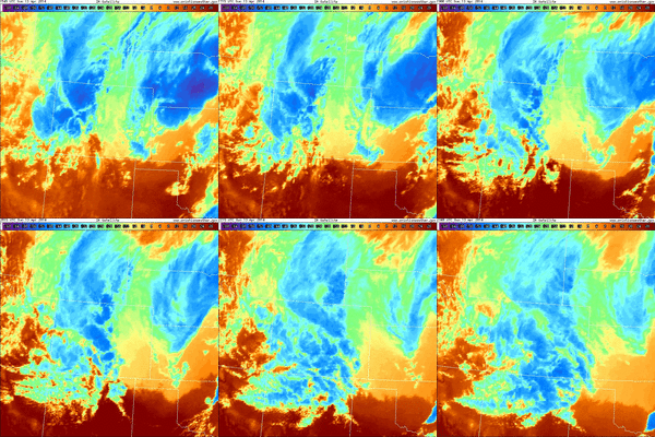
The storm forecast for closing day was indeed interesting! The Steamboat ski area reported 2” mid / 3” top at 5 am as some convection ahead of the cold front brought rain to the valleys and snow to the hill. Then we were affected by 3 pulses of energy, though the first or these was limited in impact as there was only 4” of snow at 1 pm up top.  However, at this time, the second pulse delivered good snow and was quickly followed by a TROWAL (TRough Of Warm air ALoft), which is evident on the IR satellite loop shown on the right (first image at 10:11 am MDT and last image at 5:45 pm MDT on 13 April 2014). This is seen as convective plumes generated over the southern Front Range propagated northwestward over the Continental Divide and into our area. The powdercam at the top of Sunshine Peak showed 6” of snow fell between 1pm and 3pm, with 3.5” falling between 2 pm and 3 pm!
The intense snowfall rates also brought snow to the valleys with over 6” of snow falling in the 5 hours between 11:30 am and 4:30 pm. Additionally, temperatures at Storm Peak Lab near the top of Mt. Werner fell from about 23F around noon to 14F at 4pm, and kept falling through this morning until the temperature reached a mid-winter -1F!
Ski conditions moved from good to great to outstanding, and as advertised in earlier forecasts, the last run of the day was the best, with 10” of snow shown on the powdercam and over a foot measured in the favored areas. The mountain was also relatively sparsely populated due to the events at the base, though I’m sure the mid-winter storm skiing also discouraged those expecting spring conditions!
Add comment
Fill out the form below to add your own comments


