
Gorgeous weather ahead of warm, wet and windy midweek storm
Sunday, February 22, 2026
A gorgeous day is over Steamboat Springs late this Sunday morning with sunny skies and temperatures around 20 degrees at all elevations, rising to near 40 degrees in town and upper twenties at the top of the Steamboat Ski Resort. Even warmer temperatures on Monday will persist through the rest of the week, despite a windy storm on Wednesday that will be accompanied by significant precipitation, with, unfortunately, mostly rain in town.
 After receiving 21” of snow at mid-mountain and an unofficial 28” up top from Tuesday night through Friday, a ridge of high pressure is over the West, sandwiched between a large eddy of low pressure over the eastern Pacific and a broad trough of low pressure over eastern North America, bringing a Nor’easter to the Northeast today.
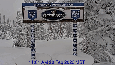
I say unofficial since Steamboat inexplicably reported only 4” up top on the Saturday morning ski report, even though the upper-mountain Powdercam showed an incredible 10” of snow falling between 11 am and 3 pm on Friday, highlighted by a couple of times when 1” of snow fell in only 20 minutes!
While I expected some additional snow on Friday night, the drying atmosphere had other plans, stopping the snowfall early in the evening and bringing a beautiful, crisp winter day to Steamboat Springs on Saturday.
Temperatures will warm under the ridge of high pressure, with the high reaching 40 degrees in town today and the mid-forties on Monday, above our slowly rising average of 37 degrees, with sunny daytime skies. These high temperatures in the 40s will persist through the workweek.
Meanwhile, a wave of energy rounding a ridge of high pressure over the Dateline has split over Alaska, with some energy elongating the eastern Pacific eddy to the southwest, and some continuing southeastward across British Columbia. The eddy extends far enough south to ingest an atmospheric river of moisture from near Hawaii, the so-called Pineapple Express, that will combine with the moisture now spinning around the eddy, which is impacting the Pacific Northwest.
Additional waves of cold air moving across British Columbia will flatten the western ridge of high pressure through midweek, guiding the Pinapple Express over the ridge and toward our area by later Tuesday. Expect increasing clouds and breezes on Tuesday, followed by possible late-day precipitation with snow levels around 8,000′.
Snowfall timing on the hill is uncertain due to the elongated trough over the eastern Pacific splitting, but the windy conditions are not. Expect sustained westerly winds up to 35 mph on Wednesday, with gusts up to 60 mph. Snowfall on the hill could occur anytime between Tuesday night and Thursday morning, and is dependent upon whether the atmospheric river is incorporated into the northern part of the split or stays ahead of it, with 5-10” of wet, dense snow likely falling at mid-mountain during the storm.
The ridge of high pressure is forecast to rebound behind the storm, bringing nice weather back to our area either early Thursday or later in the day. This nice, and sadly warm, weather will extend into the weekend, with unsettled weather advertised to reappear late in the weekend or early in the following workweek.
So enjoy the gorgeous start and end to this week, hope for more moisture and colder temperatures than forecast, and I’ll have additional details on the possible return of moisture around the end of the weekend in my next regularly scheduled weather narrative on Thursday afternoon.


